 Necessary Housekeeping
I shouldn’t have to say this, most of you who read this blog are believers. I welcome your comments and thoughts – even your disagreements about anything I or someone else has written or said about Biblical history or Bible prophecy. I want to make something clear though, this blog has not and never will allow unedifying comments about anyone – believer, non-believer, fellow reader, or someone I’ve written about. For some reason the subject of Mount Sinai and the Red Sea crossing has brought out the worst in some of you. If you feel you must insult, gossip or slander me, Joel Richardson, or anyone else, your comments are not welcome here. You can take that nonsense somewhere else.
This blog is just one man’s opinion about Biblical history and Bible prophecy. If you disagree with me that’s great. I’ve told you repeatedly over the years that you should never take my word as the final word about anything Biblical. It is your responsibility as a steward of Yahweh’s word to do your own due diligence. I write about Biblical history and Bible prophecy because I am passionate about these subjects and I believe what the Bible has to say about them. If you get all bent out of shape because I’ve challenged some of your sacred cows, you’d best find someone else’s opinions to read.
For those who don’t allready know from my writings, I believe that mankind (all of us) is hopelessly flawed due to sin and our only hope is Yahweh’s Yeshua – His Salvation (The Hebrew meaning of the word Yeshua/Jesus is “Yahweh’s Salvation”) I believe every one of the Bible’s 66 books has a unique and important place in demonstrating Yahweh’s redemptive plan for mankind. This blog explores the threads of that amazing redemptive plan.
I believe that message is worth sharing and I do so feely. There has not and never will be a shopping cart, a donation button, or products for you to purchase from this site. I don’t want your money and I will not merchandize my opinions about Yahweh’s wonderful word on this site. I invite any of you to be a part of this adventure with me as I explore Yahweh’s wonderful word. I likely will not be correct about everything I believe. If you’d like to express your thoughts or disagreements please do so in a forthright and edifying manner.
Thank you, William
For those of you just joining us this is an ongoing series exploring the location of Mount Sinai and the Red Sea Crossing. I’d encourage you to first read Part I-III including the comments as they provide valuable context and information related to this subject. The following link will take you to those earlier articles.
Part I – Is Mount Sinai in Saudi Arabia?
Part II – The Reed Sea Crossing: Which Gulf of the Red Sea
Part III – Israel’s Crossing of the Reed Sea: The Geographical & Chronological Context
Telling the Whole Story
I don’t know about you but I hate the feeling of being misled. When I’m not given all the information necessary to make an informed decision it leaves me with a bad taste in my mouth. I’m not even talking about maliciously withholding facts. It can be well intentioned, it doesn’ really matter, the bottom line is I like to understand a subject, both its positive and negative aspects, before committing myself to an idea or course of action.
Regarding the Red Sea crossing in the Gulf of Aqaba it often seems as if it is being sold like a really good looking used car. When I first heard about it from one of Ron Wyatts presentations, I thought it made so much sense. Frankly it looked to me like the Ferraris of Red Sea crossing theories. It sure looked good at a distance! It wasn’t until years later when I popped the hood for myself and took a closer look that all sorts of problems become apparent.
If you are one who believes that the geographical and chronological context doesn’t really matter in this discussion, that Yahweh’ simply performed a miracle and Israel’s Exodus from Egypt and their subsequent desert journey to the Gulf of Aqaba does not need to conform to an reasonable laws of nature, that in fact, the entire journey was miracle then please don’t read any further. I don’t say this flippantly or lightly, I’m serious. I have no desire to offend you with real facts and physical realities. I’ve written about many controversial aspects of Biblical history and chronology over the past 10 years and this subject by far has offended more of you than any other subject I’ve explored. I personally believe there are real problems with the Gulf of Aqaba crossing theory that need to be addressed, problems that go far deeper than those I’ve already discussed in the first three parts of this series. In my opinion, unless and until these challenges are addressed in a reasonable and balanced (and edifying manner), the Gulf of Aqaba crossing of the Red Sea should be taken with a Berean’s skepticism.
Theory #1 – Israel’s Journey to the Reed Sea at Nuweiba beach on the Gulf of Aqaba
One of the most challenging aspects of the Gulf of Aqaba crossing is the unrealistic claims proponents of this theory make about Israel’s journey across the Sinai. To start with let’s look at the Nuweiba beach crossing itinerary. Most of you have probably seen a map of the Exodus itinerary and the Nuweiba beach crossing similar to this one:
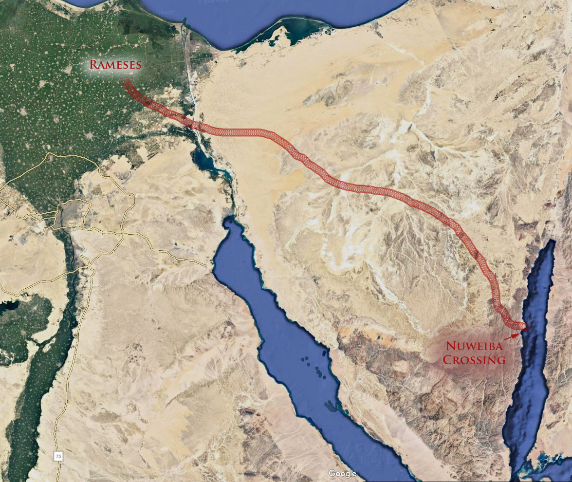
Courtesy Google Earth
Along with a picture similar to this one most accounts go on to tell you that it is between 200-250 miles to Nuweiba beach crossing, which according to the Exodus itinerary could have easily been accomplished in the 25-30 days between the Exodus of Israel from Egypt and Israel’s arrival in the Wilderness of Sin.
Remember Israel left Egypt on the 15th day of the 1st month and arrived in the Wilderness of Sin (after the Reed Sea crossing) by the 15th day of the 2nd month. (This is actually 29 days because the Biblical month is only 29.53 days not 30) In any case here are the Biblical citations for context:
And ye shall observe the feast of unleavened bread; for in this selfsame day have I brought your armies out of the land of Egypt: therefore shall ye observe this day in your generations by an ordinance for ever. (Exodus 12:17)
And they took their journey from Elim, and all the congregation of the children of Israel came unto the wilderness of Sin, which is between Elim and Sinai, on the fifteenth day of the second month after their departing out of the land of Egypt. (Exodus 16:1)
Pretty straight forward right? Israel left Egypt on the 15th day of the 1st month and arrived in the wilderness of Sin (after the sea crossing) on the 15th day of the 2nd month. According to this version of events this means Israel had roughly 29 days to cross the wilderness of Sinai, cross the Gulf of Aqaba (at Nuweiba beach) and arrive in Wilderness of Sin by the 30th day after the Exodus. 250 miles divided by those 29 days gives them a reasonable pace of less than 10 miles per day. That’s pretty doable isn’t it?
Looking under the Hood
Here is what nearly all of these Nuweiba crossing theories are not telling you. At the time of the Exodus the “tongue of the Egyptian Sea (Yam)” as Isaiah 11:15 described it, extended all the way up to Lake Timsah. Further as we learned in Part II of this series, during the reign of Seti and Rameses a wall (shur) was built between this extension of the Heroopolictic Gulf (Suez) and the Mediteranian Sea. In effect these natural and manmade barriers imprisoned Israel in the land of Egypt. These contextual facts explain why Israel needed permission to leave the land of Egypt.
By not telling you this important information, the Gulf of Aqaba proponents present an itinerary substantially less complicated than the Biblical reality. Most in fact (I assume unknowingly) present an Exodus with two Reed Sea crossings, one first through the Heroopolictic (Suez) Gulf of the Reed Sea and another through the Aelantic (Aqaba) Gulf of the Reed Sea. This is a great oversight to say the least. For those who place the Exodus farther north of the Herooplictic Gulf, they also fail to mention that this part of ancient Egypt was fortified with a wall. Again they present their maps as if no such obstacles existed.
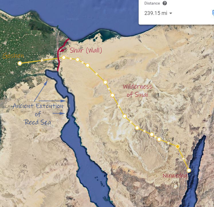
Courtesy Google Earth
(Please note this map is only meant to convey a general idea of the obstacles involved not their exact nature and location)
Obviously Israel didn’t cross the Reed Sea twice, therefore the Exodus (according to Aqaba proponents) must have taken place further north and it must have taken place through Egypt’s wall (shur). This obstacle alone in the most optimistic scenario would have added 3-7 days to Israel’s Exodus from the land of Egypt proper (depending on the size of the gate). This doesn’t even include the 2-3 days march from Rameses/Goshen to this frontier wall.
To help you better understanding the real world implications of the proposed Nuweiba beach Aqaba crossing lets break down Israel’s journey from Goshen/Rameses to Nuweiba beach into stages.
Stage #1
Israel’s journey from Goshen / Rameses to the shur or wall of Egypt.
Here is a summary of the Biblical account.
And the children of Israel journeyed from Rameses to Succoth, about six hundred thousand on foot that were men, beside children. And a mixed multitude went up also with them; and flocks, and herds, even very much cattle. (Exodus 12:37-38)
According to the following Google map it is roughly 40 miles due west from the ancient Egyptian city of Rameses to ancient extension of the Heroopolictic (Suez) Gulf that Isaiah’s described as the “tongue of the Egyptian sea (yam)”. This distance is as the crow flies. It would have been closer to 60 miles if Israel had traveled along the Egyptian highway from Rameses.
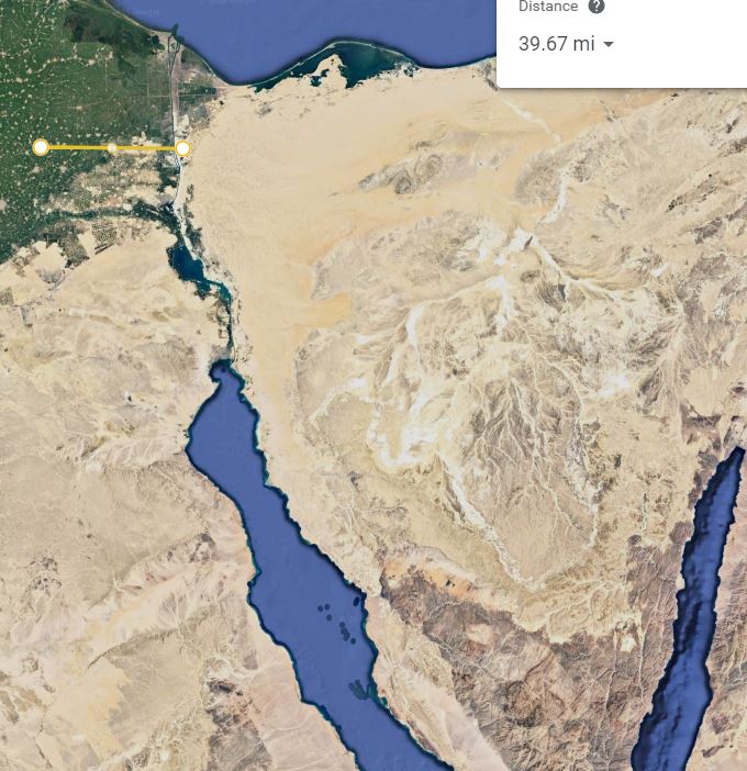
Courtesy Google Earth
Once Israel reach the shur or wall of the Egyptian frontier they would have had to pass through the fortified gates of this barrier. Keep in mind Israel did not pass through the main frontier gate to the north, the so called way of Philistines (Egyptian Way of Horus) because the Biblical account specifically states Yahweh did not lead them that way.
And it came to pass, when Pharaoh had let the people go, that God led them not through the way of the land of the Philistines, although that was near; for God said, Lest peradventure the people repent when they see war, and they return to Egypt: (Exodus 13:17)
This would mean that Israel would have (theoretically) passed through a lesser gate further south, one which let into the wilderness of Sinai. At this point we don’t know how big the gates of Egyptian’s northeastern frontier were. We do know these were defensive positions and the smaller the gates the more defensible.
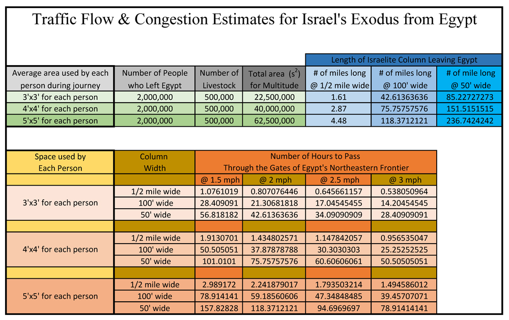
Historically speaking we know ancient Babylon’s main gated entrance was 100’ wide with a long narrow passage that was lined with guard towers and fortifications protecting it. So for the sake of argument lets assume 100’ wide would be the maximum size and possibly 10’ wide a minimum.
Further for this example let’s be generous and make this lesser frontier gate 100’ wide. Based upon my rough chart from Part II of this series, Israel’s multitude when passing through this gate would have made a column equivalent to 75 miles long. Giving the Aqaba theory every advantage, lest say it only took 3-4 days to get all the people and flocks through this frontier gate even though a more realistic scenario would have require well over a week to pass through.
Based upon these rough estimates we can assume it took roughly 6 days for Israel to get from Rameses to a point outside the walls of Egypt proper.
Stage #1 = 6 days – Days left to reach the Wilderness of Sin = 23
Stage #2
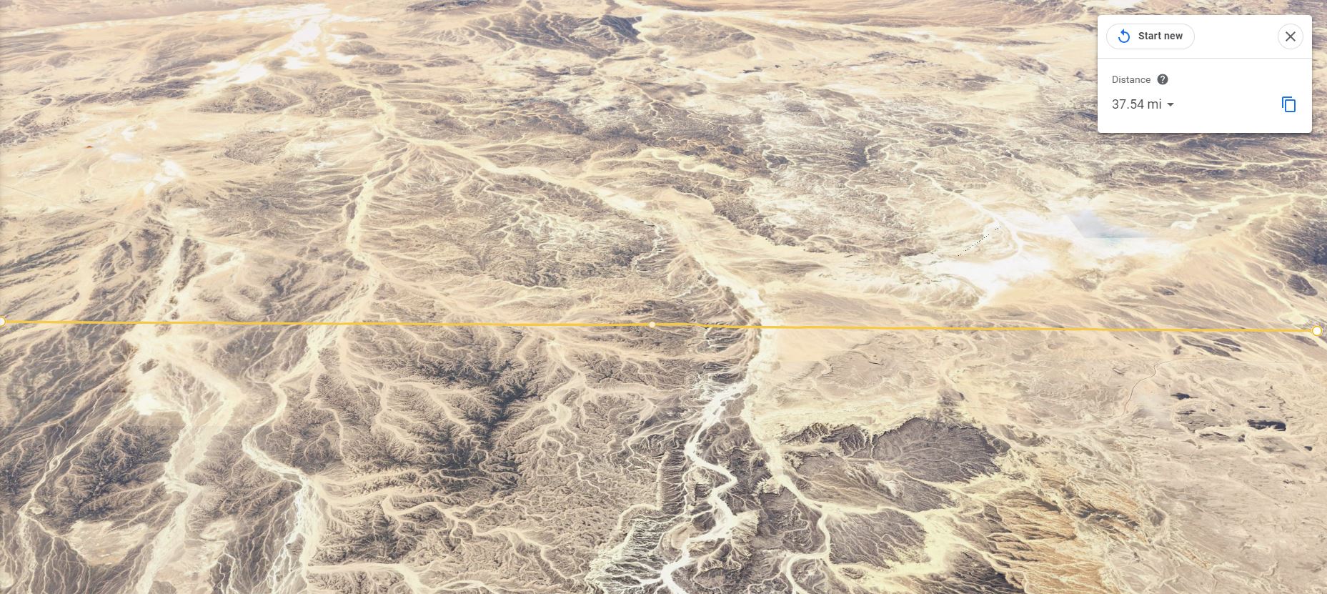
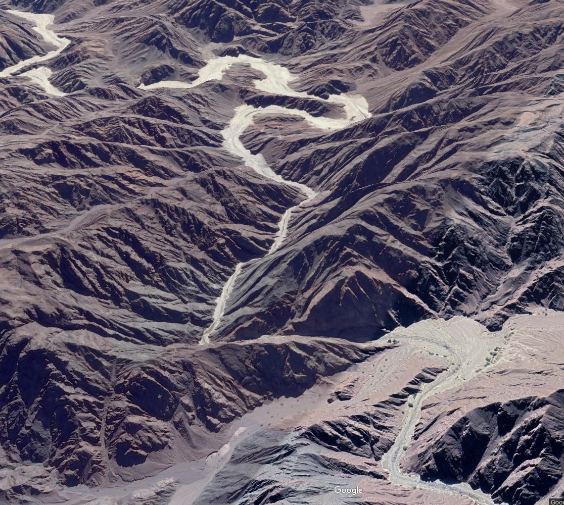
Our next stage in Israel’s journey to the Aqaba crossing at Nuweiba beach by most accounts takes them across the Sinai deserts in a roughly diagonal course from Egypt’s walled frontier to the wadi canyon system that leads to the Nuweib beach crossing of the Gulf of Aqaba. Based upon most maps you see of this itinerary it is represented as roughly a journey of 170 miles. The following Google map gives you an idea of the distance and geography.
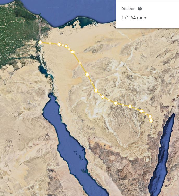
Courtesy Google Earth
What is not explained is this version of Israel’s itinerary is that it is represent as the crow files and does not take into account the natural desert topography of the land.
Let be realistic, there was no ½ mile wide highway for Israel to use when they left Egypt. They might have used parts of existing trade routes between Egypt and tip of the Aelantic Gulf (Aqaba) but for the most part they were traveling cross country or on small caravan routes.
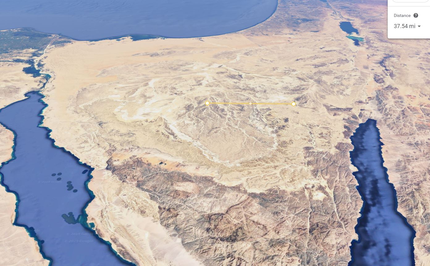
Take a look at three topographical maps showing the natural terrain Israel would have had to cross based upon the itinerary most of the Gulf of Aqaba Crossing proponents suggest. The maps all show the same area but the first starts as a panoramic and then zooms into a close up. Note the yellow measuring bar for context:
Courtesy Google Earth
Courtesy Google Earth
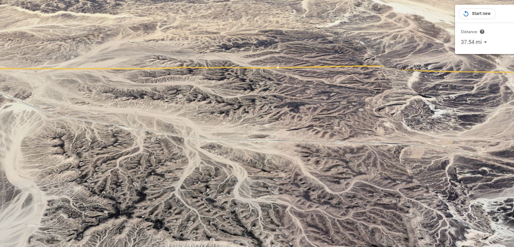
Courtesy Google Earth
Now consider that every mile of Israel’s journey across such terrain would have met ravines, hills, and canyons that would have required them to go over or around. I challenge any of you to take Google earth and zoom in to it highest 3D resolution and see for yourselves what Israel would have had to cross if they took that journey today. Remember all of these obstacles after 3500 years of erosion are less severe than what Israel would have encountered during their journey.
Refer again to my chart above. Each time Israel reached a hill they had to go around it added to the length of their journey. Each time they passed through a wash or ravine 100’ wide (and there are many of them in such a proposed itinerary) it would have taken Israel at least two days for all of the people and animals to pass through. Here is the reality of such a desert journey.
Such a journey would have been 20-50% longer than what most Gulf of Aqaba crossing maps suggest. Forget about 10 miles a day in such terrain. Some days they would have been most fortunate to make 3 or 4 miles with their flocks and children in tow. Again I encourage you to use Google maps yourself and pick a path through the desert wilderness obstacles between Egypt and the wadi’s leaking to Nuweiba beach.
Keeping their Livestock Alive
As an aside without claiming it was a mircle can someone tell me how Israel kept their great multitude of cattle alive on such an extended and fast paced desert journey? Keep in mind that as good shepherds their flocks would have gone first so that any available grazing would have been eaten before it was trampled by the following hordes of people. Unless you believe the Israel carried feed and water for their animals (in addition to their own food and water) the pace of Israel’s journey across the Sinai would not have been dictated by the people but by their animals. Anyone with a little bit of desert ranching background would known that animals in the desert need water (and lots of it) every single day. They might go without food for a few days but even in the spring when Israel left Egypt they would have needed water for their flocks every single day. Not a single account of the Aqaba crossing that I’ve read in the last decade has explained how Israel got their flocks across the deserts of Sinai in the time required without killing them. Not to mention how that many people carried enough water for themselves, their children, and their flocks for such a fast paced and lengthy journey.
Again let’s give the Aqaba theory every advantage and only increase the length of Israel’s journey from the shur (wall) of Egypt to the Wadi’s leading to Nuweiba beach by only 20%. This means then that the actual distance traveled would have been roughly 205 miles. Instead of the 10 miles per day most Aqaba theories suggest lets increase Israel’s speed across the Sinai to 15 miles a day. At this blistering pace it would have taken Israel 14 days to get across the Sinai and to the canyon wadis leading to Nuweiba Beach.
Stage #2 = 14 days – Days left to reach the Wilderness of Sin = 9
Stage #3 – The path through Wadi Watir to the Nuweiba beach crossing.
Now lets look at the most complicated part of their journey to Nuweiba beach, that is Israel’s proposed passage through Wadi Watir which empties onto Nuweiba beach. Here is a current 3D map overview from Google earth.
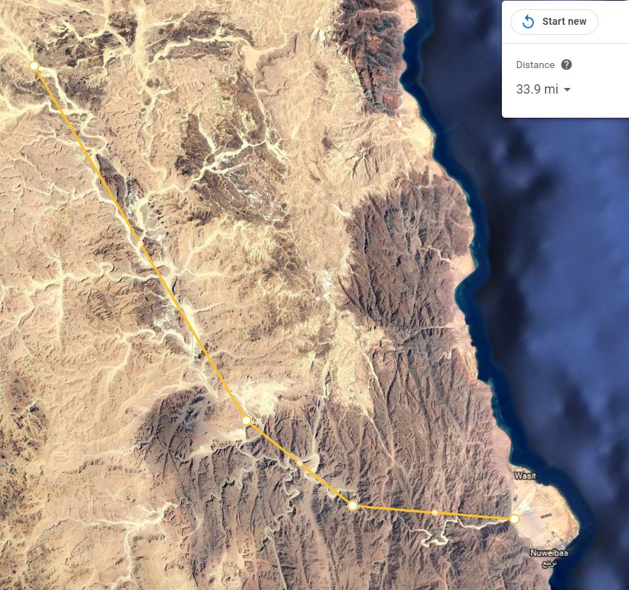
Courtesy Google Earth
Most maps showing Israel’s path through Wadi Watri are similar to the one above. This map shows Wadi Watri and the series of other wadi’s that you can approach it from the North. The total distance appears to be roughly 34 miles according to the map above. What do you think happens when you zoom in on this map and actually calculate the real length of those wadis? The length of such a journey goes from 34 miles to over 51 miles long, over 50% longer! I challenge you to see for yourself.
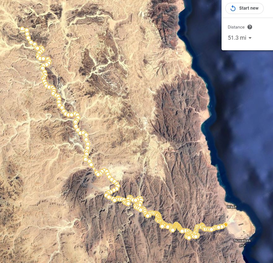
Courtesy Google Earth
But that’s not all the bad news for the Nuweiba crossing theory. Take a look at a close up of the wadi. Even today after 3500 year of erosion and infill, there are numerous locations where the wadi walls are only 100 feet wide. There are even places were the wadi narrows to 50’. Here is one particularly nasty section of the wadi. Notice also the clear evidence of infilling of the wadi after 3500 years of erosion.
Courtesy Google Earth
Can you imagine how narrow that canyon system must have been when Israel must have walked it confines 3500 year ago according to the Aqaba theory?
Think about the real physical implications of this context. At 50’ wide that column of Israel’s passing through just that one point would have been (in the most optimistic scenario) equivalent to 85 miles in length. In more realistic scenario that column would have extended the equivalent of 236 miles. At 15 miles per day, to pass through just that one obstacle it would have taken as little as 6 days and as many as 15 days. For the sake of this example let’s take the average between the best and worst case scenario and assume those restrictions only added 10 days to Israel’s time in the wadi system leading to Nuweiba beach.
Now if we take the 50 miles of actual distance in the wadi’s leading to Nuweiba beach this would require at least 3 more days at 15 miles traveled per day. This gives us a total of 13 days to pass through an obstacle that most Aqaba proponents only show as a 30-35 mile journey.
Let’s say that Israel by some miracle could have carried all the food and water necessary to survive in this canyon system for those nearly two weeks. If the sheep and cattle went first into that canyon system can you tell me what they eat and drink at Nuweiba beach while they waited two weeks for all of Israel’s multitude to reach the beach.
Even if the cattle and sheep waited behind until all the people had made it into the canyon system (contrary to normal modes of such travel) we are still left with the problem of feeding and watering those flocks while they wait and then the further problem of the 4-7 day journey through the canyons with no food or water to eat (assuming they were rushed and their numbers did not exceed several hundred thousand head.)
Even if you cut Israel’s time through the canyon system in half there is no reasonable way to get their herds of cattle and sheep of such a great magnitude though this obstacle alive. This is not just an unrealistic scenario but an impossible one.
Our First Wilderness Trek
This reminds me of an adventure from my youth. Okay, maybe it wasn’t a wilderness trek but it sure felt like it at the time. I was in my early teens and our stepfather took my brothers and sister and I on a week long wagon trip to a canyon in the Chiricahua Mountains of Arizona. I remember it was an old farm wagon painted green with metal hand break next to the wooden wagon and our two big white mules were engines of this iron rimed, wooden spooked method of transportation. The trip took about a week and we made 10 or 15 miles a day depending on the terrain. We were still pretty much city kids at the time and it was truly a great adventure.
Much of the journey was along the side of the asphalt road from our house in Hereford to the Chiricahua Mountains. Part of that journey thought was on dirt roads. Every now and then we had to pass through dry washes that crossed the road. Once those iron wheels of our wagon hit that sand our mules would lung into their harnesses, their muscles bulging, hooves digging into the soft sand as they pulled that wagon through the difficult stretch of road. I can tell you it was no easy task, even with our lightly loaded wagon.
Now picture in your mind the bottom of that 50 plus miles of Wadi canyon system leading to Nuweiba beach. Think about what would have happened to the sand and dirt of that wadi after millions of feet and hooves had churned it to a powdery quick sand like consistency. Consider the hellish, choking clouds of dust that the multitude stirred in the tight confines of the canyon as the Iraelites tried to make it through those hot grasping sands. Anyone who has traveled down a sandy wash that has been churned by cattle or people will tell you it is slow and painful going.
Now suppose that Israel did in fact make it through such a terrible obstacle in the time Aqaba proponents claim. How did Pharaoh pass such and obstacle with his horses and iron wheeled chariots in the short amount of time required without killing the horses? Again this requires us to suspend any reasonable rendering of the facts.
But let’s give the Aqaba theory every advantage once more. Let’s assume it didn’t take the 13 days for Israel and their flocks to make it through Wadi Watir to Nuweiba beach but instead by some miracle it only took a week.
Stage #3 = 7 days – – – Days left to reach the Wilderness of Sin = 2
Stage #4 – Israel Crosses the Reed Sea at Nuweiba
So now after an unrealistic mad dash across the Sinai Peninsula Israel’s multitudes reach the supposed crossing of the Reed Sea at Nuweiba beach on the Gulf of Aqaba. Keep in mind for context sake this trek was the equivalent of the combined populations of Tucson & Phoenix (Arizona’s two largest cities) crossings the deserts between Phoenix and the Pacific ocean and arriving in San Diego in just 28 days.
Now as we explored in last weeks article (here), Israel and all it’s multitudes had to cross the Gulf of Aqaba at a location just as wide as Arizona’s Grand Canyon and half as deep. By the way, for those wondering, Ron Wyatt’s supposed “land bridge” does not exist. Ron supposedly used a “fish finder” in the shallows of the Gulf of Aqaba and then extrapolated his depth measurements all the way across. The following bathymetric chart comes from the Israeli Nathional Bathymetric Survey of the Gulf of Aqaba.
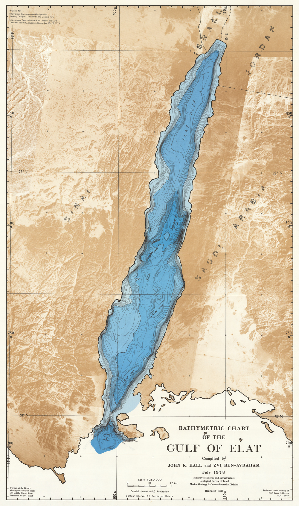
Courtesy Israel National Bathymetric Survey
The chart speaks for itself. In any case, my last article showed that the Aqaba proponents would have Israel crossing this grand canyon of Aqaba in less than two hours. (See Part III of this series for details)
[DISPLAY_ULTIMATE_PLUS]
Again let’s extend every advantage to the Aqaba crossing theory. Let’s assume for our current example that Israel and all their multitudes did indeed make it down and out of the 11 miles of this ocean canyon in less than two hours.
Stage #4 = 1 Day – – – Days left to reach the Wilderness of Sin = 1
Stage #5 – The Journey to the Wilderness of Sin
As you can see we are just about out of time for Israel to reach the Wilderness of Sin. For those die hard Aqaba proponents who still think its possible, here is the Biblical account of this final part of the journey.
And they departed from before Pihahiroth, and passed through the midst of the sea into the wilderness, and went three days’ journey in the wilderness of Etham, and pitched in Marah. And they removed from Marah, and came unto Elim: and in Elim were twelve fountains of water, and threescore and ten palm trees; and they pitched there. 10 And they removed from Elim, and encamped by the Red sea. And they removed from the Red sea, and encamped in the wilderness of Sin. (Numbers 33:8-11)
The above account tells us that after the Reed Sea crossing Israel journeyed 3 days into the wilderness of Etham and pitched at Marah. After Marah they then moved on to Elim, after Elim they retraced their 3 days journey into the wilderness and camped back at the Reed Sea. After returning to the Reed Sea they then moved on to Wilderness of Sin. By the most generous count this itinerary required at least 6 days to reach the Wilderness of Sin.
Itinerary Incongruence
I’ve got to protest some incongruence here. Without blushing nearly all the Aqaba proponents claim that the three encampments described in the Bible between Rameses and the Reed Sea took as many as 30 days to a accomplish. (As we’ve seen above, this is in no way a reasonable representation of the facts described in the Biblical account.) And yet, the same Aqaba theory supporters go on to claim without equivocation that the four encampments after crossing the Reed Sea took only 6 days or less. Now come on, that is a double standard if I ever saw one. How do three encampments cover nearly a month of time yet four encampments after the Reed Sea crossing only require 6 days?
In any cases my protestations notwithstanding, lets again give the Aqaba theory every advantage and assume for this example it only took six days for the Israelites to go “three days into the wilderness”, camp at Marah, then at Elim, return to the Reed Sea, and then move on to the Wilderness of Sin.
Stage #5 = 6 days – Israel arrives in the Wilderness of Sin 5 days late.
Conclusion
Even given every advantage to the Nuweiba crossing theory (to the point of making it a quasi miracle), by no even unreasonable approximation of those events could Israel have arrived in the Wilderness of Sin by the 15th day of the 2nd month.
Theory #2 – Crossing the Gulf of Aqaba at the Straights of Tiran
Some have argued that indeed, the Nuweiba Crossing is not realistic but Israel certainly could have crossed the Gulf of Aqaba in the lower Sinai at the Straights of Tiran. To be sure this itinerary would remove the challenges of Israel and their march through wadi Watir to Nuweiba beach. This theory comes with its own set of problems though. First off, Stage #1, #5, & #6 would be the same. The only difference would be the Straights of Tiran are not as deep as Nuweiba.
In any case, it still took at least 6 days for Israel to get past the shur (wall) of Egyptian frontier and then the 6 days for Israel to reach the Wilderness of Sin after the Reed Sea crossing. This leaves only 17 days for Israel to make their journey from the Egyptian frontier to the Staights of Tiran. The distance traveled as the crow flies along the western and then southern shore of the Sinai Peninsula is roughly 275 miles. Instead of the 20% additional length to make such a journey a reasonable approximation of the real distant traveled lets only allow a 10% additional distance traveled. This would make the journey just over 300 miles in 16 days. Now lets assume they didn’t really have to cross ravines or valleys nor go around any hills or other obstructions. Basically let’s assume they traveled down the coast of Sinai on ½ wide modern freeway. Such a journey would have still required them to travel nearly 20 miles a day for every one of those 16 days with no days to rest and recuperate. As most ranchers and cattlemen know any faster than 15 miles a day and the cattle don’t really have time to adequately graze along the way. This would have been further compounded by the desert environment of the Sinai. Again such a journey steps outside all known reasonable constrains of human and livestock movement.
Pharaoh Gives Chase
And if you thought the above was stretching the bounds of reason, consider that Pharaoh and his army of chariots had to accomplish the same journey in even less time. Only they would have had the additional difficulty of being required to carry all of the necessary feed for their horse and livestock because there would not have been a blade of grass within miles of where Israel passed. (By the way, a similar challenge is posed by the Nuweiba beach crossing.) How this was accomplished has yet to be explained by any Aqaba crossing theories that I’m aware of.
In any case consider what the Bible says about Pharaoh’s pursuit of the Israelites:
And they took their journey from Succoth, and encamped in Etham, in the edge of the wilderness. ..
And YHWH spake unto Moses, saying, Speak unto the children of Israel, that they turn and encamp before Pihahiroth, between Migdol and the sea, over against Baalzephon: before it shall ye encamp by the sea. For Pharaoh will say of the children of Israel, They are entangled in the land, the wilderness hath shut them in. And I will harden Pharaoh’s heart, that he shall follow after them; and I will be honoured upon Pharaoh, and upon all his host; that the Egyptians may know that I am YHWH. And they did so.
And it was told the king of Egypt that the people fled: and the heart of Pharaoh and of his servants was turned against the people, and they said, Why have we done this, that we have let Israel go from serving us? And he made ready his chariot, and took his people with him: And he took six hundred chosen chariots, and all the chariots of Egypt, and captains over every one of them. And YHWH hardened the heart of Pharaoh king of Egypt, and he pursued after the children of Israel: and the children of Israel went out with an high hand. But the Egyptians pursued after them, all the horses and chariots of Pharaoh, and his horsemen, and his army, and overtook them encamping by the sea, beside Pihahiroth, before Baalzephon. (Exodus 13:20 – 14:9)
If you’ve read the above passage very carefully you’ll see that the Aqaba proponents cannot take this passage in its most natural and reasonable chronological sense. Note that Exodus 13 (above) tells us that Israel camped at Etham “in the ege of the wilderness”. At this encampment Yahweh told Moses that they were to turn back and encamp “before Pihahiroth between Migdol and the sea, over against Baalzephon”.
The text indicates that Israel’s turn back towards Pihahiroth would be the catalyst which would cause Pharaoh to think Israel had become entangled in the land. Remember Yahweh is telling this to Moses at Etham before their turn was made.
Yahweh was setting a trap for Pharaoh
Now the most natural reading of this passage indicates that after Israel made the turn towards Pihahiroth that Pharaoh heart was hardened and he gathered his army and gave chase. If as the Aqaba proponents claim, Etham and Phihahiroth are on the Aqaba side of the Sinai Peninsula, this presents them with the difficult challenge of explaining how Pharaoh had learned that Israel made the turn from Etham towards Pihahiroth. Even more challenging (impossible) would be how Pharaoh after learning of Israel’s turn, managed to cross the entire Sinai Peninsula with his army in the short period of time it took Israel to leave Etham and arrive at Pihahiroth.
Winged Chariots
Okay lets forget about the passage from Exodus 13-14 for the moment. Instead let’s assume Etham was not a chronological marker but instead (for whatever reason) Pharaoh had a vision and decide to give chase several days after Israel had passed through the frontier fortifications of northeastern Egypt. If Israel was traveling at 20 miles per day for 16 days then how fast did Pharaoh have to travel to cover the distance from Rameses to Pihahiroth (near the Straights of Tiran) in several days less time? Again such considerations cause the Aqaba theory to break down and we are left with the explanation that both Israel’s and Pharaoh’s journey across the Sinai to Aqaba were of supernatural origins.
Conclusions
As we’ve seen the Straights of Tiran crossing of the Reed Sea also requires us to suspend disbelief and believe a version of events that supersedes any reasonable rendering of the Exodus from Rameses to Pihahiroth.
Theory #3 – The Traditional Reed Sea Crossing
For any student of Yahweh’s words, our interpretive method is key to how approach complex and difficult subjects such as the Reed Sea crossing. Without a methodical approach our interpretations can become wildly inconsistent. One of the best approaches I’ve ever come across in my studies is the so called Golden Rule of Biblical Interpretation By Dr. David L. Cooper. If applied correctly this rule helps holds our assumptions and speculations in check. The Gold Rule states:
“When the plain sense of Scripture makes common sense, seek no other sense; therefore, take every word at its primary, ordinary, usual, literal meaning unless the facts of the immediate context, studied in the light of related passages and axiomatic and fundamental truths, indicate clearly otherwise.” – Dr. David L. Cooper (1886-1965)
So in this final part of our exploration of the Exodus and the Reed Sea crossing let look at the subject in light of the Golden Rule and see if makes common sense in its most plain and reasonable rendering of the Exodus account. In other words lets do your best to take the events described and see if there is a way to take them at face value without embellishment. Let’s start with a summary from Exodus 13:
And it came to pass, when Pharaoh had let the people go, that God led them not through the way of the land of the Philistines, although that was near; for God said, Lest peradventure the people repent when they see war, and they return to Egypt: 18 But God led the people about, through the way of the wilderness of the Red sea: and the children of Israel went up harnessed out of the land of Egypt. (Exodus 13:17-18)
First of all we know from the Biblical account as well as ancient Egyptian writings that the way of the Philistines was the main coastal trade route between Egyptian Nile Delta and the Middle East. This well know trade route was called the way of the Sea (the Philistine or Mediterranean Sea) and was known by the Egyptian’s as the Way of Horus. Mark Miller of www.ancient-origins.net in his article – Newly Discovered Fortress on Way of Horus in Egypt Stood Sentinel Against its Enemies provides a valuable description of this Way of Horus and its fortress.
( see https://www.ancient-origins.net/news-history-archaeology/newly-discovered-fortress-way-horus-egypt-stood-sentinel-020165)
…This i[s]f the fifth excavated fort of 11 fortresses described in the Way of Horus inscriptions on the walls of the Temple of Karnak at Luxor. The others forts have not been found yet. The fortresses and the Horus Military Route protected ancient Egypt’s eastern borders.
Egyptians fortified the route, also called the Way of Horus, with two parallel walls. The 11 fortresses acted as sentinel lookouts and early alert points before any hostile army could reach the fortified city at Tharu and Egypt proper. There may have been a bustling economy with a commercial and customs zone where taxes may have been collected before people reached the delta, Abdel-Maqsoud said.
“The Ways of Horus was a high road secured by a network of fortresses and provided with water reservoirs, as well as supply and custom stations that were established along the route between the Eastern Delta and South Palestine. It was a vital artery through which the military and commercial traffic between Egypt and Asia flowed,” wrote Abdul Ahman al-Rayedi in his book The Inscriptions of the Way of Horus .
The fort at Qantara was 550 by 275 yards (502 by 251 meters) of mud brick that had several towers standing 13 feet. The towers date from the time of Ramses II, who lived from 1304 to 1237 B.C. AncientMilitary.com says New Kingdom Egypt attained its most military power under Pharaohs Seti I and Ramses II.
The following map gives us an rough idea of the location of the Way of Horus:
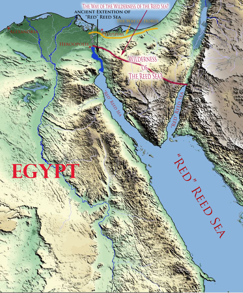
As I’ve demonstrated a reasonable reading of the texts which describe the Exodus and the Reed Sea indicates that both Gulfs what we know today as the Red Sea (gulf of Aqaba & Suez a.k.a Heroopolicitc & Aelantic gulfs) were known as the Reed Sea. Thus when Exodus 13 above describes the “way of the wilderness of the Reed Sea” a reasonable case can be made that it was describing a way or a trade route through that track of land known as the Reed Sea wilderness because in fact this wilderness area was surrounded on three sides by what the Bible describes as the Reed Sea.
The above descriptions provides us with several important geographical points which when combine with what we’ve already explored indicates that Israel after leaving Goshen/Rameses did not go North towards the main fortified highway out of Egypt towards the Promised Land. This information limit’s Israel’s exodus route to someplace south of the Way of Horus and its fortifications but still within the frontier walls of Egypt and the ancient extension of the Heroopolictic gulf (suez), that so called tongue of the Egyptian Yam as Isaiah described it. Let turn now to another couple of passages which add more details.
From Rameses to Succoth
And the children of Israel journeyed from Rameses to Succoth, about six hundred thousand on foot that were men, beside children. And a mixed multitude went up also with them; and flocks, and herds, even very much cattle. And they baked unleavened cakes of the dough which they brought forth out of Egypt, for it was not leavened; because they were thrust out of Egypt, and could not tarry, neither had they prepared for themselves any victual. (Exodus 12:37-39)
And they took their journey from Succoth, and encamped in Etham, in the edge of the wilderness. And YHWH went before them by day in a pillar of a cloud, to lead them the way; and by night in a pillar of fire, to give them light; to go by day and night: He took not away the pillar of the cloud by day, nor the pillar of fire by night, from before the people. (Exodus 13:20-22)
And the children of Israel removed from Rameses, and pitched in Succoth. And they departed from Succoth, and pitched in Etham, which is in the edge of the wilderness. And they removed from Etham, and turned again unto Pihahiroth, which is before Baalzephon: and they pitched before Migdol. And they departed from before Pihahiroth, and passed through the midst of the sea into the wilderness, and went three days’ journey in the wilderness of Etham, and pitched in Marah. (Numbers 33:5-8)
And it came to pass, when Pharaoh had let the people go, that God led them not through the way of the land of the Philistines, although that was near; for God said, Lest peradventure the people repent when they see war, and they return to Egypt: 18 But God led the people about, through the way of the wilderness of the Red sea: and the children of Israel went up harnessed out of the land of Egypt. (Exodus 13:17-18)
From the above passage we learned that Israel left Rameses/Goshen in haste before even their bread had a chance to rise. The text also tells us that Yahweh provided a cloud by day and pillar of fire by night to guide Israel. This then allows for the possibility that Israel could travel at night as well.
Israel’s first camp was Succoth and their second was Etham. Without any additional context the most natural reading of these passages indicates two stops or 1-2 days before Israel reached the edge of the wilderness at Etham. Without further context there is no reasonable plain sense way to claim these two encampments represented the three plus week journey from Rameses to the Gulf of Aqaba as many Aqaba proponents claim.
The Edge of the Wilderness of Etham
Carefully note here that Israel was only at the edge of the wilderness when they camped at the Reed Sea. Only after crossing over the Reed Sea did they enter “into the wilderness” of Etham. This indicates that they were not yet in the wilderness, but were still in Egypt proper. That wilderness of Etham (also called the wilderness of the Wall (shur) was on the other side of the Reed Sea.
And they departed from before Pihahiroth, and passed through the midst of the sea into the wilderness, and went three days’ journey in the wilderness of Etham, (Numbers 33:8)
So Moses brought Israel from the Red sea, and they went out into the wilderness of Shur; and they went three days in the wilderness, and found no water. And when they came to Marah, they could not drink of the waters of Marah, for they were bitter: therefore the name of it was called Marah. (Exodus 15:22-23)
Again if we take this passage in its most natural sense, the edge of the wilderness of Etham (aka shur) was just the distance Israel and it’s multitudes could have traveled by foot (from Rameses) including two encampments or rest stops. This distance fits with what we know today is roughly a 1-2 day journey from Rameses to their frontier wall and the natural barrier of the Heroopolicitic gulf extension of the Reed Sea.
It’s worth noting here that if Israel did indeed travel by night for part of their hasty departure from Rameses/Goshen then the two encampments may have only been rest stops, not all night encampments. Theoretically at least there could have been more than one encampment in a 24hr. period. At the most this gives us roughly 30-40 miles from Rameses/Goshen to the edge of the Wildeness of Etham.
And the children of Israel removed from Rameses, and pitched in Succoth. And they departed from Succoth, and pitched in Etham, which is in the edge of the wilderness. And they removed from Etham, and turned again unto Pihahiroth, which is before Baalzephon: and they pitched before Migdol. And they departed from before Pihahiroth, and passed through the midst of the sea into the wilderness, and went three days’ journey in the wilderness of Etham, and pitched in Marah. (Numbers 33:5-8)
And YHWH spake unto Moses, saying, 2 Speak unto the children of Israel, that they turn and encamp before Pihahiroth, between Migdol and the sea, over against Baalzephon: before it shall ye encamp by the sea. 3 For Pharaoh will say of the children of Israel, They are entangled in the land, the wilderness hath shut them in. (Exodus 14:1-3)
After their encampment at Etham the Biblical narrative indicates that Israel turned back (shuwb) towards Pihahiroth and camped at Migdol “which is before Baalzephon”. In the most plain sense reading of the text this would make Israel travels from Rameses/Goshen to the edge of the wildness of Etham (before the Reed Sea) a journey of roughly 2-3 days. A very possible itinerary that takes into account real geographical and chronological realites.
And they took their journey from Succoth, and encamped in Etham, in the edge of the wilderness. 21 And YHWH went before them by day in a pillar of a cloud, to lead them the way; and by night in a pillar of fire, to give them light; to go by day and night: 22 He took not away the pillar of the cloud by day, nor the pillar of fire by night, from before the people.
And YHWH spake unto Moses, saying, 2 Speak unto the children of Israel, that they turn and encamp before Pihahiroth, between Migdol and the sea, over against Baalzephon: before it shall ye encamp by the sea. 3 For Pharaoh will say of the children of Israel, They are entangled in the land, the wilderness hath shut them in. 4 And I will harden Pharaoh’s heart, that he shall follow after them; and I will be honoured upon Pharaoh, and upon all his host; that the Egyptians may know that I am YHWH.
And they did so. 5 And it was told the king of Egypt that the people fled: and the heart of Pharaoh and of his servants was turned against the people, and they said, Why have we done this, that we have let Israel go from serving us? 6 And he made ready his chariot, and took his people with him: 7 And he took six hundred chosen chariots, and all the chariots of Egypt, and captains over every one of them. 8 And YHWH hardened the heart of Pharaoh king of Egypt, and he pursued after the children of Israel: and the children of Israel went out with an high hand. 9 But the Egyptians pursued after them, all the horses and chariots of Pharaoh, and his horsemen, and his army, and overtook them encamping by the sea, beside Pihahiroth, before Baalzephon. (Exodus 13:20 – 14:9)
Trapped at the Reed Sea
At this point we find Israel trapped between the Reed Sea, the wildeness and the Pharaoh’s approaching chariots and soldiers. It’s worth reiterating here, that in the passage above, if taken in its most natural chronological rendering Yahweh spoke to Moses and told him to turn back towards Pihahiroth so that Pharaoh would think they had become entangled in the land. In other words, instead of leaving Egypt though one of its northeastern border gates, Yahweh purposely had Moses turn south to a point behind the waters of the Reed Sea and draw Pharaoh into a trap. Moses did as Yahweh commanded and Pharoah took the bait. He came after them with a vengeance.
Think about it this way. Yahweh gave Moses the instructions to trap Pharah in Etham, before they turned back and camped at Pihahiroth at the Reed Sea. If this took place as the Aqaba proponents claim, on the other side of Sinai at the gulf of Aqaba, there is no way to take this passage naturally or chronologically. If Etham was at or near the Aqaba Gulf how in world did Pharaoh learn of Israel’s turn back towards Pihahiroth. Even more impossible was how then did Pharaoh manage to assembly his armies and race across the Sinai in a fraction of the time it took Israel to make that journey? I know many explain Israel’s dash across the Sinai Peninsula to Aqaba as Yahweh lending “wings” to their feet. But how does that explain Pharaoh’s chase.
On the other hand if taken plainly, based upon what we know of ancient Egyptian history, geography and the Biblical text, Pharaoh after learning that Israel had turned back towards Pihahiroth, he could have made a mad dash with his chariots from Rameses/Goshen to Reed Sea and his northeastern frontier border in less than a day and there corner Israel at the edge of he wilderness of Etham and the Reed Sea.
Crossing the Reed Sea
So Israel is trapped at the Reed Sea with no hope of escape, they were in their own minds dead men walking. Yet Yahweh had a plan to rescue his people. All night he caused a wind to blow back the waters of the Reed Sea. Then in the morning, in that three hour window before the break of day, Israel’s crossed over and were saved from the wrath of Pharaoh. Those same waters which provided a way of escape for Israel, were the means by which Yahweh judged Pharaoh and his armies. Only the waters of the ancient extension of the Heroopolitic Gulf provide the location where these events can be taken in their most natural and plain sense as described in the Biblical text.
In Summary
Using the Bible’s plainly stated facts and known historical facts from ancient Egypt, a reasonable case can be made for Israel crossing the Reed Sea near Egypt’s northewestern frontier. The Aqaba crossing theory has no such advantage. The Reed Sea crossing in northweastern Egypt is the only explanation which reasonably explains the following facts:
- Israel’s escape from Egypt’s northeastern frontier fortifications in a timely manner.
- The ancient extension of Reed Sea up to and including the Bitter lakes region around lake Timsah
- Israel’s three camps before reaching the Reed Sea – verses Israel’s four camps after
- Israel’s passing through the Reed Sea in less than 3 hours
- Israel’s journey from Rameses/Goshen to the edge of the wilderness of Etham
- Israel’s entering into the wilderness of Etham – after – crossing over the Reed Sea
- Yahweh’s plan to trap Pharoah by telling Moses to turn Israel back towards Pihahiroth
- Pharaoh’s ability to catch Israel after learning they had turned and become “trapped” in the land
In Conclusion
In my opinion, the Aqaba theory of the Reed Sea crossing demands that we view the much of the Exodus narrative in some state of suspended disbelief. Where the theory cannot be explained in the Biblical narrative, miracles are invented to provide a tenuous bridge between Aqaba theory and the physical and geographical realities. I don’t know if the lower Sinai is the true location of the mount Sinai described in the Bible but based upon what I’ve explore in this series, Mount Sinai in Saudi Arabia does not allow the Biblical facts to be taken in their most plain and natural sense.
Epilogue – The Exodus and Reed Sea Crossing: Symbols of the Bible’s Redemptive Message
I know some of you probably think that in this series I’ve been a bit sharp in my criticism of Joel Richardson’s book and his claims about the “true” location of Mount Sinai. Others of you are wondering why I’ve spent so much time on this subject when geography seems but a minor aspect of the Bible’s overall message. As I’ve tried to share with all of you over the years I believe the Bible is a divinely ordered testimony of Yahweh’s redemptive plan for mankind. It is the story of His Yeshua (Salvation).
I believe that unintentionally, Mr. Richardson and many of his peers by claiming that Mount Sinai is located on the other side of the Gulf of Aqaba, have inadvertently voided one of the Bible’s most important symbols of Yahweh’s redemptive plan for mankind. Yahweh willing in a couple of weeks, hopefully in time for Passover, I’ll share with you why the Exodus and the Reed Sea crossing are powerful symbols of Yahweh’s redemptive plan for mankind and why taking what the Bible says about the Exodus chronology in its most natural and plain sense is essential to allowing that symbolism to be understood as it was intended.
[DISPLAY_ULTIMATE_PLUS]
Addititional Research – Toponyms of the Exodus
For those still not convinced by my arguments for the traditional location for the Reed Sea crossing, I would encourage you to read an article (here) by Dr. David A. Falk entitled: What We Know about the Egyptian Places Mentioned in Exodus. Dr. Falk provides reasonable scholarly research which shows how the place names mentioned in the Exodus account can be found in Egypt proper. Dr. Falk even shares an historical account of the word suph (reeds) connected to waters around the ancient Reed Sea of the Biblical account. Here are a few excerpts (in green) from Dr. Falk’s article:
Rameses
Only one city in antiquity had the name Ramesses: Piramesses, which was identified by the Egyptian Egyptologist Labib Habachi (1906-1994) at the archaeological site of Qantir and was conclusively proven to be Piramesses by the wealth of inscriptional material found there.[3]
“Pi/Pr” – Linguistic Conversions between Languages
The Bible calls this site Ramesses rather than Piramesses; this is not unusual, given the minor differences that occurred when Egyptian was reflected in Hebrew. In particular, Hebrew sometimes dropped the pi/pr, “house/estate of” opening that was very common in Egyptian toponymy, e.g., Pi-Amun, Pi-Wadjet, Pi-Thoth, Pi-King-of-Upper-and-Lower-Egypt-Neferirkare, etc.[4] It should be noted that even in Egyptian the pi/pr was also omitted on occasion.[5]
Goshen
Israelites in Goshen
The fact that the delta region was filled with Levantine Asiatics until the mid-19th dynasty fits well with the biblical account of conditions in Egypt up to the exodus since the area around Avaris and Piramesses, what the Bible refers to as Goshen (or “the land of Ramesses,” Gen 47:11), is where the Israelites are said to have dwelt (e.g., Gen 47:6, 27; Exod 8:18, 9:26). But as the term Goshen only appears in the Bible, we do not know if the term has an Egyptian origin or if it is only an Israelite term.[12]
Pithom
Pithom (Etham) and Sukkot
Pithom, also called Etham,[13] was located in the Wadi Tumilat[14] to the east of the Nile Delta, and is identified by scholars with Tell el-Retabah. In ancient times, the road between Piramesses and Pithom would have been about 65 km (40 mi) or approximately 2 days of travel by foot. The wadi provided way stations for semi-nomadic tribes from the Levant and, like the delta in general, had a significant Semitic-Asiatic population during the Second Intermediate Period.
PiHahiroth
Pi-Hahiroth
Pi-Hahiroth[26] reflects the Egyptian pr-ḥwt-ḥrt.[27] The toponym follows Egyptian convention beginning with the hieroglyphic pr-ḥwt, “estate of the temple”[28] or “house of the precinct.” It ends with the goddess determinative[29] indicating that the final element, ḥrt, is theophoric. The name should mean “Estate of the Temple of (the goddess) Heret,” but no such goddess is known.
Early Egyptologists suggested that it might mean “House of (the goddess) Hathor,” assuming that the word ḥrt was an unusual or mistaken spelling of Hathor. William F. Albright suggested that it might mean “the mouth of the canals,” perhaps based on the Akkadian word ḫirītu, meaning “ditch or canal” (CAD 6:201), yet this creative solution ultimately does not solve the problem of the theophoric name.[30]
I would argue that ḥrt may be an abbreviated spelling of ḥry(t)-tp, “the one who is on top.”[31] The term ḥry(t)-tp is one of the epithets of the Uraeus serpent goddess, Wadjet,[32] and therefore, the name would mean, “Estate of the Goddess, who is on top (=Wadjet).”
Location
The toponym pr-ḥwt-ḥrt appears in one extra-biblical text, Papyrus Anastasis III (3:3):
The (Sea of) Reeds (pȜ–ṯwfy) comes to papyrus reeds and the (Waters-of)-Horus (pȜ–ḥr) to rushes. Twigs of the orchards and wreaths of the vine-yards [ … ] birds from the Cataract region. It leans upon [ … ] the Sea (pȜ ym) with bg-fish and bȗrἰ-fish, and even their hinterlands provide it. The Great-of-Victories youths are in festive attire every day; sweet moringa-oil is upon their heads having hair freshly braided. They stand beside their doors. Their hands bowed down with foliage and greenery of Pi-Hahirot (pr-ḥwt-ḥrt) and flax of the Waters-of-Horus. The day that one enters (Pi)ramesses (wsr-mȜˁ-rˁ stp-n-rˁ) l.p.h., Montu-of-the-Two-Lands. (P. Anastasis III 2:11-3:4)
I encourage you to read the entire article here: Egyptian Place Names of the Exodus
Part I – Is Mount Sinai in Saudi Arabia
Part II – The Reed Sea Crossing: Which Gulf of the Red Sea?
Part III – Israel’s Crossing of the Reed Sea: The Geographical & Chronological Context
Part IV – Israel’s Crossing of the Reed Sea: Applying the Golden Rule of Bible Interpretation
Part V – The Exodus & Reed Sea Crossing: Symbols of the Bible’s redemptive Message

I wish to enlighten Struse on a few issues I found in his noble attempt to identify the route of the Exodus. He errs in assuming the “Tongue” of the Egyptian Sea (Isaiah 11:15) is speaking of the Gulf of Suez, which he believes extended to Lake et-Timsah at the east end of wadi et-Tumilat. The yam or “sea” of Isaiah 11:15 is speaking of is the Nile River! In Hebrew yam can apply to (1) a sea, (2) a lake, (3) a river. Today Arabs call the river of Egypt BAHR NIL, SEA NIL (SEA NILE). Why is the Nile called a sea? In antiquity, the Nile flooded annually the Delta of Egypt. At this stage, the Nile took on the appearance of a huge shallow Sea. The villages of the delta were built on raised ground, to resist the floodwaters, so they looked like islands in a great shallow sea (according to Greek geographers who visited Egypt at the time of the flood). Even today the Arabs call these ancient delta cities Jezerah, meaning “islands.” So when God smites the tongue of the Egyptian sea he is smiting the DELTA, which resembles a tongue! That is to say at flood stage the Tongue-shaped Delta has become a “tongue-shaped sea”! After the flood has subsided, the Delta reverts back to its seven channels of the Nile river, and men can pass dry shod over land once covered by flood waters of the Nile. Another misunderstanding is the claim that the Gulf of Suez in antiquity extended to Lake et-Timsah, and included today’s Bitter Lakes. Archaeologists excavated an ancient Egyptian miner’s camp near the east shore of the Gulf of Suez. Taking measurements of its elevation, they then compared it to elevations above and north of the Port of Suez, and realized in antiquity the Gulf of Suez never extended to the Bitter Lakes nor Lake Timsah. It is true that in the 19th century some scholars speculated about the Gulf of Suez extending to Lake Timsah, and located the Red Sea crossing there (as for example Archibald Henry Sayce, 1884). As regards SHUR, in Hebrew it means “wall,” however, we must realize that Egyptian is NOT Hebrew, so SHUR may be a Hebraized Egyptian word, and possibly not mean “wall” in Egyptian. Excavations reveal Egyptian forts to the east of Egypt, at today’s Port of Suez, the site being called Koulzom or Greek Clysma. A Rameside Era fort was found under the Greek period city. The next Egyptian fort is in Wadi et_Tumilat at Tell el Maskhuttah, and Retabeh. Then forts existed near Lake Ballah and Lake Menzalleh, east of the Delta. I have proposed that Shur is possibly preserved at today’s es Suwayr, a well on a track on the north side of wadi et Tumilat. This track ends at Hebron in the Hill Country of Judah, and appears on Bible maps as “the Way to Shur.” I note that the wildernesss of Etham is interchangeable with the wilderness of Shur in the Bible, and es Suwayr is on the northside of Wadi et-Tumilat (for me the wilderness of Etham).
Struse has a map showing SHUR to be a wall, in marker-pen-ink, extending from the Gulf of Suez to the Mediterranean Sea. He also has a photo of an Egyptian gateway and opines about Israel marching through this gate to flee Egypt and wonders how long it would take for Israel (two million Israelites) to get through this gate in the SHUR wall. There is NO such wall extending from Suez to the Mediterranean Sea, it is open wilderness. The three main tracks into Egypt are near the head of the Gulf of Suez, controlled by the Ramesside fort at Greek Clysma (near today’s Port of Suez), the Egyptian forts in Wadi et-Tumilat control the track into Egypt (the way to Shur?), and a track south of Lake Ballah at Ras el Ballah and the northside of Lake Ballah, the so-called WAY OF HORUS, from el Qantir (Rameses and Goshen) to Gaza, with Egyptian forts.
I am aged 76 years, and have studied the Exodus for over 40 years and I have read many scholarly proposals for the Exodus route and Mount Sinai’s location.
I will have to confess here that I began all this research back about 1970 as a devout Christian (non-denominational Protestant, but baptised a Methodist in April of 1943, Philadephia Pennsylvania) seeking to refute skeptics who claimed the Bible was not the word of God. Over the years my Bible studies turned me into a non-believer.
Hi Walter,
Thank you for your comments on the Red Sea crossing.
I’ve edited your posts that did not pertain to the subject at hand and I’ve removed all your external links. I don’t mind you posting about the Red Sea and the historical/Biblical context, but I won’t allow comments that try to undermine the crediblity of the Bible.
I’m truly sorry you’ve lost your faith in the Bible as a testimony of Yahweh’ redemptive plan for mankind.
Warm Regards,
William
I have noted a few typo errors in Struse’s above article, He twice speaks of Israel’s Exodus being via Egypt’s NORTHWESTERN FRONTIER, these typos should be corrected by him to read NORTHEASTERN FRONTIER: “…a case can be made for Israel crossing the Reed Sea near Egypt’s northwestern frontier…the Reed Sea crossing in northwestern Egypt is the only explanation which reasonably explains the following facts…” As I pointed out in my earlier comments (see above) Struse errs in understanding that the Gulf of Suez in antiquity extended to include the Bitter Lakes and Lake Et-Timsah, and he errs in thinking a great brick wall existed from the Gulf to the Mediterranean Sea. I believe Struse has misunderstood earlier scholars’ statements about an eastern “frontier wall.” They mean by this that there was a military controlled frontier via a series of fortresses, there simply is no continuous connecting brick wall linking the fortresses with each other, it is open wilderness waste, no physical barrier exists between the forts except that of the desert itself. As regards Struse’s observations on forage and water for herds of cattle, sheep and goats, he is correct, there is simply not enough forage and water to sustain Israel’s herds in the Sinai. His observation that it is the animals that would limit Israel’s daily miles covered is correct (a healthy man can go about 20 miles a day by himself). The Israeli biblical scholar Menashe Har-El has noted, having been a professional shepherd at one time, that sheep cannot be driven more than 8 or 12 miles a day or they will collapse of exhaustion. This would limit Israel to a daily march of not more than 8 or 12 miles a day between encampments. Struse is again correct in favoring a Reed Sea crossing somewhere near the NORTHEASTERN frontier of Egypt. In fact such a map exists, and can be seen by clicking on the link Struse so thoughtfully has provided his readership entitled Egyptian Place Names in the Exodus by Dr. Falk.
Good morning Walter,
Thank you for pointing out the my typos. Thought I had corrected them all when Joel had pointed them out. Appreciate your attention to detail. I believe I’ve corrected them all now.
Warm regards,
William
Regarding the Wilderness of Shur (Hebrew: shuwr), I have proposed a well called Bir Abu Suwer on a track paralleling the north side of Wadi Et-Tumilat (biblical Etham for me) being Shur. There is, however, for me, an alternate location for Shur, for me, and that is the desert wilderness east of Egypt which appears on Italian map of 1929 labeled Sahara esh Sharqieh, which translates as the “Desert of Sharqieh.” Is Sahara esh Sharqieh the long sought after Wilderness of Shur? It is quite large and could take a three days journey to cross. In Arabic Sharqieh means “East.” A map of 1869 by the French shows a Province de Charquieh as being the eastern delta. The delta would not be considered a desert wilderness but the Sahara esh Sharqieh would.
I have proposed El Qantara to be the Red Sea crossing, but there is again, for me, an alternate location, a marshy area just north of Lake Timsah. It appears on pre-Suez Canal maps for the most part, primarily made by French cartographers in 1826 and 1884. The Bible is very detailed in describing the Red Sea crossing: encamp in front of pi-ha-hiroth, between Migdol and the sea (yam/lake), encamp by the sea (yam/lake), Pi-ha-hiroth by the sea, in front of Baal-Zephon. The Sea divides into a wall of water on the right and left hand, as Israel walks on dry land (Exodus 13:20, 14:1-9). Pi-ha-hiroth according to Strong’s Hebrew Dictionary is pronounced as pee-hah-khee’roth (Strong number #6367) in Coptic (Egyptian) it means “place where the sedge grows.” Perhaps this is a marshy area called El Karach (1826 map) or El Kraieh (1885 map)? It lies just north of Lake Et-Timsah and Wadi Et-Tumilat (Etham?). Baal-Zephon would be Ras el Ballah north of El Karach/Kraieh, Migdol is Bir Makdal (1826) also rendered Bir Magdal (1906 Map, London). The Sea (yam, meaning “lake”) as a wall on one’s right and left hand would be the land passage between Karach/Kraieh on the right hand (heading east) and Ras Ballah and Lake Ballah on the left hand. El Karach/Kraieh lies due west of Bir el Makdal/Magdal. A track passes down this land bridge, going due east from Egypt and Wadi Et-Tumilat. The French map of 1826 calls the track from Wadi Et-Tumilat to Bir Makdal, the “route from Bir Makdal to Belbeis” (a city in the eastern Delta). The other track going north from Wadi Et-Tumilat, towards Ras el Ballah and the Ballah Lake, bypasses the marsh of El Karach/Kraieh on its western side. Under this scenario, Migdol is Bir Makdal/Magdal, Pi-ha-kheeroth is the marsh of El Karach/Kraieh, Baal Zephon is Ras el Ballah and Lake Ballah. Only highly detailed French maps of 1826 and 1885 show all these sites, they don’t appear on other maps. Regards, Walter R. Mattfeld
Further research on my part regarding the location of Shur: The Arabs when asked by European explorers in the 1800s AD where is the Bible’s “Way to Shur,” replied it was called by them the DARB EL SHUR, and it began at Hebron and ended in the vicinity of Lake Et-Timsah in Egypt. I regard this to be an important, crucial, anchor point, for locating the Crossing of the Red Sea by Israel. That is to say, if the Arabs are correct that the Darb el Shur is the Bible’s Way to Shur, then Shur (Hebrew: SHUWR) should be south of the Red Sea Crossing. That is to say, the western terminus of the Darb el Shur determines the Red Sea’s location and its crossing. I note that a well called Bir Abu Suwayr is on the Darb el Shur, just northwest of Lake Et-Timsah, and I have accordingly identified it as being the Shur that is “before” (east of) Egypt. This means the Red Sea is probably north of the Darb el Shur. Pre-Suez Canal maps show that the Nile flooded the area north of the western terminus of the Darb el Shur, filling teh interconnecting lakes of Marash, Ballah, and Menzalleh, with freshwater and in that water were carried seedlings from the Nile’s banks consisting of rushes and reeds being deposited in all of these lakes.
The issue becomes WHERE DID CHARIOTS IN ANTIQUITY HABITUALLY CROSS THIS BODY OF INTERCONNECTING LAKES? An ancient caravan track heading for Gaza from the Northeastern Delta, near modern Salieheh, seems to be the Egyptian WAY OF HORUS. This track crosses the Qantara isthmus, a narrow land bridge, separating Lakes Menzalleh from Ballah. However there is a small canal linking these two lakes, could this canal be Pi-Ha-Hiroth? It appears on the Napoleonic Map of Egypt circa 1826 (surveyed in 1796) produced in Paris, France. Other maps, circa 1796-1855, show the Nile at flood stage flooding this land-corridor, submerging it. This means Chariots would have to ford this land=bridge during the flood season of the Nile. Other times, the flood waters would dissapate and the corridor re-emerge as dryland for a crossing over of the marsh-reed lakes extending from Lake Menzalleh in the north, to include lake Ballah and Marsh in the south. So, if one insists on a crossing for chariots, leaving Egypt, the Qantara land-bridge would seem to be the best location in my opinion. Today this area is covered up in earthen embankments that make the Suez Canal. Only maps pre 1860, show the area and its being flooded by Nile inundations. After crossing the Red Sea (Yam Suph) Israel crosses the wilderness of Shur, that is she crosses the western terminus of the Darb el Shur from Hebron in Canaan. Then Israel camps at Marah, meaning “bitter.” I propose Marah is modern Arabic Murrat, also meaning “bitter” in English, today’s BitterLakes. I note thatthe Aramaic written Peshitta Bible renders Marah as Morath, which seems to be preserved in the Arabic Murrat. After Marah, Morath, Murrat, Israel camps at Elim and its 12 fountains and 70 Palm Trees, for me Ayun Musa, and its 12 artesian springs and nearby palm trees. These springs are actually thermal and are from water deep in the earth going back to the Ice Age according to Geologists. After Elim (Ayun Musa) Israel camps again at Yam Suph (the Red SEa), probably at wadi Gharandal, on the shore of the Gulf of Suez, My Yam Suph Number TWO, Yam Suph Number ONE being north of the Darb el Shur. Finally, there is a THIRD YAM SUPH, encountered after leaving Mt. Sinai and Kadesh, the present Gulf of Aqaba. So, for me there are THREE YAM SUPHS!
Yam Suph in Hebrew is usually translated “Red Sea,” some translate as “Reed Sea.” Not so well known is that Hebrew yam can mean not only “Sea” but also “LAKE,” as in the Dead SEA being a LAKE and the SEA of Galilee being another LAKE! So, the shallow, inter-connected reed-filled lakes of Menzalleh, Ballah and Marash, could qualify as Yam Suph to my way of thinking. These lakes on pre 1860 maps varied in the depth of their water levels, depending on the annual Nile floods. Some areas would be bone dry at times, other times, only 2 feet or 6 feet of water. Chariots would not cross 6 feet of water, but they could ford 2 feet of water. A powerful east wind blows away the water, this is called wind set-down and works only on large shallow bodies of water. These lakes qualify. In 1882 a powerful east wind blew away the eastern half of lake Menzalleh for as far as the eye could see, at Port Said, on the Suez Canal as witnessed by a British General Sir Alexander Tulloch, in his 1904 memoirs published in London. He said boats anchored in 6 feet of water were now on the bottom of the lake with natives walking among them. The wind blew all night, like Moses’ wind!