Part II – Exploring the Claim that Mount Sinai is in Saudi Arabia
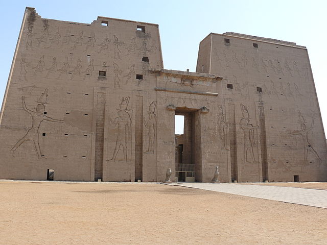
Gate of the Temple of Edfu
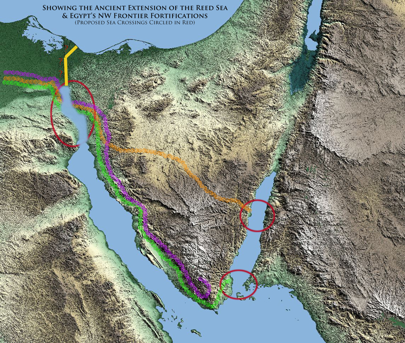
Part I (here) of this series explored the likely geographical context of Egypt at the time of the Exodus. We saw that Israel was contained in the land of Egypt by an ancient extension of the Red Sea which reached up to the area of the present day Lake Timsah. Further, we learned that the Egyptians extended this natural barrier with a wall (shur), motes (canals), and guard towers (migdol) to protect their northeastern frontier, the result of which made for a virtual prison for the children of Israel.
There were only two ways for all the multitude of Israel to have left Egypt: One was through the “Shur” or wall of Egypt’s northeastern frontier, the other through the northern extension of the Heroopolictic (Suez) Gulf of the Red Sea.
(Authors Note: This is an ongoing series exploring the location of Mount Sinai and the Red Sea Crossing. For those just joining the discussion I’d encourage you to read Part I of this series, it provides important context to this subject. Additionally Joel Richardson author of Mount Sinai in Saudi Arabia: The True Location of Revealed whose book we have been exploring in this series has graciously taken time to offer his thoughts and corrections to Part I of my article. You’ll find his thoughts in the comment sections, so be sure to check that out as well.)
The Challenge of an Aqaba Gulf Crossing of the Red Sea
If Israel’s crossing of the “Sea” took place at the Aelantic (Aqaba) Gulf of the Red Sea as many claim, then Israel would have had to leave Egypt through one of its fortified gates. (Unless there were two Red Sea crossings, one first through the Heropoolictic gulf of the Red Sea and then another crossing through the Aelantic (Aqaba) gulf of the Red Sea.)
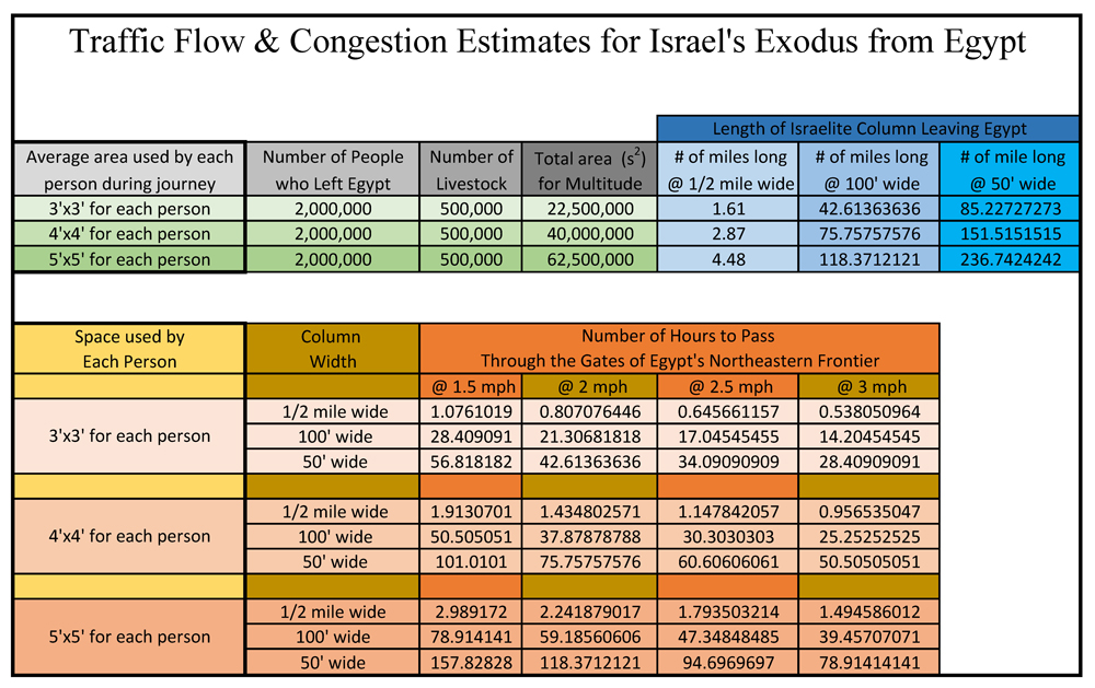
Assuming for the sake of argument, that the generally accepted number of 2 million souls left Egypt and, further assuming, that this multitude took with them half a million head of livestock, the following are some rough numbers on how long it took Israel to exit the northeastern frontier fortifications of Egypt on their way to the gulf of Aqaba:
Keep in mind, as you pursue this chart that the average walking speed of an adult is 2.5 – 3 mph and the average walking speed of cattle is 2 – 2.5 mph. Also, if Israel passed through one of Egypt’s gates, one must take into account traffic flow and congestion. Much like fluid dynamics, the average speed (flow rate) would be reduced significantly at any point where flow is restricted. Keep this in mind for later, because as we will see in the next part of this series it will be another key factor in determining the likelihood of the Nubia beach crossing of the Gulf of Aqaba.
Which Gulf of the Red Sea
The chart above gives us an idea of some of the logistical challenges facing any theory of the Red Sea crossing (including a gulf of Suez crossing). Let’s now look at some details related to the Biblical narrative that might help us determine which gulf of the Red Sea this event likely took place on.
Remember in Part I of this article, we learned that the Greco-Romans world of the apostle Paul’s day considered both the Heroopolicitic and the Aelantic gulfs as part of the Red Sea. Further, the translators of the Septuagint used the Greek designation Eyrthraean (Red) Sea to describe the location where Israel crossed the Sea after their exodus from Egypt. This designation, while not an exact transliteration, was an accurate (though generic) description of the location of the bodies of water the Hebrew Old Testament describes as the Yam Suph or Reed Sea. This is confirmed by New Testament use of Eyrthraean Sea to also describe the Red Sea crossing.
In support of the Gulf of Aqaba crossing, Mr. Richardson in Chapter 4 of his book Mount Sinai in Arabia: The True Location Revealed makes the following observation regarding the Hebrew term Yam:
The first point that we must note is that throughout the biblical narrative, the location of the miraculous crossing is repeatedly called a sea. The Hebrew word, yam is used throughout the Bible to refer to deep bodies of water, such as the Mediterranean Sea, the Red Sea, occasionally the Sea of Galilee, or even the Dead Sea. It is never used of shallow lakes or marshes such as some of the crossing sites suggested north of the Gulf of Suez. (Richardson, Joel. Mount Sinai in Arabia: The True Location Revealed (Kindle Locations 335-339). WinePress Media. Kindle Edition.)
Unfortunately the above statement is not entirely accurate nor does it convey the entire range of the Hebrew Yam as used in the Scripture. First of all, in the Old Testament the Hebrew word Yam is used nearly 80 times to refer to West as in direction. The reason for this is because the Yam Sea (Mediterranean) is to the west of Israel, therefore Yam is often used as a colloquial term to refer to the west, westerly, or western. For example when the Bible describes the locusts being blown out of Egypt, they are being blow by a “Yam” (Westerly) wind.
 Yam is also used in the Bible to refer to the bronze “sea” made by Solomon for the temple, (hardly a deep body of water). And in Jeremiah yam is used to describe the Euphrates River.
Finally, yam is used to describe the very part of Egypt where traditionalists, like myself, believe the Red Sea crossing took place, that is – in the “tongue” of the Egyptian Sea, i.e. the gulf of Heroopolis (Suez), that part of ancient Egypt we know today as the Bitter Lakes
And YHWH shall utterly destroy the tongue of the Egyptian sea [yam]; and with his mighty wind shall he shake his hand over the river, and shall smite it in the seven streams, and make men go over dryshod. (Isaiah 11:15)
Notice this passage describes the Nile delta (seven streams) and the gulf of Heroopolis (Suez) the “tongue of the Egyptian sea”. A reasonable case can be made that this fantastic prophecy was fulfilled when the Heroopolictic gulf receded by nearly 50 miles from its extension at Lake Timsah in ancient Egypt to its present location at Suez today. For those wondering, the Hebrew word lashown (tongue) is also used to describe a bay or tongue of the Dead Sea.
In summary, Yam is not always used to refer to a deep body of water. In fact, as in Isaiah 11:15 demonstrated, it was used to describe the very location where traditionalists believe the crossing of the Red Sea took place or as the Hebrew Bible describes it the “Reed Sea”. For clarity’s sake it should be noted that proposed crossing in the Heroopolictic (Suez) gulf of the Red Sea is also known as the “Reed Sea Hypotheses”.
[DISPLAY_ULTIMATE_PLUS]
Losing the Reed (Suph) Sea
In Chapter 3 – Losing the Yam Suph, Mr. Richardson gives additional reasons why he believes the Reed Sea Hypotheses, in the words of Professor Bernarad F. Batto, “must finally be laid to rest”.
“Despite its popularity, this Reed Sea hypothesis rests upon flimsy evidence indeed. A review of that evidence, plus new considerations make it clear that the hypothesis [the Reed Sea Hypotheses] must finally be laid to rest.”8 Glen Fritz, whose very thorough work The Lost Sea of the Exodus,9 rightly refers to the Reed Sea Hypothesis as being built upon nothing more than “linguistic conjectures and not biblical geography”10 These argue that the correct translation is something more akin to the “Sea of the End.”11 As Fritz points out, of the 116 total times that the Bible uses the word Suph or one of its variants, there are only four instances that can be argued to connect the word to reeds or some kind of plant.12 Alternately, the word is used eighty-seven times to mean “end,” “cease,” “perish,” “fulfill,” “consume,” “hinder part,” or something similar.13 In this view, Yam Suph is thus the sea at the southern-most end of the promised land.14 Alternately it is: “that distant scarcely known sea away to the south, of which no men knew the boundary. It was the sea at the end of the land.”15 As we will see, this view synthesizes perfectly with the consistent testimony of Scripture. When we understand the Hebrew phrase Yam Suph to refer to the body of water known today as the Gulf of Aqaba, the same body of water that is consistently used in Scripture to refer to the southeastern border of Israel, then so much of the accumulated haze and confusion simply disappears. [Insertion added by WS for clarity] Richardson, Joel. Mount Sinai in Arabia: The True Location Revealed (Kindle Locations 287-301). WinePress Media. Kindle Edition. )
Moses hidden in the Suph
While indeed the word “suph” is used in the sense of the end or the end of something. It should be noted for context’s sake that the first usage of this word is found in Exodus 2:3 where it describes the Suph or reeds (flags) Moses was hidden in by his mother, the same plants where Pharaoh’s daughter later found him.
Consider the chronological evolution of the word Suph in the Bible. Suph (reeds or flags) was first used to describe water plants, then a body of water, and still later used to describe the end of something.
And when she could not longer hide him, she took for him an ark of bulrushes, and daubed it with slime and with pitch, and put the child therein; and she laid it in the flags [suph] by the river’s brink. (Exodus 2:3)
And the daughter of Pharaoh came down to wash herself at the river; and her maidens walked along by the river’s side; and when she saw the ark among the flags [suph], she sent her maid to fetch it. (Exodus 2:5)
It is also worth noting that Jonah, when recounting his terrifying journey into the belly of the giant fish, described water plants or suph which wrapped around his head. So even long after the Exodus account the word “suph” was still used to refer to water plants of some kind.
The waters compassed me about, even to the soul: the depth closed me round about, the weeds [suph] were wrapped about my head. (Jonah 2:5)
Symbolically, I find it really neat that Moses was delivered from the sentence of death by being placed amongst the suph (reeds) of the Nile. Then eighty years later, Moses and Israel were delivered when Yahweh’s parted the suph (reed) sea.
Notice in the Isaiah 19 below that the prophet confirms his prophecy from chapter 11 (see above). In chapter 19 Isaiah prophecies that the “water shall fail from the sea” and the “and the brooks (canals) of defence (matsowr = Egypt) shall be emptied and dried up: the reeds and flags [suph] shall wither.”
This passage again confirms a reasonable view of the geological history of the gulf of Heroopolis (Suez). The canals of defense which Egypt built on the outside of their shur (wall) on the Northeastern frontier did indeed dry up, the gulf of Suez receded by 50 miles, and what was once a fortified frontier became wilderness that could be crossed on foot without restriction.
And the Egyptians will I give over into the hand of a cruel lord; and a fierce king shall rule over them, saith the Lord, YHWH of hosts. And the waters shall fail from the sea, and the river shall be wasted and dried up. And they shall turn the rivers far away; and the brooks [canals] of defence shall be emptied and dried up: the reeds and flags [suph] shall wither. The paper reeds by the brooks, by the mouth of the brooks, and every thing sown by the brooks, shall wither, be driven away, and be no more. (Isaiah 19:4-7)
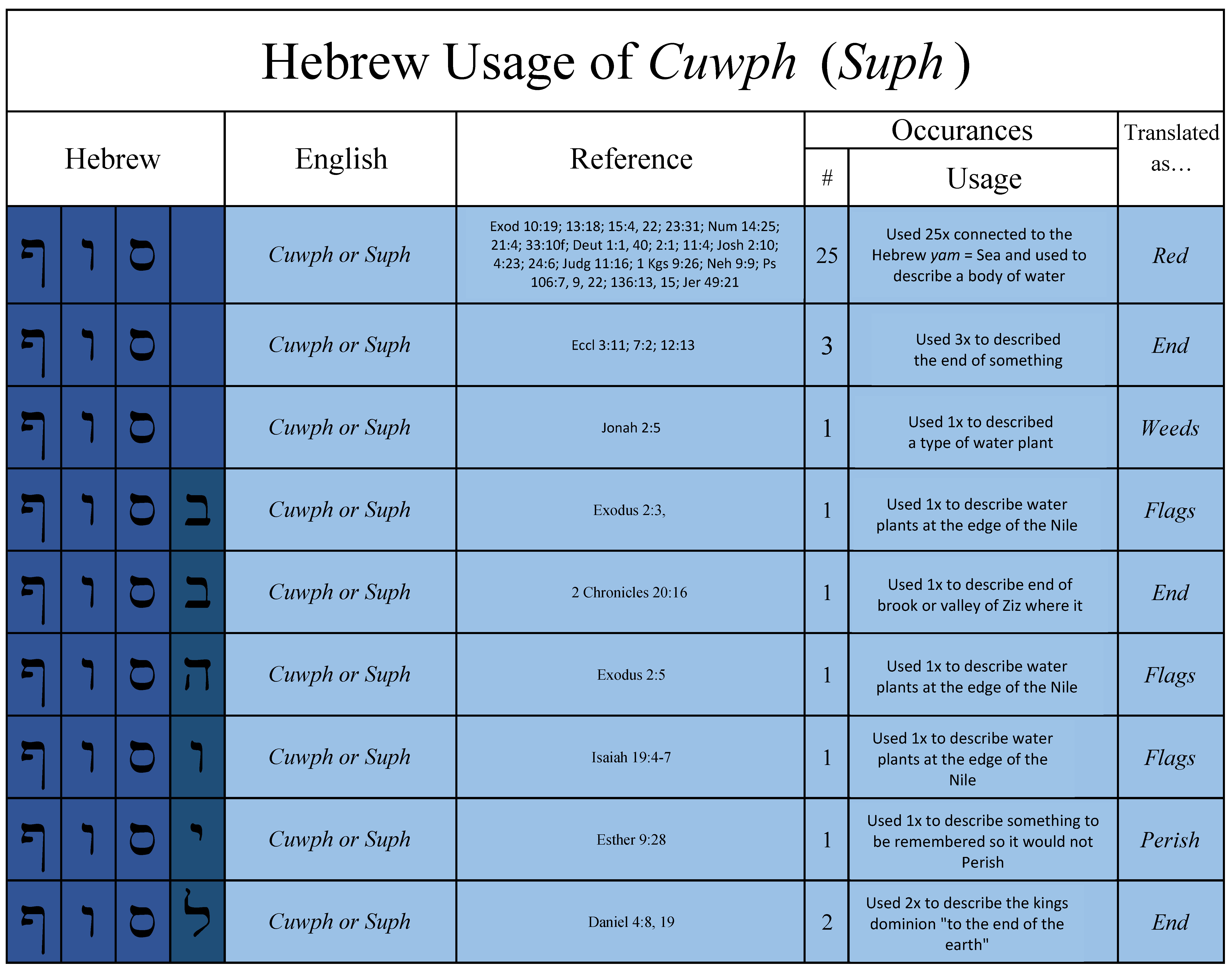
The Hebrew Usage of Cuwph (Suph)
In the following chart, you’ll find Suph or Cuwph as it is used in the OT. In this chart I’ve only provided Hebrew words variants that included the same root spelling as used to describe the Exodus (Reed) Sea crossing. Especially note the chronological usage of the word.
Locusts and the Yam Suph (Reed Sea)
Another consideration when trying to determine the location of the Hebrew Yam Suph (Reed Sea) is the statement of Exodus 10:19 where it describes a strong west (yam) wind which drove all the locusts in the land of Egypt into the Yam Suph (Reed Sea). In his book Mr. Richardson claims this verse proves that the Yam Suph mentioned in this passage is the gulf of Aqaba. His arguments are summed up in four points as follows:
1. The Sea of Reeds (Bitter Lakes region) is far too limited a body of water for this to take place.
2. The locusts were “said to no longer be in the land of Egypt”.
3. The Bible does not say they drowned only the wind drove them that direction
4. The shape of the land of Egypt
The following is an excerpt from Mr. Richardson’s book to give you an idea of his arguments:
The single exception in all of the Bible that traditionalists consistently use in their attempt to prove that Yam Suph may at times refer to the marshy lakes north of the Gulf of the Suez is Exodus 10:19: “So the Lord shifted the wind to a very strong west wind which took up the locusts and drove them into the Red Sea; not one locust was left in all the territory of Egypt.” The common assumption is that this west wind drove the locusts to their deaths into the marshes and lakes north of the Gulf of Suez. There are four problems with this. Richardson, Joel. Mount Sinai in Arabia: The True Location Revealed (Kindle Locations 446-450). WinePress Media. Kindle Edition.
The fourth problem concerns the shape of the land of Egypt. Again, we note that the text says that the locusts covered the entire land of Egypt. Since the traditionalist argument is that the Yam Suph here refers to the “Reed Sea,” specifically the marshy lakes to the north of the Suez, this would mean that the locusts in southern Egypt would have had to have been blown in a northeastern direction, whereas the locusts around the northern Nile Delta would have had to have been blown in a south-westerly direction. Winds do not blow in opposite directions at the same time however. Since the winds were said to be blowing from the direction of the Mediterranean Sea, they would have blown in a south-westerly direction, and thus driven the locusts toward the Gulf of Aqaba. Richardson, Joel. Mount Sinai in Arabia: The True Location Revealed (Kindle Locations 460-465). WinePress Media. Kindle Edition.
And YHWH turned a mighty strong west wind, which took away the locusts, and cast them into the Red sea; there remained not one locust in all the coasts of Egypt. (Exodus 10:19)
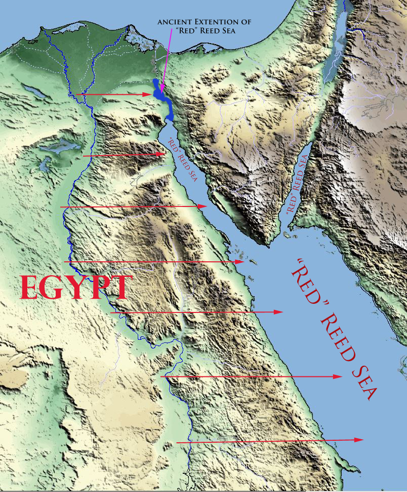
To help you wrap your mind around what is being described here, below is a map of the land of Egypt. Remember that the Scripture states the locusts covered “all the land of Egypt” and all the land of Egypt includes both upper and lower Egypt.
[DISPLAY_ULTIMATE_PLUS]
Part of the confusion surrounding this subject is that many commentators limit the Reed (Red) Sea to either the Heroopolictic (Suez) or Aelantic (Aqaba) gulfs of the Red Sea. This confusion is further compounded by those not acquainted with the fact that in ancient times the Heroopolictic (Suez) gulf of the Red Sea extended all the way up to what we know today as the Bitter Lakes. Just as the Greco-Romans like Pliny understood there were two gulfs of the “Red Sea” the Hebrew writers also understood there were two gulfs in the Sea south of Israel, only at the time of the Exodus they were known in general as the “Reed Sea”. Exodus 10:19 proves this. Here take a look:
And YHWH turned a mighty strong west wind, which took away the locusts, and cast them into the Red sea; there remained not one locust in all the coasts [gebuwl = borders or territory] of Egypt. (Exodus 10:19)
Take a look at the map above again. The map reflects all the gebuwl or land of Egypt. There is only one way to understand Exodus 10:19 in its most reasonable and natural sense. As you can see from the map, if a west wind drove the locusts into the “Reed Sea” then all of what we know today as the “Red Sea” was considered the “Reed Sea” at the time of the Exodus.
There is no way to reasonably claim the locusts in all the land of Egypt were driven by a west wind into the most northern part of the Heroopolicitic gulf (Suez). That as Mr. Richardson rightly states would have required the wind to blow from different directions and thus converging on just one location.
Notice also in the map above, the Aelantic gulf (Aqaba) is half the size of the gulf of Heroopolis (Suez). It would be even more unlikely for a west wind (Mr. Richardson claims a southwest wind) to have driven all the locusts in the land of Egyp into or even towards the gulf of Aqaba.
Again the only way to take this passage literally is to understand that all of the water which we know today as the Red Sea (including its gulfs) was in fact understood at the time of the Exodus as the Reed Sea.
Cast into the Sea
There are a couple of more details related to this aspect of the subject that need to be addressed. While Mr. Richardson is correct (quoting Stuart) that the Bible does not say the locusts were “drowned” in the Reed Sea, I believe it is also incorrect to say, as Douglas Stuart notes, that the text only states that the, “…wind blew them in that direction out of Egypt.”13
In looking at nearly 30 different translations of the verse, I cannot find a single one which does not state the locusts where driven, cast, blown, thrown, carried, etc. “into the Red Sea”. I’m not a Hebrew scholar, but it is hard for me to believe all 30 of these scholars somehow mistranslated this passage and it should have only read, “the locusts were blown towards the Red Sea”. In any case, whether they were blown “into” the Reed Sea or “towards” the Reed Sea, the only way this makes sense is if the body of water in question was the Red Sea proper – including its gulfs of Heroopolictic (Suez) and Aelantic (Aqaba).
Blown Out of the Land of Egypt
Another important topic related to the locusts as well as Israel’s Exodus from Egypt is the question of what is meant by the phrase “out of Egypt”. In respect to the locusts Mr. Richardson explains it this way:
Second, once they [the locusts] were driven out, they were specifically said to no longer be in the land of Egypt. As we will discuss below, the Bible defines the land of Egypt as including the lakes to the north of the Suez. (Richardson, Joel. Mount Sinai in Arabia: The True Location Revealed (Kindle Locations 454-456). WinePress Media. Kindle Edition.) [Insertions added by WS for clarity]
The Border of Egypt
A little bit later in the chapter, Mr. Richardson further explains regarding the borders of Egypt:
The Border of Egypt
Before we conclude our discussion of what the Bible says on this matter, we must also consider another critical Scriptural proof for a crossing at the Gulf of Aqaba. The Bible is quite clear in defining the border of Egypt. It is “the Brook of Egypt, now known as the Wadi el-Arish, the natural boundary between the southwestern Negev and the northeastern Sinai Peninsula regions.”19 Wadi el-Arish is 140 miles east of Port Said, Egypt (the northern end of the Suez Canal) and thirty miles west of the Gaza Strip. When the Lord defined the promised land to Abram, He defined it as extending “from the river of Egypt [in the southwest] as far as the great river, the river Euphrates [in the north]” (Genesis 15:18). In other passages, we find the terms “the river of Egypt” and “the border of Egypt” used interchangeably. (Richardson, Joel. Mount Sinai in Arabia: The True Location Revealed (Kindle Locations 499-506). WinePress Media. Kindle Edition.)
In light of all this, there is another critical proof that the exodus sea crossing had to have taken place on the eastern side of the Sinai Peninsula. The Bible informs us that when the Israelites reached the Red Sea, they were no longer in Egypt. Scripture says that, “when Pharaoh had let the Hebrews go, God did not lead them by the way of the land of the Philistines” (Ex. 13:17), instead the Lord led them, “by the way of the wilderness to the Red Sea” (Ex. 13:18a). Then Moses recorded that “the sons of Israel went up in martial array from the land of Egypt” (v. 18b). So somewhere during their march to the Red Sea, the Israelites had crossed out of the land of Egypt. This is reiterated again in the next chapter where it says that as Pharaoh and his armies drew close to the Israelites by the Red Sea, they “became very frightened” and said to Moses, “Is it because there were no graves in Egypt that you have taken us away to die in the wilderness? Why have you dealt with us in this way, bringing us out of Egypt?” (Ex. 14:10-11). Again, this point is critical. The Israelites had not yet crossed the sea, yet they were already outside of the land of Egypt. As we saw above, the Bible places the border of Egypt some 140 miles east of the Nile Delta. Therefore unless we wish to contradict the scriptural definitions of the land of Egypt, it is impossible to say that the Israelites were outside the land of Egypt, while remaining back near the marshy lakes close to the Nile Delta. (Richardson, Joel. Mount Sinai in Arabia: The True Location Revealed (Kindle Locations 510-520). WinePress Media. Kindle Edition.)
So what exactly was meant when the Bible tells us Israel left the land of Egypt? Mr. Richardson makes the point that because the text says that Israel was “out of the land of Egypt” before they crossed the Red Sea and since he believes the Bible places the border of Egypt 140 miles east of the Nile Delta (at the brook of Egypt) then this means that Israel must have been at the gulf of Aqaba the day before crossing the Yam Suph (Reed Sea). Here are a couple of verses that he believes illustrate his point.
But God led the people about, through the way of the wilderness of the Red sea: and the children of Israel went up harnessed out of the land of Egypt. (Exodus 13:18)
And they said unto Moses, Because there were no graves in Egypt, hast thou taken us away to die in the wilderness? wherefore hast thou dealt thus with us, to carry us forth out of Egypt? (Exodus 14:11)
The challenge to such a hypothesis is that Exodus 12 tells us that all Israel “left Egypt” the 15th day of the 1st month. In other words, the phrase “out of Egypt” simply means they left the part of Egypt they were living in at the time, i.e. Rameses (Exo. 12:37). They clearly did not travel all the way across the Sinai Peninsula in one day. Nor did they even make it out of the Nile river valley. In fact, as the chart at the beginning of this article demonstrates, all Israel wouldn’t have even made it to, let alone through, the gates of Egypt’s Northeastern frontiers on the first day of their journey. The following verses demonstrate that the phrases “out of Egypt” did not refer to Israel geographical location relative to the borders of Egypt, but rather their location relative to their habitation in Egypt.
And ye shall observe the feast of unleavened bread; for in this selfsame day have I brought your armies out of the land of Egypt: therefore shall ye observe this day in your generations by an ordinance for ever. In the first month, on the fourteenth day of the month at even, ye shall eat unleavened bread, until the one and twentieth day of the month at even. (Exodus 12:17-18)
And it came to pass at the end of the four hundred and thirty years, even the selfsame day it came to pass, that all the hosts of YHWH went out from the land of Egypt. (Exodus 12:41)
And it came to pass the selfsame day, that did bring YHWH the children of Israel out of the land of Egypt by their armies. (Exodus 12:51)
In summary, the phrase “out of Egypt” is not a statement of Israel’s location relative to the borders of Egypt, but rather describes Israel’s location relative to where they were kept in bondage in Egypt. These verses do not support a Gulf of Aqaba crossing.
I hope this exploration of the subject has given you another perspective on these challenging topics. I encourage each of you to search the Scriptures to see if these things be so.
Yahweh willing in Part III of this series I hope to explore some of the following subjects:
1. The curious Hebrew word for “wall”
2. Why the text tell us the wind blew all night
3. Josephus’ chronological and geographical statements about the Exodus
4. The Song of Moses
5. What was meant when the text states: The Egyptian’s sunk like stones
6. Who were the Midianites, Shechemites, and Kenites?
7. How does the Bible define the borders of Egypt?
8. The unusual Hebrew usage of Nahar and Nachal
9. The three Exodus Itineraries
Maranatha!
Part I – Is Mount Sinai in Saudi Arabia
Part II – The Reed Sea Crossing: Which Gulf of the Red Sea?
Part III – Israel’s Crossing of the Reed Sea: The Geographical & Chronological Context
Part IV – Israel’s Crossing of the Reed Sea: Applying the Golden Rule of Bible Interpretation
Part V – The Exodus & Reed Sea Crossing: Symbols of the Bible’s redemptive Message
I left a comment, but it disappeared before I could give the below info.
Hi Ray,
Sorry you are having trouble. All posts on my blog are moderated and must be approved before posting. I didn’t see a post from you previous to this one. You are welcome to try again. You might try composing it in MS Word or some other word processor first, that way you’ll not have to write it again should it disappear into the internet.
Warm regards,
William
Why then has chariot wheels of gold been found in the gulf of Aqaba
I wonder why Moses would take his father in law’s flock all the way to the tip of the barren Sinai peninsula to graze? (Ex 3:1 Now Moses kept the flock of Jethro his father in law, the priest of Midian: and he led the flock to the backside of the desert, and came to the mountain of God, even to Horeb.)
Hi Bill,
Good to hear from you. It’s a fasinating subject to be sure. Some claim that the “true” Mount Sinai is in northern Sinai not the south (not convinced that’s the case just think its worth considering).
The “land of Midian” is also an interesting subject from a Biblical perspective. I hope to dig into it a bit in my next article. I appreciate your thoughts.
Warm regards,
William
I like the presentation in the video, The Exodus Revealed. However, it seems like Moses brought the children of Israel into the Wilderness of Shur AFTER they crossed the Red Sea. Shur seems to be located west of Kadesh-Barnea toward Egypt. (Ge 16:7; Ge 20:1; Ge 25:18; Ex 15:22; 1Sa 15:7; 1Sa 27:8). Maybe they crossed the Gulf of Suez or thereabouts, and then went by land into Midian where Mt. Sinai is located in Arabia.
I’ll go with Paul’s testimony in Ga 1:17; Ga 4:25.
I am impressed by Bill Bonnell’s logic! He noted, correctly that the Bible speaks of a track near Beersheba, in the Negev, called the WAY TO SHUR, where Hagar, Abraham;’s wife wanders with her son Ishmael, and other verses stating that SHUR LIES BEFORE EGYPT, implying it is east of Egypt, and NOT EGYPT. Most Bible maps show the WAY TO SHUR as a track heading due west from the Negev and ending at Wadi Et-Tumilat and its lake Et-Timsah. Some scholars have proposed that the Wilderness of Etham is to be associated with Wadi Et-Tumilat. Tumilat appears to be preserve the names of two gods, the Egyptian god called TUM, also rendered Atum or Itum, and the Semitic goddess ILAT OR ELAT (the T ending being a feminine form of the god El or IL, whence ALLAH). In wadi Et-Tumilat was excavated by archaeologists a silver bowl with an inscription dedicating to the Semitic goddess, ILAT, or ELAT. My own research suggests SHUR is preserved at a well called Es-Suwayr just north of Wadi Et-Tumilat, on a track that eventually crosses Wadi Et-Tumilat. Perhaps Arabic Et-Tum preserves Etham? The Bible renders the wilderness of Etham alternately as the wilderness of Shur, and es-Suwayr is on the northside of Wadi Et-Tumilat (Etham?). Herodotus asked Egypt’s priests what constituted Egypt? They replied Egypt was all lands watered by the Nile at flood stage. Lands not watered by the Nile were NOT Egypt. As Shur lies before or east of Egypt and it is encountered after crossing the REED SEA, the Reed Sea cannot be the Gulf of Aqabah nor the Suez Gulf, nor Lake Timsah nor the Bitter Lakes.
A correction is in order in regards to my earlier statement. The Red Sea is actually three sites, (1) Lakes Menzalleh-Ballah, (2) the Gulf of Suez, and (3) the Gulf of Aqaba. How so? As the Way to Shur, from Beersheba, ends near Lake Et-Timsah, the Red Sea crossing has to be north of the way to Shur. I identify Shur (Hebrew Shuwr) with a well called Bir Abu Suweira just WNW of Lake Et-Timsah on pre 1860 maps. The way to Shur actually ends at Bilbeis in the Delta. BUT, after camping at Elim’s 12 springs/fountains, Israel camps again at the Red Sea. Identifying Elim’s 12 springs/fountains with Ayun Musa’s 12 artesian springs, the Red Sea has to be the Gulf of Suez, this also fits the statement that the locusts IN ALL OF EGYPT were dumped into the Red Sea by a west wind, as Egypt extends from the Delta to Syene (present day Aswan) and the Gulf of Suez parallels most of Egypt’s east side. Finally, after camping at Kadesh-Barnea in the Negev, Israel camps at Ezion-Geber, a port on the Red Sea in Solomon’s time, making it Red Sea number Three.
Thank you for your comments, Walter.
Regards,
William
Egyptologist James K. Hoffmeier in his book titled Ancient Israel in Sinai, The Evidence for the Authenticity of the Wilderness Tradition , 2005, locates the Israelite crossing of the Reed Sea as north of the Ballah Lakes, at the northeastern border of Egypt, see his various maps in figures 1 through 10, following page 109. This area in antiquity was that of a shallow lake, filled with reeds and marsh grasses dumped in to it by the reed-lined Nile River. Maps of circa 1807 have this area, called then Bahr Menzalleh, as possessing an average depth of 4 feet, but when the Nile flooded it rose to 7 feet. Native boats drawing only 2 feet of water were able to navigate this estuary. In January of 1882 a British general, Alexander Tulloch, was inspecting the Suez Canal for acts of sabotage. He reported a powerful east wind arising, blowing sand in his eyes. He retired that evening to Port Said. This East wind blew all night like Moses’ wind. In the morning, Tulloch reported that Bahr Menzalleh, west of the canal had been blown away as far as the eye could, see, exposing its muddy bottom. Boats docked at the port of El Said that had been anchored in 6 feet of water were now sitting on the estuaries’ muddy bottom and natives were walking about this bottom. Tulloch wondered if this rare event had occurred in Moses’ day? Following scholars of the 1800’s who thought the Reed Sea crossing was at Lake Timsah or the Bitter Lakes, he did not associate Lake Menzalleh with being the Reed Sea crossing as did Hoffmeier in 2005. Maps made before the Suez Canal was built (pre 1860) reveal that Lake Ballah was an overflow extension of Lake Menzalleh via several inlets. Like Menzalleh, it also possessed reeds and marsh grasses via the Nile River. Egyptian chariots crossed these inlets or shallow fords on a highway called the WAY OF HORUS, from Rameses (today’s Qantir) in the Delta to Gaza, which was an Egyptian stronghold. Carl Drews (a devout Christian, of the Lutheran Faith) recently wrote a book about wind-set-down as the physical force behind the Bible’s east wind that parted the Reed Sea titled Between Migdol and the Sea (2006). He, following Hoffmeier (2005), also locates the Red Sea crossing as being north of Lake Ballah.
I place the Red Sea crossing at today’s El Qantara. WHY? This is where THE WAY OF HORUS crosses the inlets between Menzalleh and Ballah (see Map figure 3 by Bietak, in Hoffmeier’s Ancient Israel in Sinai).
A correction Drews wrote his book in 2014 not 2006.
I’ve looked at evidence from all sides, and can reasonably see a crossing at either gulf, but not in the lakes/marshy area to the north. the whole point of the red sea crossing was to show off God’s power in the biggest miracle of Israel’s history. And drowning Pharaoh’s entire army, (no doubt some were good swimmers) only makes sense in a deep water crossing.