 Part I – Exploring the Claim that Mount Sinai is in Saudi Arabia
There are few stories in the Bible that capture our imagination more than the Exodus. It’s a story of the oppressed and the oppressor, of a tribe of shepherds who once favored, fall into disfavor when the winds of circumstance blow from another direction. It was those divine winds of circumstance that cast the once wealthy descendants of Abraham, Isaac, and Jacob into the crucible of slavery and oppression, and through which Yahweh, the living God of the Bible forged a nation of people with a special purpose in His redemptive plan for mankind.
Who doesn’t remember the Exodus stories of their youth? Of the faith and love of Moses’ mother, in order to save her precious son, cast him adrift in the reeds of the Nile rather than see him sacrificed by the calloused hands of the merciless Egyptians.
Who can’t remember at least some of those ten ghastly plagues Yahweh cast upon Pharaoh and the Egyptians because they wouldn’t let His people go. Which of us doesn’t shiver just a little when we picture the blood painted on the doors of Israel’s houses and the grim angel of death as it carried out the bloody sentence upon all of the firstborn in the land of Egypt who were not protected by the sacrificial blood of the lamb, on that fateful night?
And finally, in some way, I think, we can all related to the climax of the story as we stand with Israel on the shores of the Red Sea, our backs to the approaching enemy and we look in vain for a way out of our terrifying circumstances. Then with no hope in sight, Yahweh opens a way to deliverance. That’s the story of the Exodus!
Skeptical that Mount Sinai is in Arabia
With those wonderful and terrible pictures in mind, this week I want to explore the Exodus and the Red Sea crossing, with a goal in mind of providing as strong a historical and Biblical context to these events as I can. Although I’ve long had an interest in this subject, this article was inspired in part by Joel Richardson’s new book – Mount Sinai In Arabia: The True Location Revealed.
It is only fair to Mr. Richardson here to give you a bit of background to this article. A few months ago Mr. Richardson tweeted something about the location of Mt. Sinai that sparked my interest. I replied and we had a bit of back and forth on the subject. Mind you, I think it would be really cool if Mt. Sinai was in Saudi Arabia, but I’m not convinced this is the best understanding of the evidence. In fact, I am very skeptical of these claims. Our back and forth reflected this. But our conversation didn’t end in animosity, because Mr. Richardson did something that is rather rare today. Instead of blowing my criticisms off, he emailed me and asked if I’d give him some constructive criticism on parts of his forthcoming book related to our discussion.
To be up front, for reason we’ll explore in this series of articles, I still don’t agree with Mr. Richardson on the location of Mt. Sinai, but I definitely have a great deal more respect for him. Hats off to a brother in Christ who showed a bit of humility in his willingness seek out another point of view.
If you are interested in this subject I’d encourage you to read Mr. Richardson’s book. He makes a forceful case for Mt. Sinai’s location in Saudi Arabia. You’ll find an array of arguments (some stronger than others) that need to be explored and considered. No matter which side of this subject you take it’s a fascinating subject worthy of any Berean’s time and effort to better understand.
Vectors of Exploration
So, is Mt. Sinai really in Saudi Arabia? In this series of articles we’ll look at some of Mr. Richardson’s arguments in the light of the historical and Biblical context to see if these things be so.
In his book Mr. Richardson approaches the subject of the location of Mt. Sinai from two main angles of exploration. Those vectors include the location of the Red Sea crossing and geographical context of Arabia in light of the Biblical and historical evidence. Mr. Richardson uses these lines of exploration (to good effect I might add) to make his case for the “true” location of Mr. Sinai. His related conclusions are summed up in the following:
As we will see, the first clear reason to believe that Mount Sinai may now be found in modern day Saudi Arabia is because the Bible very specifically locates the Exodus sea crossing at the Gulf of Aqaba, also commonly known as the Red Sea….
Beyond being east of the Gulf of Aqaba, the Bible gives us a second critical witness regarding the location of Mount Sinai. As we will see, Scripture describes Mount Sinai as being either within the territory of, or beside the land of Midian. Thus, determining where Midian was located is essential. (Richardson, Joel. Mount Sinai in Arabia: The True Location Revealed (Kindle Locations 240-242 &535-537). WinePress Media. Kindle Edition.)
Because of the importance these lines of exploration play in Mr. Richardson’s thesis, I think some geographical and historical context related to the “Red” Sea, Egypt, and Arabia will be essential as we explore Mr. Richardson’s arguments. As part of this evidence we will closely examine how the New Testament authors understood the subject as well as their Greco-Roman contemporaries.
Why the Red Sea?
Did you know that the some of the first historical references to the term “Red” Sea come from the Greek’s and Romans? Now this is not the “Red” Sea you are probably picturing in your mind. You see, to the Greek’s and later to the Roman’s all of the bodies of water surrounding the Arabian Peninsula were part of the Erythraean Sea. Erythraean was the Greekword for Red. As reflected in the map below, they called the gulf on the western side of the Arabian Peninsula the “Arabian Gulf” and the gulf on the eastern side of the Arabian Peninsula the “Persian Gulf”. It’s important to keep in mind here that both gulfs were part of the Erythraean (Red) Sea proper.
No one really knows why the Greeks called these bodies of water the Erythraean (Red) Sea, but historians through the centuries theorized several reasons.
- They called it the Red Sea, because of the seasonal bloom of red algae sometimes observed.
- They called it the Red Sea, because of the red corral found in some of its waters. Æschylus, in the Prometheus Loosed as quoted by Strabo seems to confirm this view in the following quote: “There [is] the sacred wave, and the coralled bed of the Erythræan Sea,…. “ (The Geography of Strabo (Volume I, II & III of 3): Literally Translated, with Notes (Kindle Locations 795-798). Transcript. Kindle Edition.
- They called it the Red Sea, because Arabia was associated with the Edomites. Edom comes from the Hebrew word for “Red”.
For chronological context’s sake, keep in mind that the Greek or Hellenistic period began in the 4th century (roughly 323 BC) about the time of their conquest of Ptolemaic Egypt. Although their empire faded in 31 BC and the Battle of Actium, Greek thought was absorbed by the Roman Empire and has had considerable influence to this day.
The following map is based upon a Greek journal titled: Periplous of the Erythraean Sea (1st century AD). It reflects the Greek view of the Arabian Peninsula and the Erythraean Sea at the time.
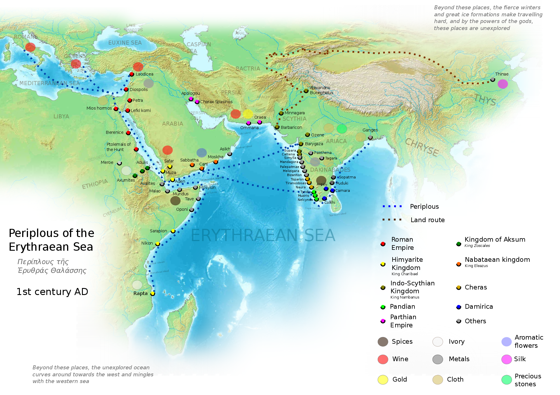
Courtesy of Wikipedia.org
The Greek Influence on the Septuagint
From a Biblical point of view, nowhere was this influence felt more than with the Septuagint version of the Bible. The Septuagint originated roughly 100 years into the Hellenistic period and in the very same location where historians attribute Greece’s rise to power, that is Ptolemaic Egypt. Traditionally, the Septuagint is thought to have originated in the reign of Ptolemy II Philadelphus of Egypt circa 285-246 BC. (For more on this see Paul Lawrence’s: A Brief History of the Septuagint on the ABR website.)
The reason this is important to our exploration of Mt. Sinai and the Red Sea crossing is that it is from the Septuagint that we get one of the earliest, if not the earliest, records of the bodies of water surrounding the Arabian Peninsula being called the Erythraean or Red Sea. Further, the New Testament confirms in two places that this “Erythraean Sea” was the location of Israel’s miraculous deliverance. As Mr. Richardson notes in his book, the Mesoretic text of the Old Testament on the other hand identifies these waters with the Yam Cuwph (Suf). Cuwph in Hebrew means reed or end. (We’ll explore idiosyncrasies of this Hebrew word in more detail later.)
In any case, we can pretty safely attribute the Hellenistic influence of the Septuagint for the Old Testament’s identification of the Red Sea with the bodies of water where the events of Exodus took place. The question is how do we relate the Greek Red Sea with the ancient Hebrew’s Yam Cuwph or Reed Sea?
Greco-Roman Confusion?
In order to answer these questions in the context of Mr. Richardson’s book, we need to look at his understanding of the Greco Roman world view of the Red Sea and Arabia, because this view informs the premises of his book. Here is how Mr. Richardson explains the subject:
The “Red Sea” was essentially a catch-all term used to refer to that distant sea that was very far south. It gets even more complicated though. The Greek geographers of this period actually did not have clarity regarding the piece of land known today as the Sinai Peninsula. The classical Greco-Roman geographers seem to have combined the Gulf of Suez and the Gulf of Aqaba into a single inlet that they called the Gulf of Arabia. In the Greek conception of the world then, there was simply Egypt in the west and the Arabian Peninsula to the east. The piece of land today called the Sinai Peninsula was so obscure that it was almost as if it didn’t even exist. (Richardson, Joel. Mount Sinai in Arabia: The True Location Revealed (Kindle Locations 264-268). WinePress Media. Kindle Edition.)
In the fifth century BC, the Greek historian Herodotus used the term “Arabia” to identify the Arabian Peninsula. In fairness, however, as we have discussed elsewhere, even though Herodotus was not aware that the Sinai Peninsula even existed, he still would have viewed it to be part of Arabia. In the writings of Strabo, another Greek historian-geographer who lived in the first century BC, the Arabian Peninsula continued to be the heartland of Arabia and was called Arabia Felix (meaning “happy,” “blessed,” “fortunate Arabia”). Another smaller region in southern Jordan was called Arabia Deserta. So while it is most certainly possible that in Paul’s day references to Arabia could have been pointing to the Sinai Peninsula, this would have been much more of a secondary reference. If no qualifier was given, the Arabian Peninsula would likely have been understood as the primary region. (Richardson, Joel. Mount Sinai in Arabia: The True Location Revealed (Kindle Locations 1041-1048). WinePress Media. Kindle Edition.)
In the above statements Mr. Richardson seems to be under the impression that the Greco-Roman world had a rather vague or limited understanding of geographical location related to their Red Sea and the Sinai Peninsula. A careful reading of the Greek and Roman historians does not seem to bear this out. The following are a couple of examples:
The Histories by Herodotus (484 -425 BC)
In Arabia, not far from Egypt, there is a long and narrow gulf running inland from the sea called the Erythraean, of which I will here set down the dimensions. Starting from its innermost recess, and using a row-boat, you take forty days to reach the open main, while you may cross the gulf at its widest part in the space of half a day. In this sea there is an ebb and flow of the tide every day. My opinion is that Egypt was formerly very much such a gulf as this— one gulf penetrated from the sea that washes Egypt on the north, and extended itself towards Ethiopia; another entered from the southern ocean, and stretched towards Syria; the two gulfs ran into the land so as almost to meet each other, and left between them only a very narrow tract of country. (Herodotus. The Histories by Herodotus (Enhanced Kindle Edition) (Kindle Locations 1773-1782). Kindle Edition.)
Pliny the Elder, a Roman contemporary of Yeshua and the Apostle Paul had this to say about geographical location of the Red Sea and the geography of the Gulf of Arabia.
CHAP. 12. — THE COASTS OF ARABIA, SITUATE ON THE EGYPTIAN SEA. Beyond the Pelusiac Mouth is Arabia3597[petraea], which extends to the Red Sea, and joins the Arabia known by the surname of Happy3598 [Arabia Felix], so famous for its perfumes and its wealth. This3599 is called Arabia of the Catabanes3600, the Esbonitæ3601, and the Scenitæ3602; it is remarkable for its sterility, except in the parts where it joins up to Syria, and it has nothing remarkable in it except Mount Casius3603. The Arabian nations of the Canchlæi3604 join these on the east, and, on the south the Cedrei3605, both of which peoples are adjoining to the Nabatæi3606.
The two gulfs of the Red Sea, where it borders upon Egypt, are called the Heroöpolitic3607[gulf of Suez] and the Ælanitic3608[gulf of Aqaba]. Between the two towns of Ælana3609 and Gaza3610 upon our sea3611[Mediteranian], there is a distance of 150 miles. Agrippa says that Arsinoë3612, a town on the Red Sea, is, by way of the desert, 125 miles from Pelusium. How different the characteristics impressed by nature upon two places separated by so small a distance! (Pliny the Elder [23-79 AD]. The Natural History of Pliny, Volume 1 (of 6) / by Pliny, the Elder (Kindle Locations 6928-6948). )((Inserts in brakets [] were added by WS for clarity))
Here is a visual of how the Arabian provinces were divided in the Roman times. 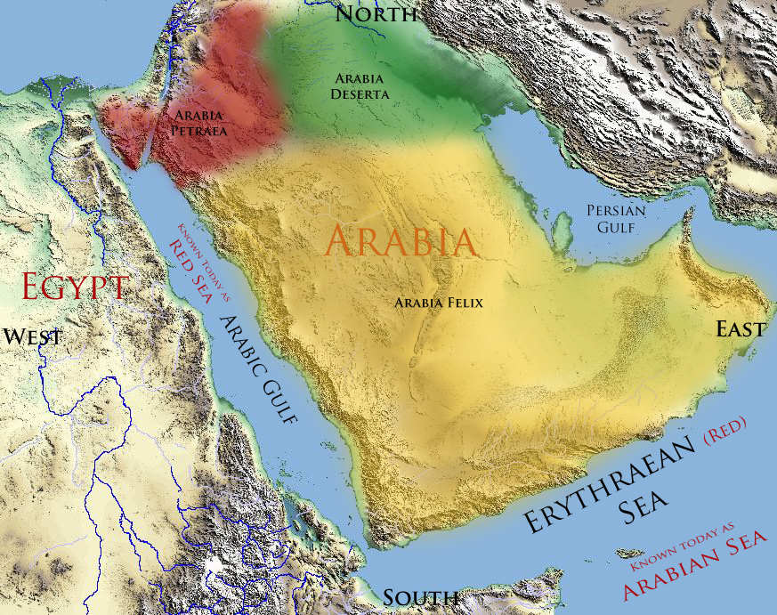
From the above quotes you get the sense that the Greco-Roman geographers did in fact have a rather clear understanding of the Egyptian and Arabian geography.
A couple things to note from these 1st century geographers: First, they understood the Erythraean Sea (Red Sea) to have two gulfs. Pliny described them as the Heroopolitic and the Aelanitic. Further, he understood that the Heroopolitic gulf (today known as the Suez) to be the border between Egypt and Arabia.
What is fascinating about this information is that other Greco-Roman historians as well as archeologists of the modern age identify Heroopolitic gulf and its city Heroopolis with the ancient treasure city of Phitom mentioned in Exodus.
There are a couple neat facts about this information. First, Heroopolis was an important harbor on the Arabic gulf (gulf of Suez) in the Red Sea. This harbor was located all the way up in the area of what today is known as Lake Timsah in the Bitter Lakes of Egypt. This shows that the Red Sea in the days of the Greeks and Romans (and before) terminated much further north than its present location at Suez. (Keep this in mind for later because it becomes quite important information as we look at the route Israel took when they left Egypt.)
Strabo Defines Arabia and the Red Sea
The Greek geographer Strabo who lived from 63 BC – AD 23 confirms the status of Heroopolis as located on “recess” of the Arabian Gulf (gulf of Suez).
…They [who accuse Homer of ignorance] are again mistaken when they say that he was not aware of the isthmus between the sea of Egypt and the Arabian Gulf, and that his description is false,… (Strabo. The Geography of Strabo (Volume I, II & III of 3): Literally Translated, with Notes (Kindle Locations 725-726). Transcript. Kindle Edition.) ((Inserts in brakets [] added by WS for clarity))
In addition to the length, the recess of the Gulf [Arabic Gulf ] is distant from the sea at Pelusium only three or four days’ journey across the isthmus. [Pelusium is a famous city on the Nile Delta near the Mediterranean Sea.] (Strabo. The Geography of Strabo (Volume I, II & III of 3): Literally Translated, with Notes (Kindle Locations 849-850). Transcript. Kindle Edition.)
Egypt too [he says] was formerly covered by sea as far as the marshes near Pelusium, 321 Mount Casius, 322 and the Lake Sirbonis. 323 Even at the present time, when salt is being dug in Egypt, the beds are found under layers of sand and mingled with fossil shells, as if this district had formerly been under water, and as if the whole region about Casium and Gerrha324 had been shallows reaching to the Arabian Gulf. The sea afterwards receding left the land uncovered, and the Lake Sirbonis remained, which having afterwards forced itself a passage, became a marsh. (Strabo. The Geography of Strabo (Volume I, II & III of 3): Literally Translated, with Notes (Kindle Locations 1227-1232). Transcript. Kindle Edition.)
Now the latitude of Heroopolis is about the same as Alexandria, or rather more south. (Strabo. The Geography of Strabo (Volume I, II & III of 3): Literally Translated, with Notes (Kindle Locations 2038-2039). Transcript. Kindle Edition.)
There is said to be a passage thence across, of 1260 stadia, to the city Aila623 (Aelana), situated on the innermost recess of the Arabian Gulf. This recess has two branches, one, in the direction of Arabia and Gaza, is called Ailanites, from the city upon it; the other is in the direction of Egypt, towards Heroopolis, 624 to which from Pelusium is the shortest road (between the two seas). (Strabo. The Geography of Strabo (Volume I, II & III of 3): Literally Translated, with Notes (Kindle Locations 27453-27457). Transcript. Kindle Edition.)
I return to the opinions of Eratosthenes [Greek scholar 276-195BC], which he next delivers respecting Arabia. He is speaking of the northern and desert part, lying between Arabia Felix, Cœle-Syria, and Judæa, to the recess of the Arabian Gulf. From Heroopolis, situated in that recess of the Arabian Gulf which is on the side of the Nile,…(Strabo. The Geography of Strabo (Volume I, II & III of 3): Literally Translated, with Notes (Kindle Locations 27665-27668). Transcript. Kindle Edition.)
Here is a map reflecting Strabo’s view of Egypt and Arabia’s geography. 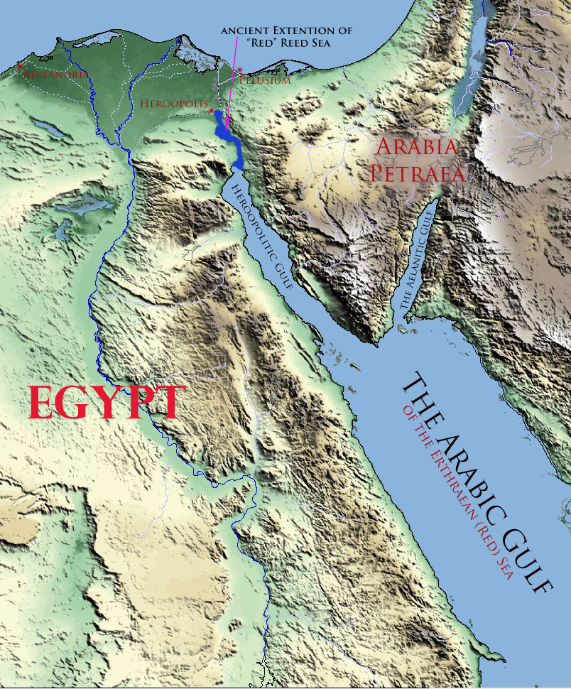 [DISPLAY_ULTIMATE_PLUS]
Frontier Fortifications
Before we really dig into the specific details of Mr. Richardson’s arguments regarding the location of the “Red Sea” and Mt. Sinai, there is one more piece of historical information that we need to explore so that you will better understand the context of Israel’s captivity in Egypt and their Exodus. I believe this context will dramatically change how you view Israel’s captivity and the route they took when leaving the land of Goshen.
And afterward Moses and Aaron went in, and told Pharaoh, Thus saith YHWH God of Israel, Let my people go, that they may hold a feast unto me in the wilderness. And Pharaoh said, Who is YHWH, that I should obey his voice to let Israel go? I know not YHWH, neither will I let Israel go. (Exodus 5:1-2)
Have you ever thought about how Pharaoh kept Israel from leaving Egypt? I mean, why couldn’t they just immigrate in mass or a few families at a time? From the verses above it kind of sounds like the Israelites were prisoners. How could Pharaoh have kept all Israel prisoner?
These circumstances make a lot more sense when you understand that it just wasn’t possible for Israel to leave Egypt without Pharaoh’s permission. In fact it is likely that the Israelites would have needed today’s equivalent of a passport. Let me explain.
As we learned from the history we’ve explored above, Eastern Egypt was protected with the natural barrier of the Red Sea all the way up to city of Heroopolis (the Biblical Phitom) near present day lake Timsah. Between Heroopolis and Pelusium (on the MediterranianSea) there were roughly 40 miles of land not guarded by the natural barrier of the Red Sea. According to archeologists, during the reign of Seti I, due to concerns of invasion from their Asiatic neighbors, a frontier wall (included moats) was constructed across this northeastern section of Egypt’s frontier border. This wall had guard towers and was garrisoned with soldiers. While this frontier fortification did indeed keep unwanted guests from entering Egypt from the east it also kept anyone from leaving Egypt without Pharaoh’s permission.
So when the Bible describes Moses asking permission for Israel to leave Egypt, this permission was in fact necessary because no individual could leave Egypt without passing through the gates of the frontier wall, much less hundreds of thousands Israelites who were valuable slaves.
With the same object he constructed on his north-eastern frontier a wall or fortress “to keep out the Sakti,” who continually harassed the people of the Eastern Delta by their incursions. (Rawlinson, George. The History of Ancient Egypt: The Land & The People of Egypt, Egyptian Mythology & Customs, The Pyramid Builders, The Rise of Thebes, The Reign of the … The Ethiopians & Persian Conquest (Kindle Locations 1010-1011). Madison & Adams Press. Kindle Edition.)
Seti was not dazzled with his military successes. Notwithstanding his triumphs in Syria, he recognized the fact that Egypt had much to fear from her Asiatic neighbours, and could not hope to maintain for long her aggressive attitude in that quarter. Without withdrawing from any of the conquered countries, while still claiming their obedience and enforcing the payment of their tributes, he began to made preparation for the changed circumstances which he anticipated by commencing the construction of a long wall on his north-eastern frontier, as a security against invasion from Asia. This wall began at Pelusium, and was carried across the isthmus in a south-westerly direction by Migdol to Pithom, or Heroopolis, where the long line of lagoons began, which were connected with the upper end of the Red Sea. (Rawlinson, George. The History of Ancient Egypt: The Land & The People of Egypt, Egyptian Mythology & Customs, The Pyramid Builders, The Rise of Thebes, The Reign of the … The Ethiopians & Persian Conquest (Kindle Locations 2275-2285). Madison & Adams Press. Kindle Edition.)
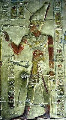
Seti I – Temple Relief Wikipedia.org
We may conclude that Seti was of the true Egyptian race, with perhaps an admixture of more southern blood; while Ramesses, born of a Semitic mother, inherited through her Asiatic characteristics, and, though possessing less energy and strength of character than his father, had a more sensitive temperament, a wider range of taste, and a greater inclination towards peace and tranquillity. His important wars were all concluded within the limit of his twenty-first year, while his entire reign was one of sixty-seven years, during fifty of which he held the sole sovereignty. Though he left the fame of a great warrior behind him, his chief and truest triumphs seem to have been those of peace—the Great Wall for the protection of Egypt towards the east, with its strong fortresses and “store-cities,” the canal which united the Nile with the Red Sea, and the countless buildings, excavations, obelisks, colossal statues, and other great works, with which he adorned Egypt from one end to the other. (Rawlinson, George. The History of Ancient Egypt: The Land & The People of Egypt, Egyptian Mythology & Customs, The Pyramid Builders, The Rise of Thebes, The Reign of the … The Ethiopians & Persian Conquest (Kindle Locations 2425-2432). Madison & Adams Press. Kindle Edition.)
There lay still further to the NORTHEAST, on the western border of the lake called Sirbonis, a place important for the defence of the frontier, called ANBU, that is “THE WALL,” “THE RAMPART WALL,” “THE CIRCUMVALLATION.” It is frequently mentioned by the ancients, though not under its Egyptian appellation, but in the form of a translation. The Hebrews call it SHUR, that is, “WALL,” and the Greeks Gerrhon, Gerrha which means “THE FENCES” or “ENCLOSURES.”….
Whoever travelled EASTWARDS from Egypt, in order to leave the country, WAS OBLIGED to pass the place of “the walls,” before he was ALLOWED to enter the “road of the Philistines,” as it is called in Holy Writ, on his further journey. An Egyptian garrison, under the command of a captain, BLOCKED THE PASSAGE THROUGH THE FORTRESS, which only opened and closed on the suspected traveller AFTER A PREVIOUS COMMUNICATION FROM THE ROYAL AUTHORITIES. Anbu — Shur — Gerrhon formed at the same time the first terminal point of the great military road, which led from the Delta…to the…desert ….(A History of Egypt Under the Pharaohs, by Henry Brugsch-Bey. Vol.I, second edition. John Murray, London. 1881, pps. 238-239.)
“Accounts of this wall indicate a project on the scale of the frontier wall of Britain, built by the Roman emperor Hadrian” — and known to history as “Hadrian’s Wall.” (The Egyptian Pyramids, McFarland and Co., Jefferson, N.C. 1990, p. 198.)
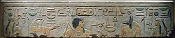
Relief of Amenemhat I – Wikipedi
From recent discoveries we know that though Amenemhet I, the Enemy of the Petrograd papyrus, was regarded as the saviour of Egypt, and was the builder of the great wall in the Eastern Delta made to keep back the Asiatics, yet the war of liberation had already begun under his predecessors of the Xlth Dynasty, the Antefs and Mentuhotps of Thebes, and the retirement of Abram may conceivably have been due to pressure by the Egyptian armies. (Peet, T.E. Egypt and the Old Testament (Kindle Locations 508-513). Liverpool, University Press of Liverpool ltd.. Kindle Edition.)
The Chronological Context of Egypt and the Exodus
To help you understand the context of the quotes above related to Amenemhet I and Seti I, the great wall and the Exodus, the following chart shows the Egyptian Dynasties XVIII and XIX. According to the MT text of the Old Testament, the Exodus took place about 1488 BC. (These charts were adapted by this author based upon the charts of D. Davidson and C. Aldersmith. – WS) [DISPLAY_ULTIMATE_PLUS]
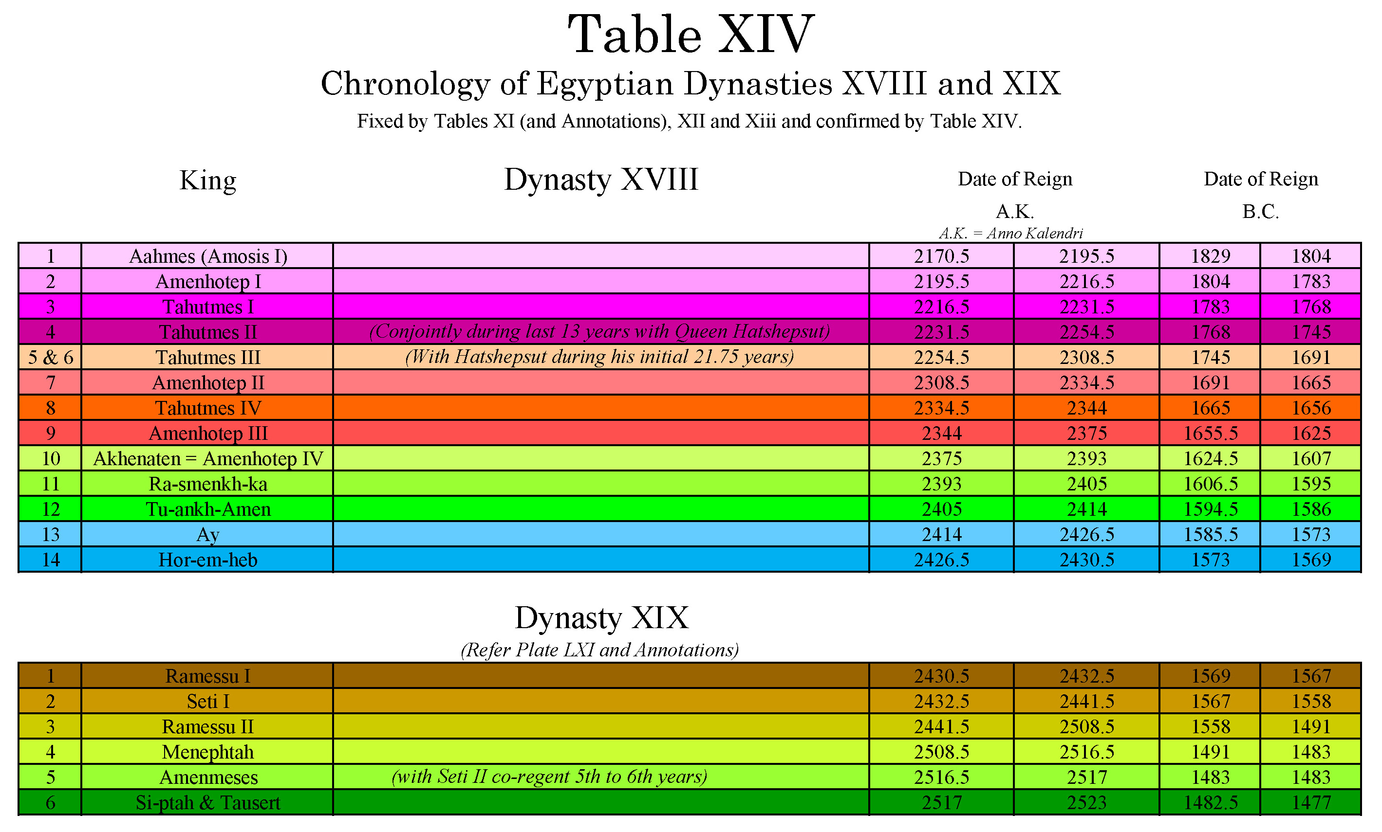
Click on Image to Enlarge
In Summary
From the historical references we’ve explored in this article, it is clear that the Greco-Roman world of the apostle Paul’s day understood that the Erythraean Sea or Red Sea was a body of water which surrounded Arabia. Further they understood that this Red Sea included the Heroopolitic gulf (Suez) and Aelantic gulf (Aqaba) and further that this Heroopolactic gulf (Suez) was the border between Egypt and Arabia.
So in the New Testament when Stephen and the author of Hebrews mentions the “Erythraean” or Red Sea as the location of the Exodus sea crossing, that term in context of their day included both the Heroopolitic (Suez) and Aelantic (Aqaba) gulfs of the Erythraean Sea. The bottom line is that what we know today as the Sinai, both the New Testament and the Greco-Roman historians understood to be part of Arabia. The question remains though, – in which part of Arabia was Mt. Sinai located? We’ll explore this question in more detail in Part II of this series.

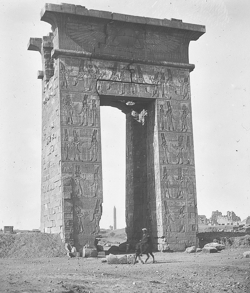
Gate of the Temple of Edfu
A Fun Challenge: How did Israel Leave Egypt?
We’ll continue our exploration of the Exodus, the Red Sea crossing, and the location of Mt. Sinai in Part II of this series, but as you think about the information I’ve shared in this article I challenge you with an exercise in logistics.
There are two main theories today regarding the Gulf of Aqaba as the location of the Red Sea crossing. These theories are best represented by Ron Wyatt and Bob Cornuke. If you take a look at both their maps or drawings of the proposed Red Sea crossing you’ll notice they make no mention of the ancient position of the Heroopolitic gulf of the Erythraean (Red) Sea or the frontier wall in their Exodus route itineraries. (Mr. Richardson does not cover this subject in this book.)
Gate of Ptolemy II Euergetes
In any case, here is a fun challenge for those of you who’ll accept it. Most scholars claim that roughly 2 million Israelites left Egypt plus a great deal of cattle and livestock. Assuming each person or animal took up only 4 sq. ft., and assuming they only took 500K livestock with them when they left, how many miles long would the column of Israelites and livestock have been when they passed through the frontier gate of Egypt into the wilderness of Sinai (if said gate was 100’ wide). And as a secondary exercise, with the above information in mind, how long would it have taken this column of Israelites to leave Egypt proper (the Nile river valley) and enter the wilderness of Sinai based upon Ron Wyatt’s or Bob Cornuke’s itineraries of the Exodus. I’d love to hear your thoughts on this. We’ll consider the implications of this logistical challenge in our next article.
In Part II we we’ll look at several subjects related to Mr. Richardson’s book – including:
- The Hebrew usage of Yam Cuwph
- The Logistics of Israel’s exodus through the Northwestern frontier
- What was meant by “out of Egypt” as it relates to the Red Sea crossing.
- The Red Sea and the Locusts
Yahweh willing until next time – Maranatha!
A Favor to Ask
I have a favor to ask. If you are a regular reader of this blog, you know that you can download all of my books and articles free of charge. I don’t ask for donations or allow advertisements on this blog. This effort is a labor of love for me as a testimony to Yahweh’s wonderful redemptive plan for mankind through Yeshua. I don’t want your money but if you would take a moment to share the articles you read on this blog with your friends and family on Facebook, Twitter, and other social media I would greatly appreciate your help. Together we can share the Biblical evidence for Yahweh’s wonderful redemptive plan for mankind. Thank you for your help in this effort!
* * *
FREE Book Download:
If you would like to learn more about Biblical history and Bible prophecy, you might also appreciate my books in the Prophecies and Patterns series.
At the following link you may download one of the three books shown below. If you like the book and would like to download the other two, all I ask is that you subscribe to my blog. I won’t share your email or spam you with advertisements or other requests. Just every couple of weeks I’ll share with you my love of Biblical history and Bible Prophecy. Should you decide you no longer wish to be a subscriber you can unsubscribe at any time.
Click the following link to download your Free book: Book Download
I hope you’ll join the adventure!
Editors Note: Below are some additional quotes I dug out that might be of interest to some of you. They give a more nuanced view of the how Egypt and Arabian were viewed in the Greco-Roman period as well as some related miscellaneous information.
At last nothing remained to the invaders but their great fortified camp, Uar or Auaris, which they had established at the time of their arrival upon the eastern frontier, and had ever since kept up. In this district, which was strongly fortified by walls and moats, and watered by canals derived from the Pelusiac branch of the Nile, they had concentrated themselves, we are told, to the number of 240,000 men, determined to make there a final stand against the Egyptians. (Rawlinson, George. The History of Ancient Egypt: The Land & The People of Egypt, Egyptian Mythology & Customs, The Pyramid Builders, The Rise of Thebes, The Reign of the … The Ethiopians & Persian Conquest (Kindle Locations 1496-1499). Madison & Adams Press. Kindle Edition.)
Amenemhat [I] ruled over the WHOLE LAND OF EGYPT with power and might, “from the Elephant-city even to the Athu, or lakes in the lowlands;” and that he was wise in thought and deed we learn from many a phrase in the long since faded papyri of ancient origin. Let us first consider the childlike simple narrative OF HIS CONTEMPORARY, the Egyptian SINEH [SINUHE], who, from some unknown cause, left the court of his lord and king, and TOOK THE ROAD TOWARDS THE NORTHEAST TO ESCAPE OUT OF THE LAND OF HIS FATHERS. Manifold dangers threatened him in his flight, from the keepers of the roads, and from foreign tribes, who, leading an unsettled nomad life on the eastern frontiers of the kingdom, caused the wanderer much care and disquietude. THERE IN THE EAST THE OBSTRUCTION OF THE GREAT “WALL” BARRED THE OPEN ROAD. What the Egyptians called ANBU, i.e. “wall,” was called in other languages better known to us, SHUR (Hebrew, “wall”) or Gerrhon (Greek, “enclosure,” “bounds”), both designating the fortress at the entrance of the narrow causeway between the Egyptian (Mediterranean) Sea and the Lake Sirbonis, through which the OLD HIGH ROAD LED FROM THE LAND OF KEMI [EGYPT] TO THE CITIES OF THE RUTEN. Sineh escapes the vigilance of the watchmen on the “Wall,” and enters the barren, desolate wilderness. — (A History of Egypt Under the Pharaohs, pps.146-147.)
…we must admit that formerly, under the dominion of the Romans, the Red Sea extended MUCH FARTHER NORTH than it does now; but that then the RETREAT OF THE SEA, and the changes in the surface of the soil had already begun to be felt.
Not only were the BITTER LAKES UNDER WATER, but I believe we are compelled to admit with Linant Bey, who derives his arguments from GEOLOGY, that Lake Timsah, and the valleys of Saba Biar and Abu Balah were, under the Pharaohs, PART OF THE SEA. Some traces of this may be seen on the map of the French engineers drawn at the end of last century [18th]. Contiguous to Lake Timsah there is a narrow extension towards the west which has the appearance of the HEAD OF A GULF. Thus the sea would have extended as far as the place now called Magfar….
It must have been at the head of the gulf…that the upheaval of the soil, and the RETREAT OF THE SEA were first felt. Gradually, the water sank, the communication with the gulf was partly cut off, and there remained SALT MARSHES such as are seen at present in several parts of the Delta, and which were called by Strabo and Pliny THE BITTER LAKES. — (The Store-City of Pithom and the Route of the Exodus, by Edouard Naville. Second edition. Messrs. Trubner and Co., London. 1885, p. 21.)
An interesting commentary on the legend has been furnished by a papyrus lately acquired by M. Golénischeff, and dating from the age of Thothmes iii. On the last page is a sort of Messianic prophecy, the hero of which has the name of Ameni, a shortened form of Amenôphis. “A king,” it says, “will come from the south, Ameni the truth-declaring by name. He will be the son of a woman of Nubia, and will be born in…. He will assume the crown of Upper Egypt, and will lift up the red crown of Lower Egypt. He will unite the double crown…. The people of the age of the son of man ( sic ) will rejoice and establish his name for all eternity. They will be far from evil, and the wicked will humble their mouths for fear of him. The Asiatics (Âmu) will fall before his blows, and the Libyans before his flame. The wicked will wait on his judgments, the rebels on his [pg 095] power. The royal serpent on his brow will pacify the revolted. A wall shall be built, even that of the prince, so that the Asiatics may no more enter into Egypt.” (Sayce, A. H. (Archibald Henry). The Egypt of the Hebrews and Herodotos (pp. 74-75). Kindle Edition.)
It can hardly be doubted that the epithet Erythraean (which means red,…) first designated the Arabian Gulf or Red Sea, and was afterwards extended to the seas beyond the Straits by those who first explored them. The Red Sea was so called because it washed the shores of Arabia, called the Red Land (Edom), in contradistinction to Egypt, called the Black Land (Kemi), from the darkness of the soil deposited by the Nile. (McCrindle, John. The commerce and navigation of the Erythraean sea (Kindle Locations 2873-2880). Calcutta, Thacker, Spink & co.; [etc., etc.]. Kindle Edition.)
Psammetichus left a son called Necos, who succeeded him upon the throne. This prince was the first to attempt the construction of the canal to the Red Sea—a work completed afterwards by Darius the Persian—the length of which is four days’ journey, and the width such as to admit of two triremes being rowed along it abreast. The water is derived from the Nile, which the canal leaves a little above the city of Bubastis, near Patumus, the Arabian town, being continued thence until it joins the Red Sea. At first it is carried along the Arabian side of the Egyptian plain, as far as the chain of hills opposite Memphis, whereby the plain is bounded, and in which lie the great stone quarries; here it skirts the base of the hills running in a direction from west to east, after which it turns and enters a narrow pass, trending southwards from this point until it enters the Arabian Gulf. From the northern sea to that which is called the southern or Erythraean, the shortest and quickest passage, which is from Mount Casius, the boundary between Egypt and Syria, to the Gulf of Arabia, is a distance of exactly one thousand furlongs. But the way by the canal is very much longer on account of the crookedness of its course. A hundred and twenty thousand of the Egyptians, employed upon the work in the reign of Necos, lost their lives in making the excavation. He at length desisted from his undertaking, in consequence of an oracle which warned him “that he was labouring for the barbarian.” The Egyptians call by the name of barbarians all such as speak a language different from their own. Herodotus. The Histories by Herodotus (Enhanced Kindle Edition) (Kindle Locations 2917-2928). Kindle Edition.
Thus I give credit to those from whom I received this account of Egypt, and am myself, moreover, strongly of the same opinion, since I remarked that the country projects into the sea further than the neighbouring shores, and I observed that there were shells upon the hills, and that salt exuded from the soil to such an extent as even to injure the pyramids; and I noticed also that there is but a single hill in all Egypt where sand is found, namely, the hill above Memphis; and further, I found the country to bear no resemblance either to its borderland Arabia, or to Libya—nay, nor even to Syria, which forms the seaboard of Arabia; but whereas the soil of Libya is, we know, sandy and of a reddish hue, and that of Arabia and Syria inclines to stone and clay, Egypt has a soil that is black and crumbly, as being alluvial and formed of the deposits brought down by the river from Ethiopia. (Herodotus. The Histories by Herodotus (Enhanced Kindle Edition) (Kindle Locations 1782-1788). Kindle Edition.)
Now the Nile, when it overflows, floods not only the Delta, but also the tracts of country on both sides the stream which are thought to belong to Libya and Arabia, in some places reaching to the extent of two days’ journey from its banks, in some even exceeding that distance, but in others falling short of it. (Herodotus. The Histories by Herodotus (Enhanced Kindle Edition) (Kindle Locations 1839-1842). Kindle Edition.)
The other starts from the country of the Persians, and stretches into the Erythraean sea, containing first Persia, then Assyria, and after Assyria, Arabia. It ends, that is to say, it is considered to end, though it does not really come to a termination, at the Arabian gulf—the gulf whereinto Darius conducted the canal which he made from the Nile. (Herodotus. The Histories by Herodotus (Enhanced Kindle Edition) (Kindle Locations 4555-4557). Kindle Edition)
Arabia Petraea or Petrea, also known as Rome’s Arabian Province (Latin: Provincia Arabia; Arabic: العربية البترائية) or simply Arabia, was a frontier province of the Roman Empire beginning in the 2nd century; it consisted of the former Nabataean Kingdom in Jordan, southern Levant, the Sinai Peninsula and northwestern Arabian Peninsula. Its capital was Petra. It was bordered on the north by Syria, on the west by Iudaea (merged with Syria from AD 135) and Aegyptus, and on the south and east by the rest of Arabia, known as Arabia Deserta and Arabia Felix. (https://en.wikipedia.org/wiki/Arabia_Petraea)
From Heroopolis, situated in that recess of the Arabian Gulf which is on the side of the Nile, to Babylon, towards Petra of the Nabatæi, are 5600 stadia. The whole tract lies in the direction of the summer solstice (i. e. east and west), and passes through the adjacent Arabian tribes, namely Nabatæi, Chaulotæi, and Agræi. Above these people is Arabia Felix, stretching out 12,000 stadia towards the south to the Atlantic Sea. (Strabo. The Geography of Strabo (Volume I, II & III of 3): Literally Translated, with Notes (Kindle Locations 27667-27670). Transcript. Kindle Edition.)
On this quarter Egypt is difficult of access, i. e. from the eastern side towards Phœnicia and Judæa, and on the side of Arabia Nabatæa, which is contiguous; through which countries the road to Egypt lies. The country between the Nile and the Arabian Gulf is Arabia, and at its extremity is situated Pelusium. But the whole is desert, and not passable by an army. The isthmus between Pelusium and the recess of the Arabian Gulf near Heroopolis is 1000 stadia; but, according to Poseidonius, less than 1500 stadia in extent. Besides its being sandy and without water, it abounds with reptiles, which burrow in the sand. (Strabo. The Geography of Strabo (Volume I, II & III of 3): Literally Translated, with Notes (Kindle Locations 28496-28500). Transcript. Kindle Edition.)
On setting out from Pelusium, the first canal met with is that which fills the lakes, “near the marshes,” as they are called. There are two of these lakes, situated upon the left hand of the great stream above Pelusium in Arabia. He mentions other lakes also, and canals in the same parts beyond the Delta. The Sethroïte Nome extends along one of the two lakes. He reckons this as one of the ten nomes in the Delta. There are two other canals, which discharge themselves into the same lakes. 25. There is another canal also, which empties itself into the Red Sea, or Arabian Gulf, near the city Arsinoë, which some call Cleopatris. 843 It flows through the Bitter Lakes, as [Pg 244] [CAS. 804] they are called, which were bitter formerly, but when the above-mentioned canal was cut, the bitter quality was altered by their junction with the river, and at present they contain excellent fish, and abound with aquatic birds. (Strabo. The Geography of Strabo (Volume I, II & III of 3): Literally Translated, with Notes (Kindle Locations 28522-28531). Transcript. Kindle Edition.)
After Heliopolis is the “Nile above the Delta.” The country on the right hand, as you go up the Nile, is called Libya, as well as that near Alexandreia and the lake Mareotis; the country on the left hand is called Arabia. The territory belonging to Heliopolis is in Arabia, but the city Cercesura is in Libya, and situated opposite to the observatory of Eudoxus. For there is shown an observing station in front of Heliopolis, as there is in front of Cnidus, where Eudoxus marked certain motions of the heavenly bodies. This is the Letopolite Nome. (Strabo. The Geography of Strabo (Volume I, II & III of 3): Literally Translated, with Notes (Kindle Locations 28579-28583). Transcript. Kindle Edition.)
I have said elsewhere, 861 that in sight of the pyramids, on the other side in Arabia, and near the stone quarries from which they are built, is a very rocky mountain, called the Trojan mountain; beneath it there are caves, and near the caves and the river a village called Troy, an ancient settlement of the captive Trojans who had accompanied Menelaus and settled there. (Strabo. The Geography of Strabo (Volume I, II & III of 3): Literally Translated, with Notes (Kindle Locations 28632-28635). Transcript. Kindle Edition.)
Egypt was from the first disposed to peace, from having resources within itself, and because it was difficult of access to strangers. It was also protected on the north by a harbourless coast and the Egyptian Sea; on the east and west by the desert mountains of Libya and Arabia, as I have said before. 892 The remaining parts towards the south are occupied by Troglodytæ, Blemmyes, Nubæ, and Megabari, Ethiopians above Syene. These are nomades, and not numerous nor warlike, but accounted so by the ancients, because frequently, like robbers, they attacked defenceless persons. Neither are the Ethiopians, who extend towards the south and Meroë, numerous nor collected in a body; for they inhabit a long, narrow, and winding tract of land on the riverside, such as we have before described; nor are they well prepared either for war or the pursuit of any other mode of life. (Strabo. The Geography of Strabo (Volume I, II & III of 3): Literally Translated, with Notes (Kindle Locations 28853-28860). Transcript. Kindle Edition.)
Another place situated on the same territory of the Sethroite nome, bears on the monuments a purely Semitic name, Maktol, or Magdol; this is nothing else than the Hebrew Migdol, with the meaning of a ‘ town,’ or fortress, out of which the Greeks formed on their side the well-sounding name Magdolon. That the ancient Egyptians were well acquainted with the meaning of this word, which was foreign to their language, is conclu- sively proved by the masculine article being placed before it, and the sign of a wall which was added to the foreign word when written in Egyptian.
The site of this Migdol, of which mention is made in the Bible, not only in the description of the exodus of the Jews out of Egypt, but also in occasional passages, was distinctly stated to be at one of the most northern points of the inhabited country of the Egyptians ; and as it also bore on the monuments the native name of Samut, must be sought in the heaps of rubbish at Tell-es-Samut on the eastern side of Lake Menzaleh. With this fortress Migdol, between which and the sea King Ramses III. once tarried with a portion of his infantry, as a not inactive witness of the victory of his Egyptian fleet over the confederated sea faring people of the islands and coasts of the Medi terranean, the list of defences, which were intended to protect the country on the east, is not yet closed. There lay in the direction of the north-east, on the western border of the so-called Lake Sirbonis, an important place for the defence of the frontier, called Anbu, that is ‘ the wall,’ ‘ the circumvalla-tion.’ It is frequently mentioned by the ancients, not under its Egyptian appellation, but in the form of a translation. The Hebrews call it Shur, that is ‘ the wall,’ and the Greeks ‘ to Gerrhon,’ or ‘ ta Gerrha,’ which means c the fences,’ or ‘ enclosures.’ This remark will at a stroke remove all difficulties which have hitherto existed with reference to the origin of this word, which in spite of difference in sound nevertheless refers to one and the same place.
Whoever travelled eastwards from Egypt to leave the country, was obliged to pass the place called ‘ the walls,’ before he was allowed to enter the road of the Philistines, as it is called in Holy Writ, on his further journey. An Egyptian garrison, under the command of a captain, guarded the pas sage through the fortress, which only opened and closed on the suspicious wanderer if he was fur nished with a permission from the royal authorities. Anbu-Shur-Gerrhon was also the first stopping-place on the great military road, which led from the Delta by Chetam-Etham and Migdol to the desert of Shur. From Anbu, passing by the fortress of Uit, in the land of Hazi, or Hazion (Kassiotis of the ancients), the traveller reached the tower, or Bechen, of Aanecht (Ostrakene), where occurred the boundary of the countries of Kemi and Zaha. (Brugsch, Heinrich. The true story of the Exodus of Israel : together with a brief view of the history of monumental Egypt (pp. 72-75). Boston : Lee and Shepard ; New York : Charles T. Dillingham. Kindle Edition.)
Herodotus on Arabia and Egypt
Psammetichus left a son called Necos, who succeeded him upon the throne. This prince was the first to attempt the construction of the canal to the Red Sea—a work completed afterwards by Darius the Persian—the length of which is four days’ journey, and the width such as to admit of two triremes being rowed along it abreast. The water is derived from the Nile, which the canal leaves a little above the city of Bubastis, near Patumus, the Arabian town, being continued thence until it joins the Red Sea. At first it is carried along the Arabian side of the Egyptian plain, as far as the chain of hills opposite Memphis, whereby the plain is bounded, and in which lie the great stone quarries; here it skirts the base of the hills running in a direction from west to east, after which it turns and enters a narrow pass, trending southwards from this point until it enters the Arabian Gulf. From the northern sea to that which is called the southern or Erythraean, the shortest and quickest passage, which is from Mount Casius, the boundary between Egypt and Syria, to the Gulf of Arabia, is a distance of exactly one thousand furlongs. (Herodotus. The Histories by Herodotus (Enhanced Kindle Edition) (Kindle Locations 2917-2924). Kindle Edition.)
The city is divided into two portions by the river which runs through the midst of it. This river is the Euphrates, a broad, deep, swift stream, which rises in Armenia, and empties itself into the Erythraean sea. (Herodotus. The Histories by Herodotus (Enhanced Kindle Edition) (Kindle Locations 1427-1428). Kindle Edition.)
Further, it is a distance of eighteen hundred furlongs from Thebes to the place called Elephantine. The greater portion of the country above described seemed to me to be, as the priests declared, a tract gained by the inhabitants. For the whole region above Memphis, lying between the two ranges of hills that have been spoken of, appeared evidently to have formed at one time a gulf of the sea. It resembles (to compare small things with great) the parts about Ilium and Teuthrania, Ephesus, and the plain of the Maeander. In all these regions the land has been formed by rivers, whereof the greatest is not to compare for size with any one of the five mouths of the Nile. I could mention other rivers also, far inferior to the Nile in magnitude, that have effected very great changes. Among these not the least is the Achelous, which, after passing through Acarnania, empties itself into the sea opposite the islands called Echinades, and has already joined one-half of them to the continent. In Arabia, not far from Egypt, there is a long and narrow gulf running inland from the sea called the Erythraean, of which I will here set down the dimensions. Starting from its innermost recess, and using a row-boat, you take forty days to reach the open main, while you may cross the gulf at its widest part in the space of half a day. In this sea there is an ebb and flow of the tide every day. My opinion is that Egypt was formerly very much such a gulf as this— one gulf penetrated from the sea that washes Egypt on the north, and extended itself towards Ethiopia; another entered from the southern ocean, and stretched towards Syria; the two gulfs ran into the land so as almost to meet each other, and left between them only a very narrow tract of country. Now if the Nile should choose to divert his waters from their present bed into this Arabian gulf, what is there to hinder it from being filled up by the stream within, at the utmost, twenty thousand years? For my part, I think it would be filled in half the time. How then should not a gulf, even of much greater size, have been filled up in the ages that passed before I was born, by a river that is at once so large and so given to working changes? Thus I give credit to those from whom I received this account of Egypt, and am myself, moreover, strongly of the same opinion, since I remarked that the country projects into the sea further than the neighbouring shores, and I observed that there were shells upon the hills, and that salt exuded from the soil to such an extent as even to injure the pyramids; and I noticed also that there is but a single hill in all Egypt where sand is found, namely, the hill above Memphis; and further, I found the country to bear no resemblance either to its borderland Arabia, or to Libya—nay, nor even to Syria, which forms the seaboard of Arabia; but whereas the soil of Libya is, we know, sandy and of a reddish hue, and that of Arabia and Syria inclines to stone and clay, Egypt has a soil that is black and crumbly, as being alluvial and formed of the deposits brought down by the river from Ethiopia. (Herodotus. The Histories by Herodotus (Enhanced Kindle Edition) (Kindle Locations 1764-1788). Kindle Edition.)
Passing over these monarchs, therefore, I shall speak of the king who reigned next, whose name was Sesostris. He, the priests said, first of all proceeded in a fleet of ships of war from the Arabian gulf along the shores of the Erythraean sea, subduing the nations as he went, until he finally reached a sea which could not be navigated by reason of the shoals. (Herodotus. The Histories by Herodotus (Enhanced Kindle Edition) (Kindle Locations 2417-2420). Kindle Edition.)
Red Sea—a work completed afterwards by Darius the Persian—the length of which is four days’ journey, and the width such as to admit of two triremes being rowed along it abreast. The water is derived from the Nile, which the canal leaves a little above the city of Bubastis, near Patumus, the Arabian town, being continued thence until it joins the Red Sea. At first it is carried along the Arabian side of the Egyptian plain, as far as the chain of hills opposite Memphis, whereby the plain is bounded, and in which lie the great stone quarries; here it skirts the base of the hills running in a direction from west to east, after which it turns and enters a narrow pass, trending southwards from this point until it enters the Arabian Gulf. From the northern sea to that which is called the southern or Erythraean, the shortest and quickest passage, which is from Mount Casius, the boundary between Egypt and Syria, to the Gulf of Arabia, is a distance of exactly one thousand furlongs. But the way by the canal is very much longer on account of the crookedness of its course. A hundred and twenty thousand of the Egyptians, employed upon the work in the reign of Necos, lost their lives in making the excavation. He at length desisted from his undertaking, in consequence of an oracle which warned him “that he was labouring for the barbarian.” The Egyptians call by the name of barbarians all such as speak a language different from their own. Necos, when he gave up the construction of the canal, turned all his thoughts to war, and set to work to build a fleet of triremes, some intended for service in the northern sea, and some for the navigation of the Erythraean. These last were built in the Arabian Gulf where the dry docks in which they lay are still visible. (Herodotus. The Histories by Herodotus (Enhanced Kindle Edition) (Kindle Locations 2918-2930). Kindle Edition.)
The Persians inhabit a country upon the southern or Erythraean sea; above them, to the north, are the Medes; beyond the Medes, the Saspirians; beyond them, the Colchians, reaching to the northern sea, into which the Phasis empties itself. These four nations fill the whole space from one sea to the other. West of these nations there project into the sea two tracts which I will now describe; one, beginning at the river Phasis on the north, stretches along the Euxine and the Hellespont to Sigeum in the Troas; while on the south it reaches from the Myriandrian gulf, which adjoins Phoenicia, to the Triopic promontory. This is one of the tracts, and is inhabited by thirty different nations. The other starts from the country of the Persians, and stretches into the Erythraean sea, containing first Persia, then Assyria, and after Assyria, Arabia. It ends, that is to say, it is considered to end, though it does not really come to a termination, at the Arabian gulf—the gulf whereinto Darius conducted the canal which he made from the Nile. Between Persia and Phoenicia lies a broad and ample tract of country, after which the region I am describing skirts our sea, stretching from Phoenicia along the coast of Palestine-Syria till it comes to Egypt, where it terminates. This entire tract contains but three nations. The whole of Asia west of the country of the Persians is comprised in these two regions. Beyond the tract occupied by the Persians, Medes, Saspirians, and Colchians, towards the east and the region of the sunrise, Asia is bounded on the south by the Erythraean sea, and on the north by the Caspian and the river Araxes, which flows towards the rising sun. Till you reach India the country is peopled; but further east it is void of inhabitants, and no one can say what sort of region it is. Such then is the shape, and such the size of Asia. Libya belongs to one of the above-mentioned tracts, for it adjoins on Egypt. In Egypt the tract is at first a narrow neck, the distance from our sea to the Erythraean not exceeding a hundred thousand fathoms, in other words, a thousand furlongs; but from the point where the neck ends, the tract which bears the name of Libya is of very great breadth. For my part I am astonished that men should ever have divided Libya, Asia, and Europe as they have, for they are exceedingly unequal. Europe extends the entire length of the other two, and for breadth will not even (as I think) bear to be compared to them. As for Libya, we know it to be washed on all sides by the sea, except where it is attached to Asia. This discovery was first made by Necos, the Egyptian king, who on desisting from the canal which he had begun between the Nile and the Arabian gulf, sent to sea a number of ships manned by Phoenicians, with orders to make for the Pillars of Hercules, and return to Egypt through them, and by the Mediterranean. The Phoenicians took their departure from Egypt by way of the Erythraean sea, and so sailed into the southern ocean. (Herodotus. The Histories by Herodotus (Enhanced Kindle Edition) (Kindle Locations 4556-4572). Kindle Edition.)
Those of the Milesians whose lives were spared, being carried prisoners to Susa, received no ill treatment at the hands of King Darius, but were established by him in Ampe, a city on the shores of the Erythraean sea, near the spot where the Tigris flows into it. Miletus itself, and the plain about the city, were kept by the Persians for themselves, while the hill-country was assigned to the Carians of Pedasus. (Herodotus. The Histories by Herodotus (Enhanced Kindle Edition) (Kindle Locations 6635-6638). Kindle Edition.)
(i.) The Phoenicians, with the Syrians of Palestine, furnished three hundred vessels, the crews of which were thus accoutred: upon their heads they wore helmets made nearly in the Grecian manner; about their bodies they had breastplates of linen; they carried shields without rims; and were armed with javelins. This nation, according to their own account, dwelt anciently upon the Erythraean Sea, but crossing thence, fixed themselves on the seacoast of Syria, where they still inhabit. This part of Syria, and all the region extending from hence to Egypt, is known by the name of Palestine. (Herodotus. The Histories by Herodotus (Enhanced Kindle Edition) (Kindle Locations 8096-8100). Kindle Edition.)
On the Libyan side, the other ridge whereon the pyramids stand is rocky and covered with sand; its direction is the same as that of the Arabian ridge in the first part of its course. Above Heliopolis, then, there is no great breadth of territory for such a country as Egypt, but during four days’ sail Egypt is narrow; the valley between the two ranges is a level plain, and seemed to me to be, at the narrowest point, not more than two hundred furlongs across from the Arabian to the Libyan hills. Above this point Egypt again widens. From Heliopolis to Thebes is nine days’ sail up the river; the distance is eighty-one schoenes, or 4860 furlongs. If we now put together the several measurements of the country we shall find that the distance along shore is, as I stated above, 3600 furlongs, and the distance from the sea inland to Thebes 6120 furlongs. Further, it is a distance of eighteen hundred furlongs from Thebes to the place called Elephantine. The greater portion of the country above described seemed to me to be, as the priests declared, a tract gained by the inhabitants. For the whole region above Memphis, lying between the two ranges of hills that have been spoken of, appeared evidently to have formed at one time a gulf of the sea. It resembles (to compare small things with great) the parts about Ilium and Teuthrania, Ephesus, and the plain of the Maeander. In all these regions the land has been formed by rivers, whereof the greatest is not to compare for size with any one of the five mouths of the Nile. I could mention other rivers also, far inferior to the Nile in magnitude, that have effected very great changes. Among these not the least is the Achelous, which, after passing through Acarnania, empties itself into the sea opposite the islands called Echinades, and has already joined one-half of them to the continent. In Arabia, not far from Egypt, there is a long and narrow gulf running inland from the sea called the Erythraean, of which I will here set down the dimensions. Starting from its innermost recess, and using a row-boat, you take forty days to reach the open main, while you may cross the gulf at its widest part in the space of half a day. In this sea there is an ebb and flow of the tide every day. My opinion is that Egypt was formerly very much such a gulf as this— one gulf penetrated from the sea that washes Egypt on the north, and extended itself towards Ethiopia; another entered from the southern ocean, and stretched towards Syria; the two gulfs ran into the land so as almost to meet each other, and left between them only a very narrow tract of country. Now if the Nile should choose to divert his waters from their present bed into this Arabian gulf, what is there to hinder it from being filled up by the stream within, at the utmost, twenty thousand years? For my part, I think it would be filled in half the time. How then should not a gulf, even of much greater size, have been filled up in the ages that passed before I was born, by a river that is at once so large and so given to working changes? (Herodotus. The Histories by Herodotus (Enhanced Kindle Edition) (Kindle Locations 1759-1782). Kindle Edition.)
Very interesting and intriguing article on the location of Mt Sinai.
Thanks Christopher. I’ve always loved the subject.
Warm regards to you,
William
Bill, while it might be fun to debate this topic based on ancient literature, I think the modern photographic, video, and archaeological information supporting Cornuke, Wyatt, and Richardson gives them strong evidence that Jabal al Muse (Mtn of Moses), as the Bedouin call it, really is in Arabia. You might find the following documentary interesting: https://www.youtube.com/watch?v=nEdpkdkjLf0 .
Personally, I have a friend who has been there. She was a nurse working in Saudi when Cornuke’s book came out in the 90s. I mentioned Cornuke’s book to her, and she and a male friend drove out there to find that the SA gov’t had fenced off the entire mountain, largely because they didn’t want anyone else documenting what was still there. At the same time, the main museum opened an exhibit of ancient Israeli gold artifacts (figurines and jewelry) that had been found at the site. Muslim clerics closed down the exhibit in less than 2 weeks, but she managed to take some clandestine photos of it, which I still have in my possession. Look forward to your additional information, but you’ll have to be more than your usual exceptionally convincing self to sway me on this one.
Good morning Braxton,
Always good to hear from you. Thanks for the link. I’ll check it out. To me this is a really facinating subject. Suprisingly controversial but nevertheless a real adventure in Biblical and seculcarl history.
Hope your freind shares those photos someday. It would be a great contribution to the discusssion. In any case, not really trying to convience you :) just trying to sift my way through the evidence to see if these things be so.
BTW, how are your books coming? Have any new releases latley? You always write an thrilling story.
Warm regards,
William
Braxton,
I would be thrilled to see these images. The Saudis are quite open about their intentions to soon bring out all kinds of artifacts and proofs.
My e-mail address is joel@joelstrumpet.com
Blessings!
Joel
According to accredited professional archaeologists, the only archaeological debris in the vicinity of Jebel el Lawz is that of the Nabatean period, circa 400-300 BC. There is nothing circa 1446 BC or 1260 BC, popular dates for the Exodus. Another problem: A powerful east wind blows away a passage in the midst of the Red Sea. This wind blows all night, in the morning the Sea returns to its strength. This physical phenomenon is known to scientists as wind-set-down. But it works ONLY on large bodies of water that are shallow, like lakes, bays and estuaries. The Gulf of Aqabah is several hundred feet in depth, too deep for wind set down to work there. The same applies to the Gulf of Suez. Not generally known to many is that the Hebrew yam suph, translated Red Sea, can mean LAKE of REEDS. As for instance, the SEA of Galilee is a LAKE, the Dead SEA is also a LAKE. In 1882 a powerful east wind arose near Port Said on the Suez Canal. It blew all day and ALL NIGHT (Moses’ wind blows ALL NIGHT TOO). In the morning a British General, inspecting the canal was amazed to see the east wind had blown away all the water to the west of the Canal in Lake Menzalleh. This water being piled up to the northwest side of the lake which is filled with reeds and marsh grasses dumped in it by the Nile. British maps circa 1807 show Lake Menzalleh was usually 4 feet deep, but it rose to 7 feet with the annual Nile Flood or inundation. Native Egyptian boats navigated the lake with ease, possessing a draft or water displacement of only 2 feet. Pre canal maps reveal Lake Ballah, south of Menzalleh, is an overflow lake via several inlets. These inlets not only provide water, they also provide reeds and marsh grasses from Lake Menzalleh via the Nile. Herodotus was informed by Egyptian priests that Egypt was the land covered in Nile flooding. Land not flooded was NOT Egypt. If the crossing of the REED LAKE was the Menzalleh-Ballah area, it is of note that in antiquity Egyptian chariots in the hundreds, yearly crossed this area via the Qantara land bridge or isthmus, at low water, to bring back slaves from Canaan and Syria. This route being called the WAY OF HORUS (the Bible’s Way to the land of the Philistines). Some have suggested the Red Sea crossing to be Lake Timseh. The problem: This lake got its water during the annual Nile flood via Wadi et-Tumilat, and reeds too, but it dried up the rest of the year to stagnat pond. Regards, Walter R. Mattfeld
Hi William
Thanks for your thorough article on the location of Mount Sinai.
I find the additional points from Ron Wyatt intetesting:
1. The positioning of 2 large columns either side of the Gulf of Aqaba, claimed to have been set up by Solomon… recording the location of the crossing by Moses into modern Saudi Arabia (I’ve seen the remaining one and touched it, on the Egyptian side… the Saudis have removed the other one)…
2. The various topographical evidences from the Saudibcoast to Jabel Lawz and archaeological remains around the same mountain are very convincing…
3. At times the Egyptian army had full control of Sinai… there are remains of Egyptian army forts all along the eastern coast of Sinai… to flee Pharaohs forces you’d have to go further east…
4. I was at Nuweiba some years ago… we had an extra week in Egypt because our flights to the UK were cancelled due to an erupting Icelandic volcano. My wife let me have 3 days backpacking up the eastern Sinai coast on local buses etc. I arrived at Nuweiba the day after Passover; the previous night the Israeli govt had ordered all Jewish tourists back to Israel due to a terrorist threat to take hostages… 3,000 Jews had fled overnight. I wander around the deserted campsite and prayed. .. it was like a modern Exodus and I sensed Jesus confirming that Wyatt et al were correct, through this contemporary sign. I had an intetesting Bible study that evening with the local Bedouon Muslims, trying to persuade them that Musa’s mountain was over the sea in Saudi… and that they could cash in if they publicised this fact!
They just couldn’t see it; tradition is very powerful…
5. Ive thought about the logistics of the Exodus before. There is scriptural evidence to support the position that God divinely helped the 2 million people (plus animals etc).sorry, can’t remember the ref. The implication is that God ‘carried’ his people out. When I did my calculations some years ago, using Wystt’s route, I worked out that they could have covered the distance at a fast walking pace if they did not stop… so perhaps there was divine stamina supplied? With the presence of the Shekinah glory cloud/fire it is clear that there was significant divine and unusual forces at work over the 3 day sprint to Nuweiba (it was a well used trade route along a wadi system…i’ve walked the part where it comes into Nuweiba).
A minor point – you mix up your east and west early on in your article… the Persian gulf is on the eastern side of Arabia. I write froM Abu Dhabi… it is against th law to use that name here… it has to be the ARABIAN gulf in all schools and media. The Persians (=Iranians) are the baddies…
God bless
Mark
Good morning Mark,
I appreciate your comments. You make some interesting points. I had not heard about the Egyptian army forts on the eastern coast of Sinai. Do you have anymore information on that? I’d love to research that some more.
Thanks for pointing out my directional error regarding the Arabic and Persian Gulfs, missed that typo every time I went through the article. Rather embarrassing :) I’ve corrected the mistake. Thanks again!
Warm regards,
William
I am unaware of any ancient Egyptian forts on the east coast of the Sinai. There are, however, ancient Egyptian forts in the Sinai, but they are on the northern coast, extending from Egypt to Gaza, along a track called by the Egyptians THE WAY OF HORUS, the Bible’s WAY TO THE LAND OF THE PHILISTINES. Archaeologists have excavated many of these forts and published their findings in professional journals. In fact, some biblical scholars have claimed Israel headed for the southern Sinai to avoid these Egyptian forts (as for example the Egyptologist James K. Hoffmeier), and NOT to avoid war with the Philistines (whose arrival in Canaan is dated to circa 1175 BC and the reign of Pharaoh Rameses 3rd, who mentions their conquest of Canaan and attempt to then conquer Egypt. He called them the PELEST, or Sea Peoples. That is to say, according to the Egyptian account, there were NO PHILISTINES, in Canaan yet (arriving 1175 BC), to block Israel’s Exodus from Egypt to Canaan circa 1446 BC or 1260 BC, popular dates for the Exodus. Regards, Walter R. Mattfeld
Hi William,
That a crossing at Nuweibaa, as suggested by Ron Wyatt and others, is impossible is made clear in the fact that it was a journey of only three days from Goshen to Pihahiroth. If the Israelites would have walked nonstop from Goshen to Nuweibaa it would have taken at least 100 hours!
Exodus 8:27 clearly shows that it was YHWH’s intent that sacrifice would happen after a three day journey. Later in Exodus, we see that day one of travel was from Goshen to Succoth. This day of travel was short, because they prepared unleavened bread and celebrated the feast Day of the 15th of the first month. Day two was from Succoth to Etham (on the edge of the wilderness). The next day they would have been able to pass into the wilderness of Shur (Shur meaning wall). This location was likely along the heavily patrolled area that extended from Pelusium to Heroopolis. They had Pharaoh’s permission to pass, but instead YHWH instructs Moses to turn back and camp at Pihahiroth between Migdol (tower) and the sea. Very likely the Israelite camp could be viewed from Migdol (tower), and word is sent back to Pharaoh that the Israelites have become lost and trapped! The Israelites simply wait there several days until the army of Pharaoh has them surrounded against the sea.
The Israelites pass through the sea on the night of the 21st, and on the morning of the 21st they see the bodies of the Egyptians dead on the sea shore. Then there is much celebrating and singing. This is the feast of the 21st, the end of the week of unleavened bread. They are now in the wilderness of Shur. They must have crossed very close to the area of Heroopolis, near the ANCIENT location of the tip of the Gulf of Suez.
There is simply not enough time in this scenario for a Gulf of Aqaba crossing.
Thanks for the great article William. My comment above may have come across as if YOU are supporting a crossing at the Gulf of Aqaba. That was not my intent. My intent was to provide you with some biblical points to refute such an idea in case you had not previously considered the 3 day journey problem of a crossing so far east from Goshen. I’m looking forward to your second part of this article.
Blessings,
Greg
Good morning Greg,
Thanks for your comments. Always appreciate them. I didn’t take your comments that way.
Regarding the gulf of Aqaba crossing, I hesitate to say “impossible” because I do believe in miracles but from my understanding the text, a gulf of Aqaba crossing does not appear to be the most reasonable rendering of the information. I look forward to digging into this further as well.
Warm regards,
William
I agree with Greg, three days from Goshen to the Red Sea, is too short a time period to reach the Gulf of Aqaba. The Egyptologist James K. Hoffmeier, makes the same point, suggesting Israel would travel no more than 20 miles a day (the rate of travel for a camel caravan). Israeli scholar Menashe Har-EL, being once, a professional shepherd, says sheep cannot be herded more than 8 to 12 miles a day or they will collapse of exhaustion, especially if accompanied by lambs. That would put the Red Sea about 36 miles east of Goshen! Israel left Egypt with herds of goats, sheep, and cattle, as well as ox-carts. Regards, Walter R. Mattfeld
Hi UNNAMED under Greg 02/02/19 re “The next day they would have been able to pass into the wilderness of Shur” which you stated was on the third day out from Rameses. You have Shur on the 3rd day and 21st day . Let’s recap – they left Rameses before dawn on 15 Nisan. 15, 16 and 17. 17 is the third day. There is no evidence of a sacrifice made during the Exodus’ third day or any other day. The “sacrifice” appears to be a bluff and it is found in Exodus 3:18, 5:1, 7:16, 8:27, 28. It was God’s way of testing Pharaoh.
As for the wilderness of Shur – this must occur both after the wilderness of yam suph and the yam suph crossing. Exodus 15:22 for the later. Shur is outside of Egypt. Also Numbers 33:8 in the MT is incorrect – it was 3 days through the wilderness (of Shur) not Etham. The Greek OT simply saids “wilderness”. aforementioned Exodus 15:22 in both the MT and the Greek affirms this wilderness was the wilderness of Shur. Etham is only found before the yam suph crossing.
The argument then is whether the Sinai Peninsula was part of Egypt or not. Scripture said it was. And several persons have already attested to Egyptian ruins found on the Sinai Peninsula. Rudd has copper and torquise mines on the west side of the Peninsula so clearly the Peninsula was under Egyptian administration at the time of the Exodus. We have to be mindful that later even C3rd BC etc writers may simply attest annexation of sort by powers which had occurred long after the Exodus.
Can you find where Scipture tells us that the Sinai Peninsula was part of Egypt? Hint: One at the time of Abraham and one at Mount Sinai.
Hi William,
Briefly, without getting into too much of the nitty gritty of this very long post, I have to take issue with your initial comments. You begin by citing me:
“Mr. Richardson seems to be under the impression that the Greco-Roman world had a rather vague or limited understanding of geographical location related to their Red Sea and the Sinai Peninsula. A careful reading of the Greek and Roman historians does not seem to bear this out.”
To prove this, you cite Herodotus and say that he did indeed have “a rather clear understanding of the Sinai Peninusla.”
Then you indlude this quotation from Herodotus as proof:
“In Arabia, not far from Egypt, there is a long and narrow gulf running inland from the sea called the Erythraean, of which I will here set down the dimensions. Starting from its innermost recess, and using a row-boat, you take forty days to reach the open main, while you may cross the gulf at its widest part in the space of half a day. In this sea there is an ebb and flow of the tide every day. My opinion is that Egypt was formerly very much such a gulf as this— one gulf penetrated from the sea that washes Egypt on the north, and extended itself towards Ethiopia; another entered from the southern ocean, and stretched towards Syria; the two gulfs ran into the land so as almost to meet each other, and left between them only a very narrow tract of country.”
You claim that Herodotus is here talking about two distinct branches of the Red Sea, one being the Gulf of the Suez and the other being the Gulf of Arabia. Herodotus is saying no such thing. Instead, a more careful reading of other portions of Herodotus, (but including this quote that you’ve provided) will show that he is not speaking of the Gulf of Aqaba at all. He is speaking of two bodies of water that he believed formerly existed. He begins by describing the Gulf of Suez, which runs “from the Red Sea” but is itself not the Erythrean Sea. He goes into detail describing it. Then he goes on to describe another gulf that long ago had pentrated from the north, from the Mediterranean and extended towards Ethiopia. finally, he describes another that had formerly, but no longer came in from the south. He says that two almost meet each other, leaving a very narrow tract of country. The two are 190 miles apart.
The point is that this does not provide proof that Herodotus had a clear understanding of the Sinai Peninsula. Quite to the contrary.
For anyone who is truly interested in this subject, I would highly recommend, the unparalleled study on this topic called The Lost Sea of the Exodus: A Modern Geographical Analysis by Glen A. Fritz.
I hope these brief comments have been helpful.
Blessings!
Joel
Good morning Joel,
Thank you for your comments. Sorry for any confusion this may have caused. The quote provided by Herodotus was meant to illustrate his knowledge of the Red Sea and its relationship to Arabia. When you quote me with the following:
I should make it clear that I included both Pliny the Elder and Herodotus in that statment that you quoted there and did not refer specifically to just Herodotus. I see I could have made that more clear. I will try to edit the article to remedy this.
To help clarify Herodotus view of Arabia, including the Red Sea and Sinai, I’ve updated the quote section of the post at the bottom to reflect a fuller context of Herodutus quote as well as addition quotes that might help those who would like to further dig into the subject.
Thanks again for commenting and bring this to my attention. Feel free to comment if you see further clarification is necessary.
Warm regards,
William
William,
Thanks for making some modifications to your article. It still infers that Herodotus had a clear understanding of the Sinai Peninsula on par with Pliny’s Natural History written some 500 years later. You may wish to correct that as well.
For clarity, the citation you used shows that Herodotus believed that some 20,000 years before him, there was a gulf that cut into Egypt from the Mediterranean in the north, and another from the Erythrean Sea in the south, and the two came very close to meeting in the middle. He is not talking about the Gulf of Aqaba here. It is inaccurate to use this citation as proof that he had clarity concerning the Gulf of Aqaba. Make any more corrections as you see fit.
Thanks again,
Blessings!
Joel
Herodotus speaks of an Egyptian Nome on the east bank of the Nile as being the ARABIAN NOME, suggesting for him, Arabia’s western border ended at the Nile River. This fact suggests that the Sinai was part of Arabia, circa 440 BC, for Greek Geographers. Ergo the New Testament’s statement about Mt. Sinai being in Arabia, could mean Sinai-Arabia, Not Saudi Arabia of today. Regards, Walter R. Mattfeld
Walter – re Herodotus Arabian nome – I thought you might find it interesting that the Greek Septuagint at least the LXX B Vaticanus ( I haven’t yet check the LXX A) has “Goshen of Arabia”. The following is from Brenton’s edition:
Gen_45:10 And thou shalt dwell in the land of Gesem of Arabia; and thou shalt be near me, thou and thy sons, and thy sons’ sons, thy sheep and thine oxen, and whatsoever things are thine.
Gen_46:34 Ye shall say, We thy servants are herdsmen from our youth until now, both we and our fathers: that ye may dwell in the land of Gesem of Arabia, for every shepherd is an abomination to the Egyptians.
The LXX is the superior text in many respects but I disagree with it here. These two verses in the MT simply has “Goshen”. It appears then that the Greek translators of the C3rd BC were simply referring to the land of Goshen THEN being part of the Arabian provinces.
Whether this was due to then Seleucid control etc I haven’t checked. The Romans in 106 AD about 40 years after Paul wrote Galatians 4:25 annexed the Sinai Peninsula and named it Arabia Petraea. I haven’t looked into it yet – but does anyone know what happened to the Sinai Peninsula after the Greeks lost in around 31 BC? Was it given back to Egypt until 106 AD?
Regards
Alex Young
I have Glen A. Fritz’s book, The Lost Sea of the Exodus. He is correct in claiming that the Bible clearly shows that Ezion Geber, Solomon’s seaport, near Elath, bordering Edom, is on todays Gulf of Aqabah. I am in agreement! However, I understand from the biblcial text that THREE YAM SUPHS are being presented in the biblical narrative. The first is 3 days journey from Goshen and Rameses, and this where the Yam Suph is crossed. The Next Yam Suph is encountered after leaving Elim, and this is FIVE days after the first crossing of an earlier Yam Suph. Days 1, 2, and 3, in the wilderness of Shur, (AFTER CROSSING Yam Suph) to Marah. Day 4: Marah to Elim, day 5: Elim to Yam Suph. Then, after leaving Mt. Sinai, eventually Israel is at Ezion Geber and its Yam Suph. Regards, Walter R. Mattfeld
Hi Greg,
I address the distance and timing in my book. This is a direct citation:
Another argument related to the itinerary concerns the distance and the amount of time that it would have taken the Israelites to cross the Sinai Peninsula. Critics say that it was too far for such a large group to traverse in such a short amount of time. In order to assess this objection, we need to first determine how much time the exodus actually took. How much time did it take the Israelites to cross the Sinai Peninsula from Egypt to the Red Sea? Thankfully, the Lord made sure that the timing of their departure would be very clearly recorded for future generations. Because the exit from Egypt took place in conjunction with the feast of Passover, we know the exact day of the month in which the Exodus took place. Passover was to take place in the month of Nissan, the first month of the year: “Now the LORD said to Moses and Aaron in the land of Egypt, this month shall be the beginning of months for you; it is to be the first month of the year to you” (Exodus 12:1-2). On the tenth day of Nissan, all of the households among the Israelites were to take an unblemished lamb and keep it until the fourteenth day (vv. 3-5).
You shall keep it until the fourteenth day of the same month, then the whole assembly of the congregation of Israel is to kill it at twilight. Moreover, they shall take some of the blood and put it on the two doorposts and on the lintel of the houses in which they eat it. 8 They shall eat the flesh that same night, roasted with fire, and they shall eat it with unleavened bread and bitter herbs. (vv. 6-8)
The Passover feast was to specifically be eaten while dressed in a way that they were ready to flee at any moment. This was to be the night that the Lord was going to kill the firstborn children of the Egyptians, after which the Israelites would flee. It is for this reason that haste is central theme of the Passover feast. After the firstborn throughout the land were killed at midnight, Pharaoh called Moses and Arron and asked them to take the Israelites and leave:
Now it came about at midnight that the LORD struck all the firstborn in the land of Egypt, from the firstborn of Pharaoh who sat on his throne to the firstborn of the captive who was in the dungeon, and all the firstborn of cattle. Pharaoh arose in the night, he and all his servants and all the Egyptians, and there was a great cry in Egypt, for there was no home where there was not someone dead. Then he called for Moses and Aaron at night and said, “Rise up, get out from among my people, both you and the sons of Israel; and go, worship the LORD, as you have said. Take both your flocks and your herds, as you have said, and go, and bless me also.” The Egyptians urged the people, to send them out of the land in haste, for they said, “We will all be dead.” (vv. 29-33)
Thus, we know that the exodus began on the fifteenth day of Nissan, the first month of the biblical year. The journey out of Egypt began specifically at a place called Succoth (37).
Next, we look to the other end of the exodus. In chapter 15, we’re informed that it after they crossed the Red Sea, they went into the wilderness of Shur for three days (v. 22). The next verse says they arrived at Marah after which: “Then they came to Elim where there were twelve springs of water and seventy date palms, and they camped there beside the waters. Then they set out from Elim, and all the congregation of the sons of Israel came to the wilderness of Sin, which is between Elim and Sinai, on the fifteenth day of the second month after their departure from the land of Egypt” (15:27-16:1). If we allow for the Israelites to have been at Marah for one or two days, and add the three days that it took to get to Elim, then we are left with 25 days to cross from Succoth to the Red Sea. The distance is roughly 230 to 250 miles. Thus they would have had to travel roughly ten miles per day. Is this possible? Let’s consider a couple examples from history. Sometime around the middle of the fifteenth century BC, the sixth pharaoh of the Eighteenth Dynasty, Thutmose III and his army traveled an average of about 14 miles per day to get to Meggido as recorded by his scribe. The army consisted of a large part infantry that marched on foot. Elsewhere, the Scriptures record that Ezra took roughly 4 months to get to Jerusalem from Babylon (Ezra 7:1, 8-9). This route is well known and is approximately 900 miles. Assuming Ezra did not travel on the Sabbath, it seems he travelled an average of 10 miles per day. Because the Israelites had animals, children, and even the elderly, it is argued that they would have been much slower than either Thutmose’s infantry or Ezra. What such objections do not take into consideration is the fact that the Israelites were essentially fleeing for their lives. It assumes that the people were traveling at normal speeds. The language within the Bible however repeatedly emphasizes that this was anything but a normal journey; it was made in haste with much divine assistance. First, the Scriptures describe their departure in haste, (Ex 12:11, 33). Then as they left, the Scriptures explain that. “The LORD was going before them in a pillar of cloud by day to lead them on the way, and in a pillar of fire by night to give them light, that they might travel by day and by night” (Ex 13:21). The very purpose of the pillar of cloud and fire was to give them shade during the day and light to travel at night. Further, the Lord reminds the Israelites concerning his divine assistance and speed at which they were able to travel: “You yourselves have seen… how I bore you on eagles’ wings, and brought you to Myself” (Ex 19:4). Like the scene in the Hobbit where the giant eagles swoop down to deliver Bilbo and his friends from the hand of the perusing orcs, so also is the Lord portrayed as an mother eagle, who swooped down to rescue her young from the hand of the Egyptians. The analogy is intended to convey both speed and divine assistance.As we have shown above, the Israelites only needed to travel at about ten miles a day. This is far less than the twelve to fifteen miles per day that Thutmose III and his army traveled. It is about the same speed that Ezra was able to maintain for a journey that was over three times as long. What then is the objection? The claim that this was too far of a distance to travel or that they did not have enough time is simply not a legitimate objection.
It is also important to point out the double standard of this argument. For on one hand critics argue that 250 miles was much too far of a distance for the Israelites to travel. Then they turn around and argue that when Moses was in Midian, it would have been no problem for him to graze Jethro’s flocks and return, making a trip in excess of 450 miles round trip from Midian to the southern Sinai. The same walk that they claim is far too rugged and impossible even in a flight for their lives, suddenly becomes an easy, even casual stroll to graze sheep. Critics argue out of both sides of the mouth here.
Again, I hope this is helpful.
Blessings,
Joel
Hi Joel,
Thanks for you reply. I’ve enjoyed watching several of your videos on youtube and hope that you will be blessed in your efforts to continue to share what you have learned in your research. To be clear, I do not currently have many objections to an Arabian location of Mount Sinai as I believe there was enough time in the journey to Sinai to allow this. I’m interested in learning more about this proposed location. My problem is with the CROSSING point at Nuweibaa, since I believe the scriptures make it clear that it was only a journey of 3 days to the crossing.
Exodus 12:37 states that they left from Rameses and traveled to Succoth on the first day of their journey. This starting point is also mentioned in Numbers 33:3. Both Exodus 14 and Numbers 33 make it clear that there were only 3 stops on their way to the sea crossing (Succoth, Etham and Pihahiroth).
You’ve suggested that this journey to the crossing could have taken about 25 days, but I would have to ask you then, what did Moses mean when he said (Ex 8:27), “We will go THREE days’ journey into the wilderness, and sacrifice to the LORD our God, as he shall COMMAND us.”? Moses states that the LORD would command them to take a 3 day journey to sacrifice. He also states (Ex 10:9) that they would hold a feast unto the LORD.
The feast (chag H2282) mentioned at Ex 10:9 is the first use of this word in the scriptures. Before the exodus, in Exodus chapter 12, The Lord explained these new feasts to Moses. The entire week of unleavened bread has come to be referred to as the Passover. The time when the Jews, til this day, commemorate being saved out of Egypt by the death of the firstborn of Egypt, the protection and ransoming of their own firstborn by the blood of the Lamb, and the saving of them through the sea. So how can the saving through the sea fall outside of the Passover week?
The first feast of this week was kept at Succoth when they ate unleavened bread and made the required sacrifices to the LORD. The last feast of the week was kept when they sang songs, celebrated, and made the required sacrifices on the 21st day the first month. I believe this was the feast Moses was referring to when he said they would sacrifice after a three day journey (Ex 8:27).
Another thing to consider, as William brought out in the above article, is that the wilderness of Shur (their first location after crossing the sea) meant the wilderness of the “wall”, and likely referred to the area north of the Gulf of Suez which was patrolled by the Egyptians to keep invaders out and keep slaves in. The crossing point was also in front of a place called “Migdol”, which means tower. Again this implies that the crossing happened at a heavily patrolled area near the border of Egypt.
What do you think Joel… could the crossing have occurred outside of the week of unleavened bread when the Israelites were commanded to remember it?
Hi Greg,
You’re correct that Numbers and Exodus mention three camps. The Bible never says how long they stayed at each camp or how many days they traveled between each camp. So we really cannot make calculations with this info as there is simply not enough information. Attempts to do must allow for too many unprovable assumptions. But as I show in my book, the Bible does give us a clear timetable for the time from the Passover until they arrived at the mountain. It was 31 days. This is a near perfect timetable for an Arabian Sinai, whereas it actually causes problems for other traditional candidates, particularly whereas scholarly consensus is that Midian was in northwest Saudi Arabia in Moses’ day.
You are also correct that Moses requested the time and leeway to make a three-day journey to sacrifice. But nowhere in the text does it state that his intention was to go to Mount Sinai to do so. I think a lot of commentaries make this argument, but I see it as having no merit. The Bible doesn’t tell us why Moses asked for three days.
As for Shur, like nearly any other location associated with the Exodus, the traditionalist interpretation has affected where it is placed. This faulty preconception has infected most Bible Atlases and references works. If one sets one’s preconceptions aside however, and simply analyses the info from the biblical data, a far better case can be made that is was near Edom and northwest Saudi Arabia. Shur is where Hagar and Ishmael were heading when they leave Abraham’s camp in Gen 16:7. Where did most of Ishmael’s sons settle? Southern Jordan and Saudi Arabia. In Gen 25:18, Ishmael’s descendants settle “between Havilah and Shur.” Havilah is most often associated as being toward Iraq and the Garden of Eden. In 1 Samuel 15:7 Saul defeats the Amalekites “from Havilah as far as Shur.” Amalek was the grandson of Esau. Both Esau and Amalek dwelt in the mountains of western Jordan. In 1 Samuel 30:1, the Amalekites fought Israel just south of the Dead Sea. It is very difficult to place the Amalekites or Shur next to Egypt. Nearly any resource that does so is due to false assumptions made based on erroneous views concerning the location of the Exodus crossing. Even the association of the name with a “wall” is better explained by connecting it to the mountains of sourthn Jordan and Saudi Arabia than anything over toward the Suez.
Glen Fritz does a super job of answering a lot of these kinds of questions. I highly recommend his book, The Lost Sea of the Exodus. He has a whole Appendix on this subject alone. His web-site is also very helpful here: https://ancientexodus.com/exodus-synopsis/
Blessings!
Joel
Hi Greg,
As an addendum to my brief comments, I thought it might be helpful to read a clip from the New American Commentary on Exodus on v 8:27:
8:26–27 Moses, of course, would not think of settling for a mere in-country religious holiday. He well knew that God’s promise to Israel was “to rescue them from the hand of the Egyptians and to bring them up out of that land into a good and spacious land, a land flowing with milk and honey—the home of the Canaanites, Hittites, Amorites, Perizzites, Hivites and Jebusites … to bring my people the Israelites out of Egypt” (3:8, 10). He did not, however, reply to Pharaoh as a modern Westerner might: “No, sorry, we will accept nothing less than permanent emigration from Egypt to Canaan, never again to be under your domination.” He continued in bargaining-style mode, with an appropriately gentle response argument77 that made three reasonable assertions, all of which were ways of saying “that’s not what we will accept” yet in a manner calculated to sound as nondemanding and nonthreatening as possible. These assertions are: (1) Israelite animal sacrifices were abominable to Egyptians. This was certainly true. The Egyptians, as typical pantheists, still made animal sacrifices even though they identified many of their gods with them. What they detested was anything related to mountain-dwelling peoples’ habits and preferences, including the raising of sheep and goats (Gen 46:34). (2) In light of Egyptian animosity toward Israelites, it made little sense to perform openly, among Egyptians, what was so repugnant to them and merely invited active resentment and attack. This language, too, was part of the bargaining; we have no knowledge that would lead us to conclude that all Egyptians throughout the land would, if they saw an Israelite goat or lamb sacrifice, automatically react by stoning those who made it. (3) God had not called for a minor sort of religious holiday but a formal national act of worship in a different location to identify the Israelites as his people.
The term “a three-day journey” is not to be taken literally; it is an idiom for “an official, formal, foreign visit.” Moses again used this phrase, just as it was dictated to him in 3:18 and as he had employed it in 5:3, to remind Pharaoh that no mere simple, informal, brief, or local religious observance could substitute for what the God of Israel was demanding of Egypt’s king. “Three-day journey” can also carry the overtone of “far from here” or “very far away” as in Gen 30:36 (“Then he put a three-day journey between himself and Jacob”). Pharaoh obviously understood it this way since his counterbargaining reply in the next verse asked that the Israelites “not go very far,” in a vain attempt somehow to save face by suggesting that they would actually not make a full, permanent departure from Egypt.
Douglas K. Stuart, Exodus, vol. 2, The New American Commentary (Nashville: Broadman & Holman Publishers, 2006), 217–218.
Stuart is probably the best Christian commentator I have read on Exodus.
Blessings!
Joel
Good day Joel,
Thanks for your reply. You seem to be misunderstanding the gist of my original comment. In your above reply to me you state, “ You are also correct that Moses requested the time and leeway to make a three-day journey to sacrifice. But nowhere in the text does it state that his intention was to go to Mount Sinai to do so.” I’m not sure why you think I was stating it was a three day journey to Sinai, I think I made it clear that it was a three day journey to the sea crossing point (not Sinai).
You are correct that the Bible does not specifically state that the time between the three camps leading up to the crossing point. It does however strongly indicate that they arrived at Succoth on the 15th of the first month (within the same day that they left). Ex 12:37 states that they journeyed from Rameses to Succoth, and verse 39 states that they baked unleavened bread because they were traveling in haste and had no time to wait for making sourdough bread. The text indicates that while at Succoth it was the week of unleavened bread. While at Succoth, Moses addresses the congregation of Israelites in Ex 13:3, “And Moses said unto the people, Remember this day, in which ye came out of the house of bondage; for by strength of hand the LORD brought you out from this place: there shall no leavened bread be eaten. This day [the 15th] came ye out in the month Abib.” Later in this same address, Moses states in Ex 13:6-7 that they will eat unleavened bread for the next 7 days, and in verse 8 he states that they will do this year by year to teach their sons to remember this day/week. Again in verse 10 Moses states you will keep this moed year to year.
Immediately after Moses’ address, it says at Ex 13;20, “And they took their journey from Succoth, and encamped at Etham, in the edge of the wilderness.” What wilderness is this? Ex 13:18 says it is the wilderness of the Red sea. We can see from the scriptures that the first leg of the journey to the sea crossing was from Rameses to Succoth, and that this leg lasted less then a day since they arrived at Succoth on the self same day that they left. It is true that the bible does not indicate how long they stayed at Succoth or Etham, nor is there an indication of the time involved between the next two legs, it is not unreasonable to assume these next two legs were a journey of one day just as the first leg was.
I believe that the sea crossing happened on the feast day of the 21st of the first month. The songs sung by Moses, Miriam and the congregation, and the celebrating make this the most likely day. I see no reason to not take for literal Moses statement to Pharaoh that they would sacrifice after a journey of 3 days.
The intent of my original comment was only to discredit a Gulf of Aqaba crossing, not to comment on the actual location of Sinai. The scriptures do not indicate that the crossing point is anywhere near Sinai.
You stated in your recent reply to me, “As I show in my book, the Bible does give us a clear timetable for the time from the Passover until they arrived at the mountain. It was 31 days.” The period of 31 days you mention (I believe it is 30 days), is given to us for the purpose of knowing when the manna began to be given for a period of exactly 40 years. The manna began on the 16th of the second month, and lasted for exactly 40 years. It did not first fall at the Sinai camp, but it fell in the wilderness of Sin, which is “between Elim and Sinai” (Ex 16:1). Ex 19:1-2 states that they arrived at the wilderness of Sinai, and camped in front of the mount, in the 3rd month. Jewish tradition holds that the Israelites entered into the covenant of the ten commandments on Shavuot (which is in the third month). This makes sense as Christians also entered a new covenant on Shavuot when Holy Spirit was poured out on them. If they arrived at Sinai on the first day of the third month, then this allows at least 2.5 months for them to make the journey.
The scriptures allow plenty of time to arrive at a Arabian location of Sinai. Whether Jabal al-Lawz is the location of Sinai I was not commenting on, but simply that the crossing could not have happened at the Gulf of Aqaba, since it seems clear to me that the crossing happened on the 21st day of the first month.
Blessings,
Greg
Hi Greg,
17Now when Pharaoh had let the people go, God did not lead them by the way of the land of the Philistines, even though it was near; for God said, “The people might change their minds when they see war, and return to Egypt.” 18Hence God led the people around by the way of the wilderness to the Red Sea; and the sons of Israel went up in martial array from the land of Egypt. 19 Moses took the bones of Joseph with him, for he had made the sons of Israel solemnly swear, saying, “God will surely take care of you, and you shall carry my bones from here with you.” 20Then they set out from Succoth and camped in Etham on the edge of the wilderness.
The purpose of vv 17-18 is to inform us which route they took. To get to the Red sea, they did not take “the road to Philistia” rather they took, “the desert way.” Etham is located on the edge of the desert that one takes if they are on their way to the Rea Sea. The ancient trade caravans f this time period were very well known and remain known to this day. Understanding the two options, this seems rather simple to me as to what the text is communicating.
I hope this makes better sense.
Blessings!
Joel
Hi again Joel,
I agree with you mostly on this comment. Ex 13:17,18 is explaining why they did not take the way of the Philistines. If they had taken this route it would have led them to the promised land. I believe the land of Canaan is the ultimate destination in question; not the Red sea.
As you mentioned Etham is at a point where they had a choice they could travel through the wilderness (a much more difficult journey), or they could take the main route. It seems there are two choices; the easy, well traveled route that will bring them quickly into conflict with their enemies, or the dessert way which will give God time to teach, train, test and give them the law, before they come into contact with their enemies. They did neither!
When they were at Etham it says they were on the edge of the wilderness, now YHWH instructs them to do something very strange. He tells them to turn back and camp at Pihahiroth in front of the sea. He instructs them to trap themselves in front of the sea. This seems very foolish unless you have the LORD on your side! God will use the sea, at the very beginning of their journey to eliminate the Egyptian army.
If they did as you are suggesting, and just started traveling into the wilderness towards Sinai, then what would have stopped Pharaoh from simply catching up with them and wiping them out?
Pharaoh, with his army and war chariots, could have easily caught up with them at any point along the journey to Sinai. That is why the LORD eliminated this potential problem within the week of unleavened bread! Now they can travel without fear to Sinai and eventually the promised land (their ultimate destination).
Blessings,
Greg
Hi Greg,
Obviously, the Egyptians were in a state of complete dissarray intially. The plagues and particularly the death of the first-born was the final event that gave them the time they needed to be on their way. As it says in Ex 12:33, intially the Egyptians were actually in a hurry to get the Israelites on their way. As for every detail of the exodus, obviously we are only left with the data we have and filling in the blanks requires some imagination. While I am like you and do not in any way have all of the answers, I will say that having been parked in the Exodus this past year or so, it has truly been a blessing. I have such a love for the Exodus as the foundation of the redemptive story.
Blessings!
Joel
Hi Greg,
re: “The text indicates that while at Succoth it was the week of unleavened bread”. I dont get that. When reading it appears to me that Exodus 12:43 to 13:16 takes place on 15 Nisan – the same day they left Rameses.
If we call the fork encoutered at Exodus 13:17 & 18 decision point A, wherein God made the decision to lead them through the wilderness of yam suph – then the question becomes is Succoth located before the line drawn from top of Gulf of Suez to the Med Sea or after that line? I call everything west of this line Egypt main which the end of Exodus 13:18 is referring “and the children of Israel went up harnessed out of the land of Egypt.”
Exodus 13:20 would appear to place Succoth along the wilderness of yam suph somewhere along the western coast of the Sinai Peninsula. Num 33:5 tells us that they encamped at Succoth but not for how long.
Obviously the later restrictions of the Passover as a sabbath day limiting their length of travel (2000 cubits) did not apply on 15 Nisan the first Passover as they were leaving Egypt main. So 15th-21st Nisan was not at Succoth but enroute. Now by the 21st – a week later – it is possible they arrived at Succoth on 20th Nisan 6 days later for a 21st feast. However I would be hesitant to call it a feast. An observance by commandment yes.
They cannot be at Rameses and Succoth at the same time on the same day on 15 Nisan. Now the distance from Rameses to decision point A is about 55-60 km – about 2-3 days travel. They then go into the wilderness of yam suph which is a S-E turn and they continue along the wilderness of yam suph until they can go no more – Etham.
Rudd’s of bible.ca route is the best of all Exodus route’s even more so than Wyatt’s as Wyatt’s route to Nuweiba through top part of central Sinai Peninsula does not satisfy travelling along the wilderness of yam suph.
Joel: I havent read Fritz’s book yet (on order) Joel (nor yours sorry) – but correct me if I am wrong Fritz advocates a Nuweiba crossing?
Regards,
Alex
Hi Alex,
Appreciate you comments.
Regards,
William
Hi Joel,
re ” Bible does give us a clear timetable for the time from the Passover until they arrived at the mountain. It was 31 days.”
How so? They arrived at Mount Sinai on 15 Sivan – Exodus 19:1. They left Rameses on Passover 15 Nisan before dawn. This is 2 months or 60 days.
Regades,
Alex
Another correction:
At the onset of the article, you cite Herodotus and Pliny, then you state: “A couple things to note from these 1st century geographers.”
I am sure this was a careless oversight. Herodotus, as you correctly identify wrote in the fifth century BC, and is not at all a “1st-century geographer.”
Another point. To be clear, how the early Greco-Roman geographers viewed the Sinai is not a point that I make to support my view of the location of the exodus crossing. I simply cite these things, which are widely accepted among scholars concerning how the faulty translation of “Red Sea” made its way into our modern Bibles. Its simple point really. The Greeks imposed their worldview into the Septuagint translation.
It is inaccurate to present this as if it is some underpinning point within my larger case for the location of the exodus crossing. I think this may get lost if one has not yet read, and therefore does not understand my purpose for discussing these things in the first place, and only notes the title of the article.
Again, I hope this information is helpful.
Blessings!
Joel
Good evening Joel,
Sorry for the delay in replying. I’ve been really busy with work this week.
You said:
Your statement above notwithstanding, this is not how it comes across in your book. In Chpater 3 – Losing the Yam Suph you wrote:
Then in chapter 8 – Paul Located Mount Sinai in Arabia you made the following comments:
It is important to note here that in chapter 3 of your book you make the unqualified statement implying that all the “Greek geographers” did not have clarity regarding the “land known today as the Sinai Peninsula.” You go on to paint the Greco-Roman geographers with this same brush of ignorance. This then you use as evidence to imply that this Greco-Roman ignorance was passed on to us through the Greek translation of the Septuagint. You summarize by saying,
This is not a minor point in your arguments because you use this information as part of a larger effort to disprove a Sinai Peninsula – Mt. Sinai. First of all, representing the Greco-Roman geographers as ignorant of the Sinai Peninsula because their maps did not reflect the two gulfs of the Red Sea is not a fair representation of the evidence. Based upon the quotes provided in this article it is clear that Herodotus, Pliny, and Strabo did indeed have a good grasp of the geography of Egypt and Arabia. To be sure the Sinai Peninsula was not known by that name in their day nor was it that important a geographical feature for all of them, but that area was known as part of Arabia Petraea (at least during the Apostle Paul’s day).
Further as I’ve demonstrated by the quotes of Pliny, by Paul’s day both gulfs of the Sinai Peninsula we know today as Suez and Aqaba were known and identified and their relationship to Arabia Petraea clearly understood. This makes your blanket statements in chapter 3 & 8 about the Greco-Roman understanding of the Sinai inaccurate.
There is another point that gets lost here in the details. The Greco-Roman world understood the (Erythraean (Red) Sea to include both the Persian and Arabian Gulfs. Further in the Arabian Gulf of the Erythraean Sea they understood it also had two gulfs, the Heroopolitic and Aelantic. So when the Greek translators of the Septuagint used the term Red Sea to identify the Israelites crossing of the Yam Suph, this may not have been an exact transliteration but it was not geographically inaccurate either. To the Greco-Roman world of the Septuagint’s and Paul’s day, the “Red Sea” was understood to include both gulfs of Suez (Heroopolitic) and Aqaba (Aelantic).
The importance of this should not be understated because in the New Testament when Stephen and the author of Hebrews tell us of Israel’s crossing the “sea”, they also use the term Eyrathaean or Red Sea. If your claim that interpreters of the Septuagint passed the “flawed” understanding of the Greek geography into the Septuagint then the implication is that both Stephen and the author of the book of Hebrews also had a flawed understanding of where Israel’s crossing of the Sea took place. To me this is not an acceptable understanding of the evidence.
The most reasonable explanation of the term Erythraean (Red) Sea in both the Old (Septuagint) Testament and New Testament is simply that in the context of Greco-Roman-Jewish world of that day, the term Eyrthraean Sea described all of the gulf of Arabia including both the gulfs of Suez (Herooplitic) and Aqaba (Aelantic).
was no flaws introduced into the text of the Septuagint or the New Testament because of this, just the introduction of the Greek word which was understood to represent the same places described in the Hebrew texts, that is – both gulfs of the “Red” Sea.
I hope this helps clarify my understanding of the passages in question.
Warm regards,
William
William,
Revisiting this sparked some really fun research last evening. What I realized is this: It is very easy to make the mistake of taking a modern map and imposing the perspective of these ancient geographers onto it. This is rooted in a priori assumption that they did understand the form and shape of the Sinai Peninsula. It is another thing entirely to attempt to create a map based on their information alone. This would be the true proof that they had clarity. With this said, to demonstrate that the form of the Sinai Peninsula was not clearly understood by the ancient Greco-Roman geographers, as you claim, I am issuing you this challenge (Just for fun, I think you will enjoy the challenge): Produce a single map, any map, created anywhere in the world, before the 1800s, based on any of the ancient Greco-Roman Geographers, that shows the form of the Sinai Peninsula clearly. To the best of my knowledge, the absolute best map that you might be able to find will still have a drastically minimized shape and form. Again, if these ancients had such clarity, then we should be able to use their data to have created at least one good map. You may surprise me and find something, but I don’t think anything exists. I have been searching and connect find anything. See if you are able to do so.
Blessings!
Joel
Good evening Joel,
Fascinating subject for sure. I’ve not seen such a map but I’ll keep an eye out and if I run across one in my research I’ll be sure to post it here.
Warm regards,
William
Hi Joel,
re “Produce a single map, any map, created anywhere in the world, before the 1800s” this page from Steven Rudd might help:
http://www.bible.ca/archeology/bible-archeology-maps.htm
Regards,
Alex
Hi William,
Two things, very briefly.
First, again, you’re attempting to make much more of a point than I ever afford it. I assure you that I understand my own arguments better than you do. To repeat, determining the location of Mount Sinai is not at all dependant on this matter. I highlight it in my book primarily to help the reader untangle the rather complicted history of how we ended up with what scholars today universally recognize to be a faulty translation in our modern Bibles. It is a fascinating point that has recieved relatively little scholarly consideration. No doubt, it dramatically affected our understanding today. I would encourage you to ask why the LXX trnaslators when they came to clear descriptions of the Gulf of Aqaba, (in Judges 11:16, 1 Kings 9:26, and Jeremiah 49:21) they devited from the normal Erytha Thalassa and used other terms. As I said, it is a fascinating study. Apart from that however, as I said, it is a minor point in the larger agument concerning the location of the real Mount Sinai.
Second, when you persist in sayng that it is “clear” that all of these geograhers together had a “good grasp” of the geography of the Sinai Peninsula, you are simply not being honest with the data. During the time that the Septuagint translation was completed, they were not aware of more than one gulf, thus they did not have a good awareness of the Sinai Peninsula itself. This is beyond dispute. As the explorer Beke wrote in 1878, “…we have the convincing proof from Herodotus that in his time, the existence of the Gulf of Akaba was unknown to the Egyptians…”
Again, as it pertains then to accuracy, you still haven’t corrected your comments rmisrepresenting Herodotus as if he recognized the two gulfs that we know today. He didn’t. Such discussions require a deeper dive. If we are to be accurate, then we have to be much more thorough. So very briefly:
Herodotus (ca 484-430 BC) was entirely unaware of the form of the Sinai Peninsula. He never mentions the Gulf of Aqaba.
Eratosthenes (ca 276-194 BC) likwise never mentions anything about the Gulf of Aqaba.
Agatharchides (ca 200-145 BC) mentions something called “The Laenites Gulf,” which upon further examination was referring to the Bay of Sharma and not the Gulf of Aqaba. He associates it with the the Lihyanite Kingdom the capital of which was in Dedan, or modern day Al-Ula, some 280 miles inland and the the south of the Gulf of Aqaba.
Diodorus (49 BC) again speaks of a gulf he also calls ” Laeanite” which he describes the east coast of being covered by Arab villages. Again, the extremely rugged mountains on the east coast of the Red Sea indicates that he was not referring to the Gulf of Aqaba, but continued to refer to the area south of the Gulf of Aqaba.
Strabo (64 BC – AD 25) is the first to introduce two distnct names for two gulfs. But he was unable to accurately describe the Gulf of Aqaba geography. For example, Strabo lists “Aila” as sitting at the head of “the Gulf of Arabia,” —the term that had always referred to the Suez. How does Strabo describe these two gulfs? One he says extended toward Arabia and Gaza and the other toward Egypt. Note that this would indicate that he viewed Arabia as much more east than you argue was the universal understanding of the time. Interestingly, the word that he used for the gulf of Aqaba is “estia” which basically means “niche.” Strabo was unaware that the Gulf of Aqaba was nearly as large as it truely is. This is why maps made as far into the 18th century based on Strabo’s descriptions thus show a northern gulf with a very small inlet or bay on the right side. See Fritz’s work on the Lost Sea on page 112. In summary, Starbo was far from having any “clear” understanding of the Sinai.
Pliny the Elder (AD 77) is the first and only early Roman geographer to come even close to having a more accurate understanding of the Sinai. As you discussed, he mentions two gulfs. Despite this however, he does confuse the Laeanites Bay (Sharma Bay) and the Gulf of Aqaba.
Finally Caludius Ptolemy (ca AD 160) who was perhaps the most detailed of any of them continues to produce many innacuracies concerning the Gulf of Aqaba. Rather than a pizza shaped peninusla, Ptolemy’s very thorough longitude and latitide grids reveals something more akin to a bump. Here is a helpful resource that highlights efforts to reproduce the world according to Claudius’ descriptions down through the centuries:
https://bl.ocks.org/mapsmania/raw/cb94ca0c23a5e1d373dc7f576143213f/
This is why I thought it would be a fun to issue you the challenge to produce a single map, created anywhere, anytime before the 1800s based on the descriptions of any of these geographers that reflects the reality that we know today. If they had such a clear understanding as you continue to insist, then prove it. Produce a single map created before the 1800s based on their writings that revelas clarity.
Blessings!
Joel
Dear William,
as you appear to be an honest seeker of the truth of the matter, I wish to add some notes and thoughts which may elicit further investigation and perhaps shed another perspective on the matter of the alternative credible location of mount Sinai, this is not to discredit current popular tradition, but rather to re-enforce what as believers we hold dear, and that is the total and incredible historic and geographic accuracy of the Old Testament scriptures.
Obviously as seekers of the truth in investigating any matter we all start with some sort of initial bias or basic premise which we then commence to either prove or disprove depending on the available data and evidence. It seems that there are three basis starting points to investigate:
The three positions are:
1) Assume TRUE, Prove FALSE – Self Critic
2) Assume FALSE, Prove TRUE – Sceptic
3) Traditionalist – Assume FALSE, Prove FALSE – or find all the faults but not consider New Evidence
Personally I initially found myself in the second category on this question of the location being in modern day arabia. On that basis I was privileged to follow the same path as when I looked for the true crucifixion and burial site of our Christ, I went to have a look. I am not fully sure of your starting position but it may be three from what you have presented so far on this matter.
There is no replacement for seeing the evidence first hand, and if you are not able to visit, there are many photos and google maps is a great tool. It is not only the mountain itself but the surrounding supporting sites which add substance to the argument and taken together this sequence fits much better the Exodus Account (Locations, Distances, Geography and Landmarks than any other alternative at all); e.g. Elim and the 70 palms, the historical location of Jethro, the Rock of Horeb – totally unequalled etc. There is nothing at all in the whole region which provides such a clear match to the biblical record.The great thing is that buildings and architecture decay but for geographical landmarks 3 to 4,000 years is little problem. Taken as a whole the physical evidence is indisputable. I have also studied the book by researcher Miles Jones, “The Writing of God”, and that clinched the case of why. The fact of the Saudi Authorities marking these multiple locations as restricted archaeological locations, is true but only anecdotal in building the case.
Once you have the location “X marks the spot”, then it is much easier to work back and see how the Exodus and Numbers accounts match so well to the physical on the ground information.
PS. I am happy to share more information off-line if you do become more interested.
Yours Faithfully, Mark (Testimony as a personal visitor and witness to the existence to the sites and associated physical evidence).
Ok with the above basis for the location based on a site visit, please allow me to share some thoughts on numbers and sizes, which is something else I was led to contemplate and relates to your areas of study and time-lines which are very helpful and illuminating. Again for the sake of space I summarize here but can provide some additional information if of further interest.
The keys I started of with were two:
a) assumed 50 days (7 weeks between Passover – the Exodus and Pentecost – The giving of the law – obviously at the Sinai site – BTW I think in total Moses went up the mountain around 7 times – it is no small climb and more so carry heavy tablets of stone).
b) the whole question hinges on which ‘arm’ of Red Sea was it that they crossed to escape the Egyptians and where did Pharaohs army drown? (West side near modern day Sinai peninsula or right (East side) near modern day Arabian desert and Joran. Obviously where they wandered after is also pertinent because the tracking record in Numbers 33 does not record any further major sea crossings, till the Joran river entry into Canaan 40 years later.
Okay here I present a series of logistical thoughts, which probably require the type of detailed coherence matching that you are good at.
Some points to consider for those that would propose an alternative or even no reasonable alternative location are:
a) Could the Red Sea Crossing have happened at modern day Nuweibaa (Eastern Sinai Protectorate, Egypt)?
b) This pre-supposes the question, of water depth (feasible) and distance (approx. 15-20km – 15 miles).
c) How many people really were there, we can look at the 600,000 fighting men (corroborated by the much more detailed tribal breakdown given in Numbers 1 and 2) – interesting that God decided to document one entire book of the Pentateuch thus numbering the people and detailing the complete geography (waypoints) and timings of the i) first stage from Succoth to Sinai via the Red Sea ii) second stage after the giving of the Law to the arrival at the doorway of the Land of Promise and iii) the 40 year generation extension of the circuit in the desert due to disobedience (NUM 33).
d) As a side note, God not only documented the physical journey but also the spiritual learning and the why of His dealings (PSA 106), if fact this is a multiply recurring theme throughout the Scriptures.
e) Let us assume a round number of 1,000,000 for arguments sake; then come some questions about feasibility:
f) Could the people have multiplied to this number from the original 70 that came from Canaan with Jacob to this number in 400 years, if as the bible says, they were very prosperous. To answer this question a quick look at typical population growth rate, (using a birth rate of 2-4 children and life span of 40 year and a low mortality and sickness factor) would suggest that, yes this is entirely possible (viz. Google: Population Growth Formula).
g) Then there is a logistical question, how big was the column and how long to walk by foot, with children, animals and loads through flat desert, also how long would it take to cross the Red Sea gap – 1 day, 5 hours – it seems from scripture that this happened in less than a 24-hour period before the Egyptians took up chase.
h) More assumptions and data are needed, it was about 330 km from Goshen to Sinai and the time-period from scripture is 50 days [EX 19:1 and NUMB 33:3] (from Passover to Pentecost, when the Law was given, so this means an alternative crossing point to the West becomes too short a distance (only about 3 days march). I have assumed them covering an average of 1015km per day to be conservative (approx. 10 miles/day), so this becomes 30 days overall journey.
i) Time to cross the Red Sea 15km about 1 day’s march (4-6 hours), we can imagine by this time they were in training after a month or two on the road, and they had the Egyptian army breathing down their neck so there was not much dawdling at that time, (NOTE from there to Marah, Elim, Horeb and the re-discovered Sinai was easily achievable and the order of these documented waypoints matches the biblical record, there is no similar pattern and series of landmarks anywhere else – THIS IS THE BIGGEST CORROBORATION.
j) Another side note, we can assume the chariots moved somewhat faster let’s say 30km/hr, so they could do the same journey in just 2-3 days, their biggest challenge would have been the logistics of support staff, food and supplies for the horses, but they were the most advanced military of their time, accustomed to moving in the desert, mid-air refuelling tanker equivalents etc. – they must have been highly frustrated with the Interposing Cloud of Fire!!!
k) Ok on the column size I have done some rough calcs. with the assumption that they move in a column 100 wide (about 100 m in breadth), this still allows a total of about 6-10 km so the first would have been exiting the Sea as the last were at about the mid-point
l) Moses made 7 ascents of Sinai (the duration of the stay at the mountain was as much as 2 years)
I realize that this is not an exhaustive study and may require further elaboration, but I believe that it is along the lines of your challenge to think about the logistics, Aso from memory there was some similar discussion in the Appendix of the book by Joel R.
Hope this helps the investigative process, but the crossing point has to match the location of Mount Sinai (in the Horeb range).
Good evening Mark,
Thank you for your comments. You shared some great information. I had hoped that my articles on this subject would engender such comments and discussion. This is wonderful subject that is so rich in Biblical and historical context. I look forward to more of your comments as we go along.
Warm regards,
William
Thanks William, looks like we continue on this journey of discovery together, Regards, Mark
Dear William,
all of your research and background on so many topics much appreciated, in particular the patterns of 70 and 50 years, demonstrating the biblical (and God’s) order and specific intervention in the history of Israel and the Nations.
Neither the LHS (Left Hand Side) branch of the Red Sea nor the RHS are yet conclusively proven from the historical evidence. Which is why I believe that Mr. Richardson, as I understand is asking us to give serious consideration to the RHS option. This is even though it breaks with long held (but always held) tradition on the Exodus Route.
My re-iterated point is the two key WAY POINTS, AFTER the RED SEA CROSSING and before reaching SINAI and the giving of the Torah Law are ELIM and the 70 palms and THE ROCK OF HOREB, these can be found today and fit the RHS geography but not the LHS – there is nothing similar, which is why I like the Richardson approach to finally go and see the landscape or if not talk to a witness who has – look at their evidence.
Dear William,
as a further thought on this note regarding “WAY POINTS” in the Exodus record, the town where Jethro (Moses father in-law, who appears to have been a man of some stature in his local community), fits much better with the modern oasis (and ancient camel trading route stopping place of AL BAD (Western Saudi, next to the historical landmark of modern day, MADYAN – “Midian”, viz. google link below), than any other potential location in the Egyptian Modern Sinai peninsula of today, in fact there is no coherent alternative.
In addition, this is a day or two’s journey for a sheep herder to cross to the Western Side of the Mount Sinai (Jebel Al-Lawz) location in the Horeb mountain range, where the burning bush, initial encounter with God, occurred as narrated in Exodus 3.
The testimony keeps mounting for a credible alternative according to the physical and geographical record.
For the record I have attached the link from google maps below, you can then go to the Sat Images for a virtual visit:
https://goo.gl/maps/np1sCdbtWSv
Respectfully Yours Faithfully,
Mark
My understanding? The Red Sea crossing is at modern day El Qantara, on the Suez Canal, and buried under canal debris. However, maps made before the Canal (pre 1860 maps) are useful in showing the lakes in the area. I also understand that there are THREE different sites listed in the bible which are all called Yam Suph. The Sites: (1) El Qantara, (2) The Gulf of Suez, and (3) the Gulf of Aqabah. The reasoning is as follows: I asked myself “Where is there a track commonly used by pharaoh’s chariots, that crosses a body of water, upon leaving Egypt for Canaan?” Answer: The Egyptian WAY OF HORUS, starting at el Qantir (Pi-Rameses) in the NE Delta and ending at Gaza. The Bible tells us a powerful east wind arises, and blowing ALL NIGHT, blows away a passage in the midst of the Yam Suph. I asked myself “Where is there a location, where such an event occurred, outside of the Bible?” In January of 1882 a powerful east wind arose and BLOWING ALL NIGHT, blew away the whole east end of Lake Menzalleh, west of the Suez Canal, as reported by a British general Tulloch, who eye-witnessed the event. He said while inspecting the canal for acts of sabotage, a powerful east wind arose near the port of El Said, the entrance to the canal from the Mediterranean Sea, so with sand in his eyes, he retired to the port of El Said for the rest of the afternoon and night. When he resumed his duties the next morning Lake Menzalleh had been blown away to the northwest, as far as the eye could see (7 miles). The boats which were docked at El-Said, which had been at anchor in 6 feet of water, were now on the muddy bottom the lake. Maps of Lake Menzaleh made circa 1807 by the British, noted that Lake Menzalleh was covered in tall reeds and marsh-grasses. Its average depth was usually 4 feet deep, but when the Nile flooded, the lake rose to a depth of 7 feet. Wind-set-down is the name for powerful winds blowing away water and exposing bottoms. It works only on large shallow bodies of water like lakes, bays and estuaries. In 2018 the shallow bottom of Tampa Bay, Tampa, Florida, was blown away by Hurricane Irma, photos exist showing people walking on the exposed bottom, the wind came from the east, which blew away the bay’s waters. Pre 1860 maps reveal that Lake Ballah is an overflow lake from Menzalleh via several inlets. THE WAY OF HORUS crosses these inlets (or shallow fords) on its way to Gaza from Pi-Rameses (modern el Qantir).The wilderness of Shur is crossed in 3 days (also called the wilderness of Etham, probably todays wadi Et-Tumilat which ends at lake Timsah, which has reeds from the Nile. Shur may be today’s Bir es-Suwayr, a well on a track north of Wadi Et-Tumilat. The Nile also supplies reeds to Menzalleh and Ballah. After Shur, Marah is reached, which means “bitter” in Hebrew, perhaps Bir el Morrah east of Lake Timsah or the Bitter Lakes (Baharat Murrat)? Next is Elim’s 12 springs and 70 palm-trees, today’s Ayun Musa (“Springs of Moses”) and its 12 artesian springs and palm trees (actually thermal springs). The trees are stunted in size, and this matches Josephus’ (70 AD) description of the stunted palms at Elim and its shallow inadequate pools of water. After Elim the Yam Suph is camped at, today’s Gulf of Suez, perhaps near wadi Gharandal? After leaving Mt. Sinai, Israel camps at Yam Suph again and nearby Ezion-Geber, the Gulf of Aqabah. I am pleased to say the Egyptologist, James K. Hoffmeier, has recently settled on the Red Sea crossing near Menzalleh and the Way of Horus. WHY? He understands it is a 3 days journey to the Red Sea: Day 1: Rameses to Succoth, Day 2: Succoth to Etham, Day 3: Etham to Red Sea sites of Migdol, Pihahiroth, and Baal-zephon. A Caravan can cover up to 20 miles a day for him, so the Red Sea is not more than 75 miles from Rameses. He cites Egyptian texts mentioning reeds in a nearby lake, and understands Egyptian twufy (“reed”) is related to Hebrew suph (“reed”). Hebrew yam can mean not only a SEA but a LAKE as well, as for instance, the Dead SEA is a lake, and the SEA of Galilee is another lake. So a Lake Menzaleh could qualify as a Yam suph/twufy with its reeds and marsh grasses. A good book on wind-set-down and the Red Sea Crossing is by Carl Drews (look him up on Amazon.com books or Google him on the subject at his website). Regards, Walter R. Mattfeld.
The Bible informs us that Moses encounters Pharaoh and his Court at Zoan and there preforms a miracle, a plague of locusts affecting Egypt is hurled into the Red Sea and there perishes. Today most scholars locate Zoan at San el Hagar in the Egyptian Delta. The Greeks called it Tanis. If one draws a straight line due east of San el Hagar, the first body of water that is encountered is today’s Bahr el Menzalleh, a marsh and reed infested shallow lake. The Greeks knew this as lake Tanis, so in a sense, it is the Lake of Zoan. However the claim is made that ALL of Egypt was affected by locusts, not just the area of Zoan. Egypt’s southern border in the Bible is Syene, todays Aswan. The body of water east of an Egypt extending to Aswan is the Gulf of Suez. A likely spot to dump locusts in. So Two bodies of water can qualify as Hebrew Yam Suph, Lake Menzalleh, east of Zoan (Tanis San el Hagar) and THe Gulf of Suez, east of southernmost Egypt at Syene/Aswan. The Bible appears to me to identify both of thes bodis of water with the Red Sea or Hebrew Yam Suph. Following the Israli scholar Menashe Har-EL, I dientify Elim with todays Ayun Musa opposite the port of Suez. Har-El noted that geologists reported teh existence of 12 springs at Ayun Musa, surrounded by palm trees. He accordingly proposed the site as being Elim. I agree. If this is so, then the next site after Elim, is Yam Suph, which means the Gulf of Suez south and west of Elim (Ayun Musa). I favor an encampment near Wadi Gharandal as it has water there and palm trees and it is near the Gulf. Later, after leaving Mt. Sinai, Israel encamps near Ezion-geber and the Yam Suph again, indicating the Gulf of Aqabah is another and THIRD YAM SUPH. Yam Suph #1 Lake Menzalleh, where the Red Sea is crossed. Yam Suph #2 south of Elim, the Gulf of Suez, Yam Suph #3, The Gulf of Aqabah and Ezion-geber.
There is, however, a problem, with San el Hagar being Zoan of the Bible, archaeological excavations there indicate it was not an occupied settlement until Pharaoh Smendes of the 21st Dynasty, circa 1069-1043 BC. The Exodus is usually dated either circa 1446 BC or 1260 BC.
One of the clues in dating the Exodus is the Bible’s statement that Israel is in fear of engaging in war with the Philistines upon her departure from Egypt, so God has Israel avoid the quickets route to Canaan, the way to the land of the Philistines, instead Israel will take another route, the way to the Red Sea. After crossing the Red Sea, the Israelites praise their God for his deliverance from Pharaoh’s chariots and this “song of the sea” mentions again that the Philistines will hear of God’s mighty act (Exodus 15:1-14). According to Egyptologists the earliest mention of the Philistines, called the Pelest, is the reign of Pharaoh Rameses 3rd (circa 1182-1151 BC). He mentions the Sea Peoples crossing the Mediterranean Sea from the north, then cruising down the east coast, destroying everything in their path, headed for Egypt. He defeats them on land and sea and allows them to settle at Gaza, formerly an Egyptian stronghold. This suggests for some that the Exodus has to be after 1174 BC, when the Philistines first settled in Canaan.
Regarding the Philistines, in the Bible they are portrayed as contesting the ownership of a well dug by Abraham’s men at a place called Beersheba in the Negeb. When Israeli archaeologists excavated ancient Beersheba, they found its well, and they excavated the well too. In the lower levels of the well they encountered shattered pottery which they identified as being Philistine, mixed with non-Philistine shards. They did not find any pottery of the world of Abraham, circa 2000 BC, the Philistine pottery was dated circa 1150 BC.
The major theme in Struse’s article is a critique of the proposal that Mount Sinai is in today’s Saudi Arabia at Jebel el Lawz. I am in agreement with Struse’s analysis of the problems in locating Mt. Sinai with Jebel el Lawz. As to where I locate Mt. Sinai, I used a different approach. I asked myself Where in the Sinai is there a site whose archaeological data somewhat agrees with events at Mt. Sinai in the Bible? The Bible has Israel worshiping a Golden Calf, associated as being an Egyptian God. Aaron makes the calf and proclaims to Israel “These are your gods, O Israel, who brought you up out of the land of Egypt!” (Exodus 32:5) From this statement, I infer the sacred mount has been associated with two different gods being worshipped, a Canaanite God (Yahweh, also called El) and an Egyptian god, the Golden Calf. Later, a prophet Elijah flees from Canaan to shelter in a cave at Mt. Sinai. Some date the Exodus to circa 1446 BC, (Struse seems to favor 1488 BC for the Exodus), others say circa 1260 BC. Is there any archaeological evidence a Mount in the Sinai possessing a presence circa 1488 BC, 1446 BC or 1260 BC? YES, it is Jebel Serabit el Khadim. Does Serabit el Khadim possess archaeological evidence of a god from Canaan being worshiped alongside a god from Egypt? YES, the Canaanite miners of copper and turquoise left inscriptions in mining tunnels invoking the aid of the Canaanite god El, while the Egyptian miners invoked the Egyptian goddess Hat-Hor, a patroness of Egyptian miners. A temple-shrine exists at Jebel Serabit el Khadim, it was maintained by different mining expeditions down through the centuries, and bears the royal cartouches of various Pharaohs allowing us to establish its being occupied circa 1488 BC, 1446 BC and 1260 BC, dates proposed for the Exodus. The last Pharaoh’s cartouche is that of Rameses VI, circa 1130 BC.
At Jebel Musa (also called Jebel Ras Safsafah, or Jebel Kathrina) NO archaeological evidence exists for the Exodus dates of 1488 BC, 1446 Bc, 1260 BC, only a Late Stone Age village on the plain of Er-Raha, below the slope of Ras Safsafeh, too early to be Moses’ camp. Hath-Hor was honored with song and dance by her devotees. At Mt. Sinai Israel honors the Golden Calf with song and dance. Found within the temple shrine were two sacred caves, (1) dedicated to Hat-Hor, (2) dedicated to the nomadic Warrior-god Sopdu. Hat-Hor was conceived of as being able to take on different forms, a cow, a human, a serpent, and a lion-bodied sphinx with human head. On the later, is carved a deicatory inscription in Proto-Sinatic script (ancestor of Hebrew) with the word BAALAT, meaning “THE LADY,” a title she bore in Phoenicia. In the Bible God is addressed by Israel as BAAL, meaning “LORD.” Moses descends Mt. Sinai with two stone tablets, which he throws to the ground, shattering them when he hears Israel in song and dance, honoring the Golden Calf. Near the entrance of mine shafts were found shattered stone tablets bearing Proto-Sinatic inscriptions, in the rock scree. Just south of the Temple-Shrine of Hathor/Sopdu are two mounts Jebel Gorabi and Jebel Sinayi (The Septuaginta Bible renders Horeb as Choreb). Lina Eckenstein (p. 74. A History of Sinai. London.1922) proposed that Serabit el Khadim might be Mt. Sinai, but not many scholars have endorsed this proposal.
For those not having a ready access to Eckenstein, a brief excerpt follows: “Chapter VIII The Israelites in Sinai: Having reached the goal of their pilgrimage, the Israelites encamped near the mountain of God, Har-ha-elohim (Exod. xvii. 5), a word which can also be read as height of the priests. If we identify this goal as Serabit, it follows that they encamped near the outlet of one of the gorges on the northern side of the plateau in the direction of the Wadi Suweig, probably near the outlet of the Wadi Dhaba. This was the side from which there was a direct access to the cave of Sopd, and the side on which the Semitic inscriptions were found in the mines. The physical features of the place are in closest agreement with the requirements of scripture.” (p. 74. Lina Eckenstein. A History of Sinai. London. Society for Promoting Christian Knowledge)
“Lord Prudhoe and Major Felix (1827) were among those who visited the ruins of Serabit…Lord Prudhoe, after inspecting the temple ruins, was the first and, as far as I am aware, the only traveler to whom it occurred that this might be the sanctuary that was visited by the Israelites. The fact was recorded by Edward Robinson who came into the Sinai in the interest of biblical research in 1838 and 1852 (i. 79) and who was himself immensely impressed by the ruins at Serabit.” (p. 185. Lina Eckenstein. A History of Sinai. London. 1921)
Eckenstein worked at Serabit el Khadim under the supervision of Sir Flinders Petrie circa 1905-1906. She noted in her introduction: “Among the workers at Serabit was myself…The excavations at Serabit and the non-Egyptian character of the ancient hill sanctuary supplied new material for reflection. In the hours spent sorting fragments of temple offerings and copying temple inscriptions it occurred to me that we might be on to the site which meant so much in the history of religion. Studies made after our return suggested further points of interest. The outcome is this little history which will, I trust, appeal to those who take an interest in the reconstruction of the past and in the successive stages of religious development. Easter, 1920, Lina Eckenstein (p. iii)”
Eckenstein suggested that Hebrew Har-ha-elohim (Exodus 17:5) might alternately be translated as “height of the priests.” Most scholars would translate it as the “Mountain of God,” Elohim being a so-called “plural of majestry.” The Hebrew ending -im is a plural form, El, translated “God,” in the Bible, is also rendered Elohim, or “gods.” Ergo, one could just as well argue that Har-ha-elohim could be rendered alternately, “Mountain of the GODS.” I note that at Serabit el Khadim the following gods were found being honored, the Canaanite god El, in Protosinatic inscriptions (in mining caves), the Egyptian gods, Hat-Hor, Sopdu, Pharaoh, and the Sphinx and, if memory serves me rightly, the Baboon god Toth. just east of Jebel Serabit el Khadim lies two mounts, Jebel Ghorabi and Jebel Saniya, which might preserve Mount Horeb/Choreb and Mount Sinai of the Exodus.
Despite the many proposals (10 proposals) for where Mount Sinai is, no proposal has been accepted by a consensus of scholars. WHY? They demand archaeological proof of an encampment or settlement in the form of pottery debris that dates to the period of the Exodus, be that 1488 BC (William Struse), 1446 BC, or 1260 BC. Jebel el Lawz has only Nabatean Period pottery circa 400-300 BC, in its vicinity, too late to be Moses’ Mount Sinai. Jebel Musa (also called Ras Safsafa and Jebel Kathrina) has only Late Stone Age pottery debris in the plain of er-Raha below the slope of Ras Safsafah. ONLY Jebel Serabit el Khadim has pottery debris evidence for ALL THE EXODUS DATES, 1488 BC, 1446 BC and 1260 BC. And it has the cartouches of various Pharaohs who sponsored mining expeditions and maintained the Temple-shrine dedicated to Hat-Hor, said cartouches providing evidence of an occupation aligning with the Exodus. But Serabit el Khadim has been rejected too by most scholars. WHY? It is a mining camp, not a tent-encampment, of people fleeing Egypt for Canaan.
At Mt. Sinai Israel honors a Golden Calf with song and dance, Hat-Hor’s devotees honored her with song and dance too. I am unaware of any Egyptian artifacts praising a Golden Calf as such, at Serabit el Kahdim’s temple-shrine to Hat-Hor. However, I asked myself, “Is there ANY MENTION AT ALL in Egyptian texts of a GOLDEN CALF? I discovered that indeed there was. In the Pyramid Texts, dated to the Egyptian Old Kingdom, a text was found in which a deceased Pharaoh asks of the gods to be allowed to ride a solar bark (a small boat) carrying the Egyptian hawk-god, Hor (Greek: Horus) as he crosses the sky daily with the Sun-god called Re or Ra. The deceased Pharaoh describes himself being A GOLDEN CALF. A tomb painting shows the solar bark with a seated Horus (in human form with a Hawk head) and a standing bull-calf with a polar star hovering over his back. That is to say, the Egyptians apparently envisioned the Sun being carried on an invisible solar bark with a deceased Pharaoh in the form of a Golden Bull-Calf. The sun rises in the east, and through the course of the day travels to the south by noon time, by sunset, the sun is in the west. If one leaves Egypt for the Sinai and Mt. Sinai, one would take their bearings by following the Sun. From an Egyptian point of view, one would be following the Golden Calf to Hat-Hor’s sacred mount, Jebel Serabit el Khadim and its nearby Jebel Ghorabi and Jebel Saniya (mount Horeb/Choreb and Sinai?). Perhaps Aaron’s remark about “the gods” leading Israel up out of Egypt to Mt. Sinai, is an allusion to the Egyptian solar bark gods, one of whom is the Golden Calf? Egyptian tomb art shows the rising sun at daybreak in the form of a bull-calf between two sycamore trees at Heliopolis (Biblical ON). Other Egyptian texts speak of the Sun at sunset as being envisioned as a fully mature Golden Bull, who impregnates, his sky-mother (Hat-Hor/Nut), envisioned as a celestial Cow, to be born of her the next day as the Golden Calf on the solar bark. Hat-Hor, often depicted as a cow, bore the epiteth NUBT, meaning the “Golden one.” I note the sky she represented, is golden often at sunrise and sunset.
Are there any images of calves at Serabit el Khadim? Yes, calf heads appear on some of the stone stelas erected there, mentioning calves as food offerings to the dead. Stone stelas also show Pharaoh making drink offerings to Hat-Hor, in a human female form (she has at times horns and cow ears on her human face). Pharaoh was addressed as Mighty Bull, and in some ceremonies wore a bull’s tail on his backside, over his buttocks.
Struse observed: “Most scholars claim that roughly 2 million Israelites left Egypt plus a great deal of cattle and livestock.” In this regard, Sir Flinders Petrie, who explored the Sinai 1905-1906, and knew the terrain well, from first hand experience, noted a serious problem that most scholars were unaware of regarding the Exodus and its large numbers and this was the lack of water in the Sinai. He opined that the Exodus was about 5,000, not millions. However, even this reduced number had problems which he acknowledged, and the problem was that the water resources (wells) of the Sinai could not support 5,000 much less millions. Petrie: “This difficulty appears the greater when we consider that the majority of the wells are at least a day’s journey apart; and that from sixteen to forty camels can drink one well dry. The first few families who reach a well on the road exhaust it: and after that, when the people from the greater distances come, they find the wells near the meeting-place empty, and must hurry on to reach the central point before they and their flocks die. If there is a large quantity of water at the rendezvous, the watering can be managed; but if thirty people and their flocks arrive together, at even a comparatively well-watered place, they will drink up the available water-supply at once.” (pp. 247-248. Sir Finders Petrie, Researches in Sinai, 1905-1906). Apparently not even 30 nomadic Beduin families with their goats, can be sustained at any given well in the Sinai. Ergo, Petrie’s notion of 5,000 Israelites in an Exodus would appear to be an unrealistic number by his own observations on the limitations of the Sinai wells. Regards, Walter R. Mattfeld
Dear William,
I have spend some time researching alternate interpretations, studies:
The Lost Sea of the Exodus: a modern geographical analysis, Glen A. Fritz – 2nd ed. 352 pages, 2016
also by the same author:
Fire on the Mountain: Geography, Geology and Theophany at Jabal al-Lawz
So we have the doctoral thesis from Fritz. In particular touching alternative explanations and studies regarding:
In particular the chapters: The Region of Yam Suph (Chap 4), Inland Sea Problems (9), The Read Sea Geography (13); and Appendices: Gulf of Aqaba Bathymetry (6) and Wind the Exodus Crossing (8).
In addition the location of the crossing must also match the timings, distances and locations of their journey BEFORE and AFTER (in particular the Mt Sinai, and Golden Calf encounters).
The east wind (Heb. Ruach) may well have been an accompanying factor and not causative (to bring the drying of the land).
Solomon being much more contemporary and also the wisest man that lived also supposedly left pillars at the Nuweiba location – he may have been mistaken).
The Yam Suph vs Red Sea entomology is not necessarily conclusive.
Finally the transect (from Bathymetry) of this crossing point is 800m deep and about 12-15km wide (this is half the depth of the Grand Canyon – 1 mile deep from Southern Side,
It is possible to descend and ascend the Canyon from the Southern Rim if you are in good physical condition) in about 7 hours – twice as deep, so the impossibility is not there and Israelites as having been slaves were accustomed to physical effort, even considering the children and mules, oxen, goats etc.
Note the maximum steady grade of 10-13% for Nuweiba (viz. ref above.)
On this basis, I believe that the Jebel Al-Lawz location may not be easily discarded as a valid option as far as geological evidence is concerned.
Regards, Mark
Thank you for the comments Mark.