 Part III – Exploring the Claim that Mount Sinai is in Saudi Arabia
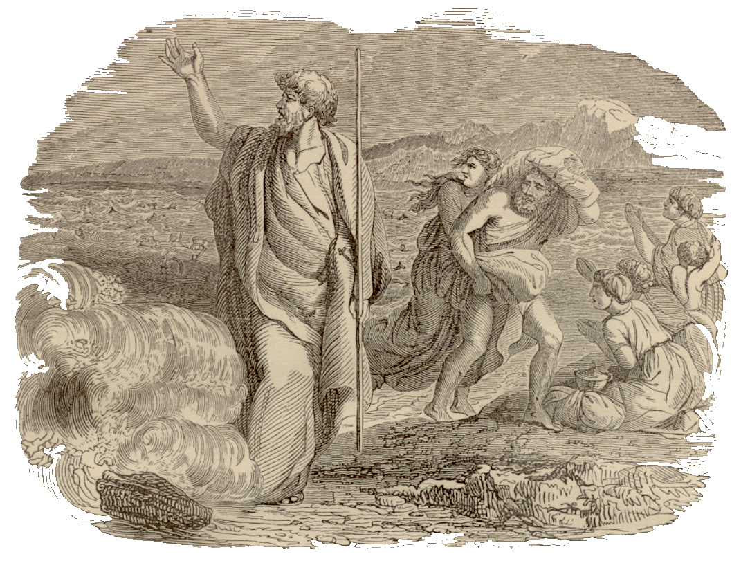
One of the most inspiring aspects of the Exodus account is Israel’s crossing of the Reed Sea (Yam Suph). I think all of us in some manner, when we picture this event, see Moses standing at the edge of a vast body of water, his arms and staff held high, the rushing torrents of the sea splitting from one shore of the Reed Sea to the other, then miraculously the two vast walls of water stand suspended, down the center of this sheer canyon hall the Israelites walked safely to the other side.
(Authors Note: This is an ongoing series exploring the location of Mount Sinai and the Red Sea Crossing. For those just joining the discussion I’d encourage you to read Part I & Part II of this series, it provides important context to this subject. Additionally Joel Richardson author of Mount Sinai in Saudi Arabia: The True Location of Revealed who’s book we have been exploring in this series has graciously taken time to offer his thoughts and corrections to Part I of my article. You’ll find his thoughts in the comment sections, so be sure to check that out as well. Additionally many of you have written in and offered comments, suggestions, and criticisms. I thank you. I’m not ignoring you, I’m trying to work through the backlog comments and emails and I will respond it just may take me awhile. Thank you for your understanding.)
The irony of this picture is that such a vision of events must disregard the plainly stated facts in favor of a poetic version. In essence, we must claim the following passage is not to be taken literally.
And Moses stretched out his hand over the sea; and YHWH caused the sea to go back by a strong east wind all that night, and made the sea dry land, and the waters were divided. And the children of Israel went into the midst of the sea upon the dry ground: and the waters were a wall unto them on their right hand, and on their left. (Exodus 14:21-22)
The above passage tells us that an East wind blowing all night caused the Reed Sea to be parted. If you believe as many do, that the Reed Sea crossing took place in the gulf of Aqaba at Nuweiba beach then there is simply no way for the above passage to be taken literally. There is no force of wind on earth strong enough to divide the 10 miles of the Gulf of Aqaba which reaches a depth of just over 2500 feet in the waters off Neweiba.
Keep in mind, that this wind was blowing all night long directly towards the Israelites. We can’t even claim the pillar of smoke and fire protected Israel from the wind, because that pillar was between Israel and the armies of Pharaoh.
The bottom line is, that if we are to believe that the Israelites crossed through the Gulf of Aqaba, we are compelled to disregard a plainly stated version of the events in favor of a poetic version. Is this proper exegesis of the text? I personally don’t think so but let’s explore the events related to the Reed Sea crossing get a clearer picture of what transpired.
Timing the Reed Sea Crossing
In Exodus 14, there are some fascinating clues which provide us with a timeline of events related to the Reed Sea Crossing. With these clues we can get a pretty good idea of what part of the day Israel entered the Reed Sea as well as when the armies of Pharaoh were drowned. This information will go along way to helping us understand the type of obstacle Israel encountered when they crossed the Reed Sea.
First we need to understand a little bit about how the Bible divided the nighttime portion of the 24 hour period of time we call a day. In Biblical times the night was divided into four periods of time (sometimes only three) called “watches”. These so called watches were roughly divided by our modern method of reckoning of time as follows:
- 1st Watch = 6-9 pm (evening watch)
- 2nd Watch = 9-12 pm (midnight watch)
- 3rd Watch = 12-3 am (cock-crow watch)
- 4th Watch = 3-6 am (morning watch)
Exodus 14:21-22 tells us that a “strong east wind” blew all night long. For the sake of this example let’s assume that “all night” meant the wind blew from 6pm (sundown) until 3am or from the evening watch until the cock-crow watch (about 9 hours). Exodus 14:24 tells us that sometime during the “morning watch” the Egyptians had followed the Israelites into the waterless bed of the Reed Sea. Then Exodus 14:27 tells us that when the morning (Hebrew boqer = break of day) appeared, the sea had returned to its normal “strength”.
And the Egyptians pursued, and went in after them to the midst of the sea, even all Pharaoh’s horses, his chariots, and his horsemen. And it came to pass, that in the morning watch YHWH looked unto the host of the Egyptians through the pillar of fire and of the cloud, and troubled the host of the Egyptians, And took off their chariot wheels, that they drave them heavily:…
…and YHWH said unto Moses, Stretch out thine hand over the sea, that the waters may come again upon the Egyptians, upon their chariots, and upon their horsemen. And Moses stretched forth his hand over the sea, and the sea returned to his strength when the morning appeared; and the Egyptians fled against it; and YHWH overthrew the Egyptians in the midst of the sea. (Exodus 14:23 – 27 excerpted)
But the children of Israel walked upon dry land in the midst of the sea; and the waters were a wall unto them on their right hand, and on their left. (Exodus 14:29)
So putting this information in its most natural and reasonable sense, we learn that a east wind blew the Reed Sea back all night until the morning watch. No more than three hours later by the break of day the Reed Sea had returned to its normal level. Within this three hour window of time every man, women, and child of Israel (not to mention all the livestock) had crossed the Sea and Pharaoh’s chariots and horsemen had reached the “midst” of the Reed Sea under heavy duress from Yahweh.
And the Egyptians pursued, and went in after them to the midst of the sea, even all Pharaoh’s horses, his chariots, and his horsemen. And it came to pass, that in the morning watch YHWH looked unto the host of the Egyptians through the pillar of fire and of the cloud, and troubled the host of the Egyptians,… (Exodus 14:23-24)
If Israel’s multitudes (2 million + livestock) crossed the Reed Sea in a column ½ mile wide, in the most optimistic scenario, it would have taken an hour before the last Israelite had even started their journey across the Reed Sea. Under this scenario the crossing (wherever it took place) had to have been accomplished by the Israelites in less than two hours. Further, this means that the Egyptians didn’t enter the Reed Sea until at least the 2nd or 3rd hour of the morning watch.
A Bit of Arizona Grand Canyon Perspective
Many of you have probably visited the Grand Canyon of Arizona at some point in your life. On average the Grand Canyon is 10 miles wide and nearly a mile deep. I am sure that some of you have been in awe of this majestic vista when you viewed it for the first time. Words do not adequately convey its grandeur nor is it a sight easy to forget.
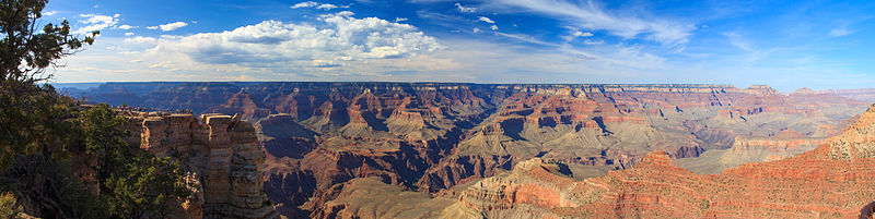
Courtesy of Wikipedia
Now picture in your mind a canyon half as deep as the Grand Canyon, but the same distance across and filled with water to its very brim. That’s the gulf of Aqaba at Newibea beach. If you believe that Israel crossed the Gulf of Aqaba at Newibea beach then you must also believe that somehow in two hours or less nearly 2 million people and an enumerable number of livestock crossed this 2500’ deep chasm nearly as wide as the Grand Canyon. To put that in a little bit better perspective, that crossing by Israel would be the same a taking every living soul in Tucson & Phoenix (Arizona’s two largest cities) and getting them across the Grand Canyon (half as deep) in two hours or less. That doesn’t even account for the additional mile of elevation change (2500’ down and 2500’ back up) nor any ravines, canyons, or other obstacles encountered along the way. This explanation demands that we as Bereans suspend disbelief and disregard nearly all the plainly stated chronological facts of the crossing in favor of a version of events which are physically impossible.
I should make clear here, that I have no problem believing in miracles. I believe, Yeshua literally turned water into wine, raised the dead, and walked on water of the Galilean Sea. He did indeed transcend, what we understand to be the natural laws of “nature”. And to be clear, there are many other examples of such occurrences throughout the Bible.
That being said, taking plainly stated reasonable facts from the Biblical account and rendering them into a version of events that requires miracles where natural events were described, in my opinion, undermines the credibility of the Biblical account. Further, it requires us to view those plainly stated facts as errors and replace those erroneous facts with poetic license. Let me give a few examples why literal verses poetic context is so important.
The Walls of Water
I know many believe that only a deep water crossing satisfies the description of the walls of water that constrained the Israelites as they crossed the Reed Sea. But is this view Scriptural or more a product of sensationalism? Let’s explore this subject some. Here is Mr. Richardson’s take on the subject:
The Bible doesn’t allow us to reimagine this event as some otherwise naturally occurring phenomenon that the Lord caused to happen at just the right moment. Those who seek to do so tend to only emphasize the blowing of the “strong east wind,” while minimizing many of the other references found throughout Scripture. Among these descriptions are the references to the high walls of water that formed on either side of the Israelites. As Douglas Stuart, Old Testament professor at Gordon-Conwell Theological Seminary, rightly states:
The text, however, says that the wind actually pushed one part of the sea away from the other part (“drove the sea back . . . the waters were divided,” v. 21) and created a “wall of water on their right and on their left.” The term used for “wall” here, hōmāh, connotes a very large wall—not a small stone wall or retaining wall but always a massively large (usually a city) wall, towering above the Israelites, who marched on dry land with walls of water on either side of them. It is clear from the descriptions given that the sea through which the Israelites walked was deep water, not something shallow. A city-wall sized wall of water on either side of them implies the division of a deep body of water, not merely the drying out of a shallow one or the drying out of wet terrain. Even the use of the term yam (“sea”) here implies the depth of the water. Yam is never used for swamps or mud flats but is used consistently to describe large bodies of water (what we would call either lakes or oceans).Richardson, Joel. Mount Sinai in Arabia: The True Location Revealed (Kindle Locations 342-353). WinePress Media. Kindle Edition.
As we learned in Part II (here) of this study Mr. Stuart as quoted above is incorrect in his claims here about the word Yam. Yam is in fact used to describe the shallow bronze “sea” made for Solomon’s temple. Yam is also used to describe the tongue of the Egyptian Sea (Heroopolictic gulf or gulf of Suez), which in ancient times extended all the way up to the Bitter Lakes region.
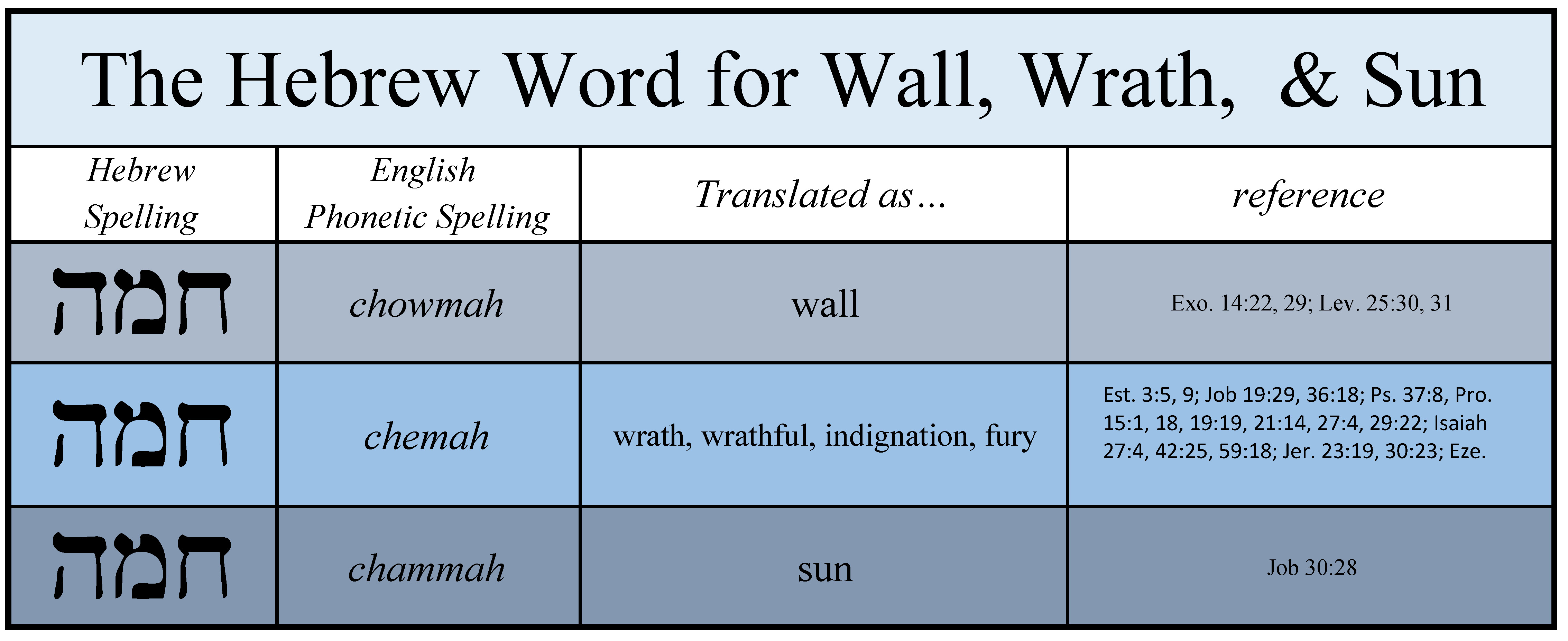
Further, Stuart, as quoted above, is wrong on two accounts about homah (chomah), the Hebrew word for “wall”. First of all, the Hebrew word for “wall” as given in Exodus 14 is not “always” used to describe a “massively large (usually a city) wall…” as he stated. In Samuel 25:16 a form of the word is used to describe David’s men as a wall unto men of Nabal. In the Song of Solomon, the same word is used to figuratively describe a young girl.
Secondly, and more to the point, the actual form of the Hebrew word for “wall” as found in the Exodus 14 account is used more often to describe wrath, fury, and indignation (mostly Yahweh’s) than it is used to describe a wall. You see, this form of the word is a bit more nuanced than the English version of the text suggests. The Hebrew word has at least three different meanings, they are: Wall, wrath/fury/indignation, and sun.
Interestingly the different meanings of this word as given in the Hebrew and English version of our Bibles are based upon the vowel pointings or cantilation marks added by the Mesoretes in the Middle Ages. In other words, as the chart below reflects, the Mesoretes added their own interpretational bias to the Hebrew word to provide it with what they thought was the best meaning of the word as given in the context of the Hebrew passage where it was found.
Were the Mesorets correct, when they gave the meaning “wall” to the text in Exodus 14? As a layman, it looks that way to me. But the fact of the matter is, this Hebrew word may well have had deeper richer more nuanced meaning when given in the Exodus account. Here see what you think:
When the Walls Came Crashing Down
In any case, to the Israelites those walls of water (whatever their height) were indeed a deliverance from certain death, but to the Egyptian’s armies those walls of water were nothing less than the instruments of Yahweh’s righteous indignation directed towards the oppressors of His chosen people.
From a practical standpoint the Egyptians could have drowned in less than 8 feet of water. To satisfy the literally meaning of wall here in the text of Exodus 14 does not require 2500′ walls of water.
Anyone who has seen the destructive force of a flashflood or tsunami first-hand knows the chances of surviving such a force coming at you from two directions at the same time, while you are in the “midst” of a sea (whatever its depth), are slim to none . When that East wind stopped pushing the waters of the Reed Sea to the North and South, those waters would have come rushing back as two raging walls picking up dirt, rocks, and other debris along the way.
To give you a practical understanding of the force involved, the average flash flood travels at 7-10 miles per hour and a tsunami at 10-20 miles an hour. At ten miles per hour water exerts more force that a 250 mph wind.
In either case, if you were the Egyptians, it would have been a truly fearsome sight to see and hear those walls of water 30, 20, or even 10 feet high – miles up the bed of the Reed Sea come rushing back towards you at 10 or 20 mph, all the while you, trapped right in the midst of that sea with no possibility of reaching the shore, stood in terror as those walls of water enveloped you.
Sunk to the Bottom of the Sea
This leads to another point often brought up, when discussing this subject. In Exodus 15, Moses, upon Israel’s safe crossing of the Reed Sea and the destruction of Pharaoh’s army, sings a song of praise unto Yahweh. In that song, Moses describes Yahweh’s parting of the Reed Sea as a blast of His nostrils and Pharaoh’s army is described as sinking into the depths of the sea.
Both of these descriptions are often used (by those who believe in a Gulf of Aqaba crossing) as proof that the body of water crossed by the Israelites must have been a deep body of water and thus the Heroopolis Gulf (Suez) of the Red Sea or as Isaiah described it the “tongue” of the Egyptian Sea would not qualify.
The context here should not be forgotten. Moses in Exodus 15 is singing a poetic song of praise to Yahweh. Such poetry is not bound by a strictly literal interpretation of events. The Egyptians sinking into the depths of the sea is a perfect example of such poetry.
Unless Pharaoh’s chariots were equipped with water skis and Pharaoh’s horses could walk on water, they didn’t literally sink into the depths of the Reed Sea, they were already there! When they were consumed by those raging walls of water they were already standing on the dry bed of the Reed Sea.
The Song of Solomon
In case you need further convincing there are some examples of poetic license in the Bible which were never intended to be taken in a strictly literal sense. Some of the Bible’s most extravagant poetry is found in the Song of Solomon like the following passage, where the prince’s daughter is described:
The Song of Solomon –
Thy neck is as a tower of ivory; thine eyes like the fishpools in Heshbon, by the gate of Bathrabbim: thy nose is as the tower of Lebanon which looketh toward Damascus…
This thy stature is like to a palm tree, and thy breasts to clusters of grapes. (Song of Solomon 7:4-7)
No reasonable student of the Bible takes these descriptions in their most literal sense. Why then should we demand that the Song of Moses in Exodus 15 be taken in a strictly literal sense, especially when that requires us to discard the most natural and reasonable description of events given in Exodus 14? Here is an excerpt of Moses’ song for comparison. As you read it really think about what Moses meant to be taken literally and what he intended to be poetic.
The Song of Moses –
Then sang Moses and the children of Israel this song unto YHWH, and spake, saying, I will sing unto YHWH, for he hath triumphed gloriously:
…the horse and his rider hath he thrown into the sea.
… Pharaoh’s chariots and his host hath he cast into the sea:
…depths have covered them: they sank into the bottom as a stone
…thy right hand, O YHWH, hath dashed in pieces the enemy.
…thou sentest forth thy wrath [charown], which consumed them as stubble.
…And with the blast of thy nostrils the waters were gathered together,
…the floods stood upright as an heap,
…and the depths were congealed in the heart of the sea.
…Thou didst blow with thy wind, the sea covered them:
… they sank as lead in the mighty waters.
(Exodus 15:1-10 excerpted)
As you can see here, Moses is clearly using poetic language to describe the real events of the Reed Sea crossing. To demand that this description of the events be taken in its most literal sense, in my opinion is not reasonable exegesis of the text.
One aspect of this Song I’d like to bring your attention to is the description of the destruction of Pharaoh’s armies by the waters of the Reed Sea as a result of Yahweh’s wrath – his charown.
It is hard to dismiss as coincidence that the Hebrew word for those destructive “walls” of water in Exodus 14 is also used in the Bible to describe Yahweh’s wrath, indignation, and fury. It is truly a fearful thing to fall into the hands of an angry God.
Chemah indeed!
Behold, a whirlwind of YHWH is gone forth in fury [chemah], even a grievous whirlwind: it shall fall grievously upon the head of the wicked. Jeremiah 23:19
Was Josephus Right or Wrong?
Over the years as I’ve tried to untangle some of the claims and counter claims regarding the location of the Reed Sea crossing and Mount Sinai, an account describing the topography near the Reed Sea crossing by the first century Jewish historian Josephus keeps coming up. Mr. Richardson gives a good example of how many of his peers view Josephus’ account:
Josephus’s Reed Sea
Outside of the Bible, further evidence for the crossing at the Gulf of Aqaba may be found in the testimony of Josephus, the first-century Jewish historian. Josephus specifically describes the location of the miraculous sea crossing as having been closely surrounded on both sides by impassably tall and rugged mountains: (Richardson, Joel. Mount Sinai in Arabia: The True Location Revealed (Kindle Locations 473-476). WinePress Media. Kindle Edition.)
For further reference here is Josephus’ account:
Now when the Egyptians had overtaken the Hebrews, they prepared to fight them, and by their multitude they drove them into a narrow place; for the number that pursued after them was six hundred chariots, with fifty thousand horsemen, and two hundred thousand footmen, all armed. They also seized on the passes by which they imagined the Hebrews might flee, shutting them up {b} between inaccessible precipices and the sea; 325 for there was on each side a ridge of mountains that terminated at the sea, which were impassable by reason of their roughness, and obstructed their flight; therefore they pressed there upon the Hebrews with their army, where [the ridges of] the mountains were closed with the sea; which army they placed at the pass where the mountains abuts the sea, that so they might deprive them of any passage into the plain. (Antiquities of the Jews 2:324-325)
What most commentators don’t tell you is, that Josephus limits this location to the “third day” from Israel’s departure from Ramsees. Those like Mr. Richardson, who do mention the chronological limiting statements of Josephus often dismiss Josephus’ statements as errors. Here is how Mr. Richardson explains this conundrum:
Some have objected to using Josephus as a support for an Aqaba crossing because elsewhere he states that the journey out of Egypt to the Yam Suph took only three days.15 Josephus’s error is likely because he determined the time it took to reach the Yam Suph by assuming that the Israelite’s two encampments meant two nights at camp and three days of actual travel. His erroneous calculations, however, do not do away with the fact that he viewed the sea crossing to be at Aqaba. (Richardson, Joel. Mount Sinai in Arabia: The True Location Revealed (Kindle Locations 485-490). WinePress Media. Kindle Edition.)
To cherry pick the evidence in this way leaves a big credibility gap. Either Josephus had a good idea of what happened and where it happened or his account is hopelessly flawed and none of it should be trusted. In my opinion, if we are going to use Josephus’ accounts as part of our evidence for the location of the Reed Sea crossing then we must make a reasonable effort to include all his chronological and geographical statements into the matrix. Absent additional clarifications from Josephus’ own writings we do not have the luxury of picking and choosing the part of his account we want to believe.
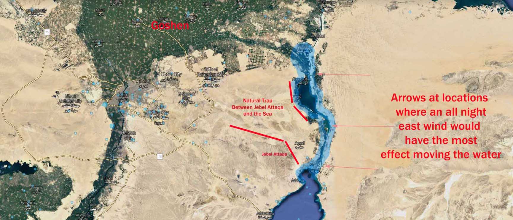
Below are several maps showing the topography of Egypt, the Reed Sea, and the only geographical features that might be considered “mountains” within a “third day” journey from Ramses/Goshen. Keep in mind as you look at these maps, that they do not account for nearly 3500 years of erosion nor the leveling/construction efforts of the Egyptians. (For example the ridges along Wady Tumilat which are heavily populated today). You can draw your own conclusions as to whether Josephus’ account is credible or not.
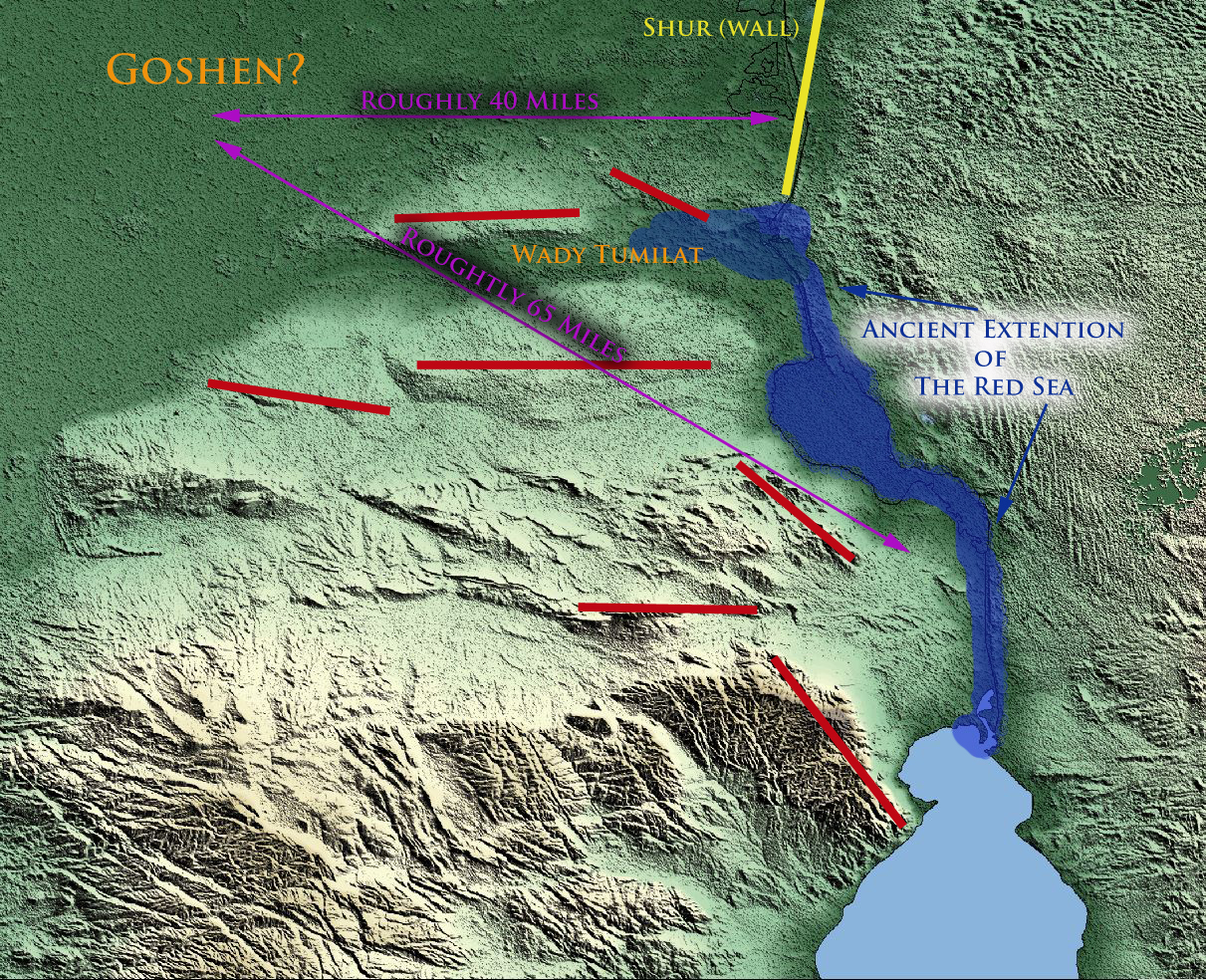
Red bars indicate hills, ridges, and cliffs.
Courtesy Google Maps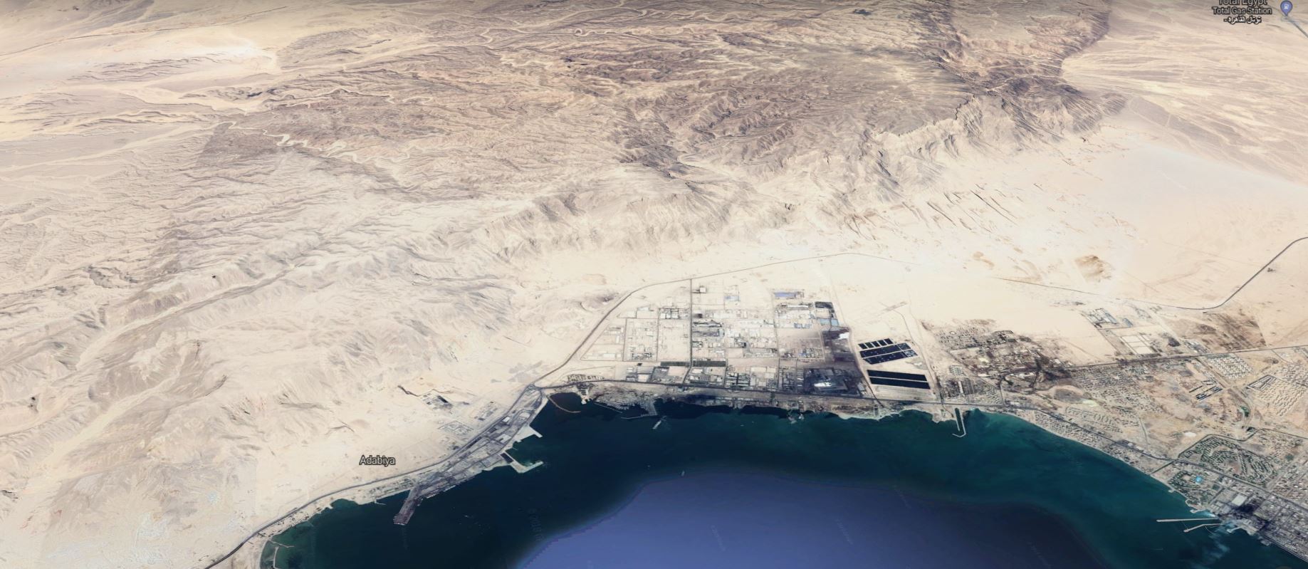
[DISPLAY_ULTIMATE_PLUS]
Courtesy Google Earth Maps – Showing the once extensive cliffs of Jebel Attaga and 3500 years of erosion
So the Hebrews went out of Egypt, while the Egyptians wept, and repented that they had treated them so harshly. Now they took their journey by Letopolis, a place at that time deserted, but where Babylon was built afterward, when Cambyses laid Egypt waste: but as they went away hastily, on the third day they came to a place called Baalzephon, on the Reed Sea; (Antiquities of the Jews 2:315)
…and they [the Egyptians] thought they should easily overcome them, as they had no armour, and would be weary with their journey; so they made haste in their pursuit, and asked of everyone they met which way they were gone. And, indeed, that land was difficult to be travelled over, not only by armies, but by single persons. As also he led them this way on account of the Philistines, who had quarrelled with them, and hated them of old, that by all means they might not know of their departure, for their country is near to that of Egypt; (Antiquities of the Jews 2:321-322)
Why is Saudi Arabia and the Gulf of Aqaba So Attractive
One of the things that makes the Gulf of Aqaba crossing and the mountains of Saudi Arabia so attractive as the location of the Reed Sea crossing and Mount Sinai, are some of the anecdotal claims (historical and geographical) made about the area and its history. Let’s look at some of those claims.
Where was the Midian Homeland of Jethro and Moses?
A confusing aspect of this discussion is the question of the location of the Midian homeland of Jethro and Moses. Unfortunately, this specific question gets confused with the more general question of the boundaries of ancient Midian territory.
According to the Biblical text, the Midianites were ruled by several kings or princes. In the Biblical record, these kings often banded together to attack Israel or defend their own territory. In any case, there is no indication from the Biblical text that there was a single capital city of Midianites, nor is there any indication in the Bible (that I’m aware of) that Jethro (Reuel) was associated with any particular city of the Midianites.
This is important to keep in mind. Jethro was a priest or prince of the Midianites, but he also had flocks of sheep. In a desert environment, those who shepherd flocks must continually move their flocks in order to find them food and so that the ground does not become overgrazed. This would have required a nomadic lifestyle. In Jethro’s case, it was his daughters who shepherded his flocks. It’s also worth mentioning that at their initial encounter with Moses, the particular watering hole was used by other (Midianite?) shepherds.
A City or Territory?
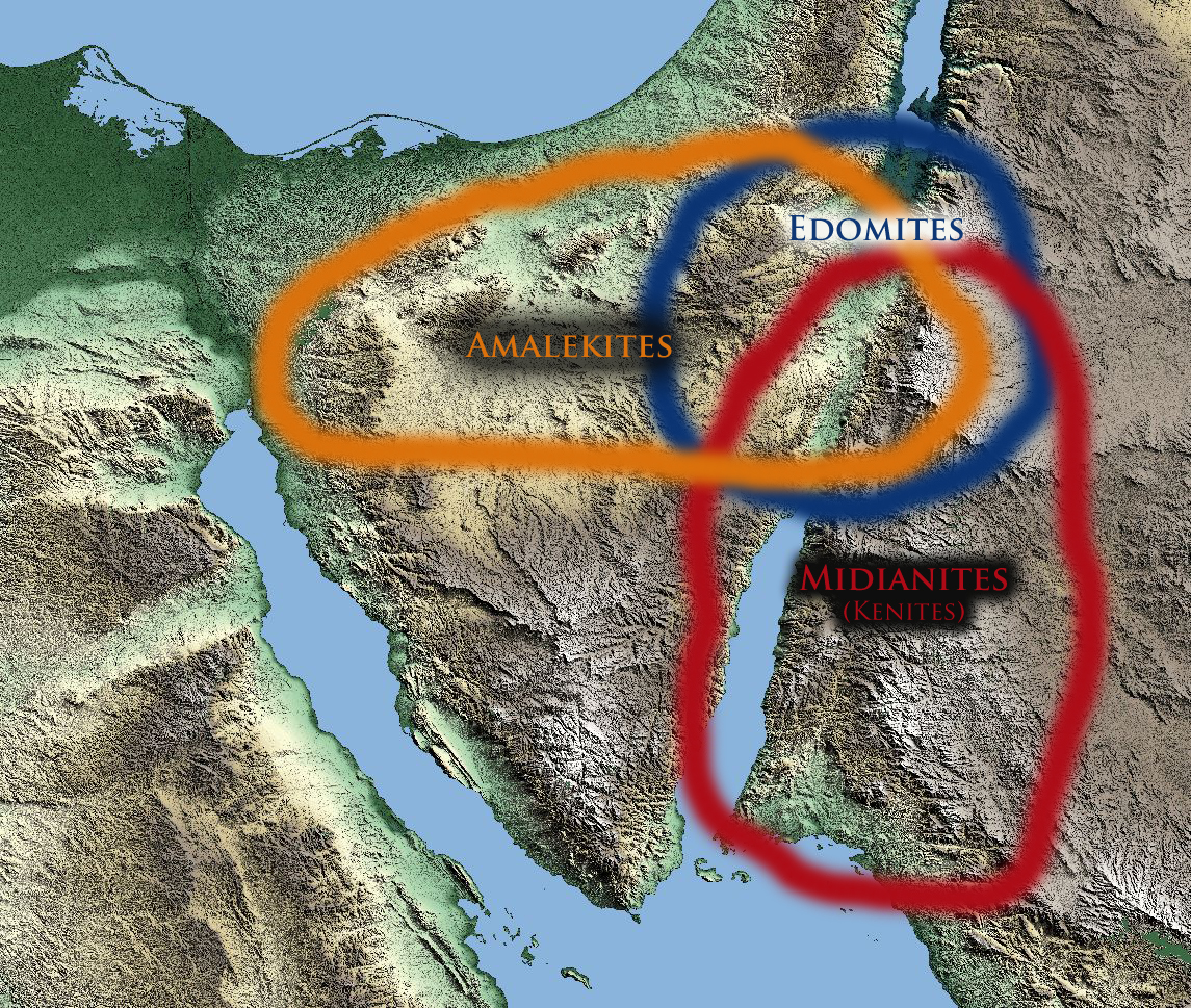
Take a look at the map below. The map provides a rough idea of the territory of the Midianites based upon Biblical and historical sources. As you can see, Midianite territory was a rather large expanse, the borders of which varied over the centuries as they lost or gained land based upon conquest and defeat. There wasn’t just one capital city of the Midianites, as stated above the Midianites were ruled by several kings. If Jethro was associated with a city of the Midianites, what Biblical facts allow us to assume that Jethro was associated with the ancient city of Madian/Madiam/Midiam, the city known today by the name of al-Bad?
Joel Richardson sums up this challenge in the following quote from Chapter 5 of his book:
Beyond being east of the Gulf of Aqaba, the Bible gives us a second critical witness regarding the location of Mount Sinai. As we will see, Scripture describes Mount Sinai as being either within the territory of, or beside the land of Midian. Thus, determining where Midian was located is essential. (Richardson, Joel. Mount Sinai in Arabia: The True Location Revealed (Kindle Locations 535-537). WinePress Media. Kindle Edition.)
In the following passage Mr. Richardson goes on to argue against the traditional site of Mount Sinai by claiming that the city of al-Bad (the ancient location associated with Madian/Madiam/Midiam) was the ancient capital of the Midianites.
Some have suggested that because many translations place Sinai west of Midian, this rules out Jebel al-Lawz as it is roughly twelve to fifteen miles east of the ancient capital city of Midian, now called al-Bad. This argument has also been used to support the traditional site, pointing out that it is indeed to the west of Midian. The obvious problem of course is that Moses did not place Jethro’s flocks on a boat and sail west across the Gulf of Aqaba. Instead, if he had gone to the traditional site, he would have had to have traveled well over a hundred miles north, then over another hundred miles southwest to reach the mountain. (Richardson, Joel. Mount Sinai in Arabia: The True Location Revealed (Kindle Locations 557-561). WinePress Media. Kindle Edition.)
There is certainly no indication within the text that Moses traveled through multiple deserts, through the territories of multiple foreign peoples to reach the mountain. (Richardson, Joel. Mount Sinai in Arabia: The True Location Revealed (Kindle Locations 568-569). WinePress Media. Kindle Edition.)
There are several difficulties with Mr. Richardson’s claims above.
First, if you are not careful you might miss the fact that Mr. Richardson inserts an unproven assumption into his arguments, which assumption he then uses as proof that the Sinai Peninsula could not have been the true location of Mount Sinai. In the passage above Mr. Richardson conflates “Midian” the territory with “Midian” the city. He then goes on to claims this location as the ancient capital of the Midianites and the implied home of Jethro and Moses. I can see no way to make such a determination from the Biblical text. Take a look for yourself:
Now when Pharaoh heard this thing, he sought to slay Moses. But Moses fled from the face of Pharaoh, and dwelt in the land of Midian: and he sat down by a well.
Now the priest of Midian had seven daughters: and they came and drew water, and filled the troughs to water their father’s flock. And the shepherds came and drove them away: but Moses stood up and helped them, and watered their flock. And when they came to Reuel their father, he said, How is it that ye are come so soon to day? And they said, An Egyptian delivered us out of the hand of the shepherds,…
And Moses was content to dwell with the man: and he gave Moses Zipporah his daughter…
Now Moses kept the flock of Jethro his father in law, the priest of Midian: and he led the flock to the backside of the desert, and came to the mountain of God, even to Horeb. (Exodus 2:15 – 3:1 excerpted for brevity)
As you can see from the above text, there is no basis to claim that the “land of Midian” refers to an ancient capital city of Midian. Midian is first described as a “land” or territory. At no point in the text does it clearly transition to a specific city in the land of Midian, let alone a city named “Midian”.
This means that any (Biblcial) argument that uses “Midian” the territory as toponym for “Midian” the city is purely speculative and without Biblical support. Further, any argument that depends on this city of “Midian” as it relates to a specific geographical location is also speculative and must be considered with caution.
I can’t help but wonder why Jethro couldn’t have been a priest or prince of some northern part of Midianite territory? If Jethro was indeed associated with a particular city, (which the Bible does not clearly indicate) why couldn’t that city have been in the northern parts of Midianite territory, where it overlapped with the Edomites and Amalekites?
Consider the following passages that indicate the Midianites (a.k.a. Kenites or Shechemites) dwelt in the general area of northern Midian territory and southern Israel. Also note, the Kenites according to the book of Samuel and the account of Josephus, dwelt in the midst of the Amalekites which at that time was southern Israel. Also consider that the Kenites weren’t just a branch of Midianite descendants from Jethro, but were also a people present in the land when Yahweh promised to Abraham that his seed would someday inherit their land. (see Gen. 15:14 below).
To me at least, this seems to suggest that Jethro and his descendants occupied the northern part of the Midianite kingdom.
In the same day YHWH made a covenant with Abram, saying, Unto thy seed have I given this land, from the river [nahar] of Egypt unto the great river, the river Euphrates: The [land of the] Kenites, and the Kenizzites, and the Kadmonites,… Genesis 15:18-19
And the children of the Kenite, Moses’ father in law, went up out of the city of palm trees with the children of Judah into the wilderness of Judah, which lieth in the south of Arad; and they went and dwelt among the people. (Judges 1:16)
Now Heber the Kenite, which was of the children of Hobab the father in law of Moses, had severed himself from the Kenites, and pitched his tent unto the plain of Zaanaim, which is by Kedesh. 12 And they shewed Sisera that Barak the son of Abinoam was gone up to mount Tabor. (Judges 4:11-12)
And Moses said unto Hobab, the son of Raguel the Midianite, Moses’ father in law, (Numbers 10:29)
And Saul said unto the Kenites, Go, depart, get you down from among the Amalekites, lest I destroy you with them: for ye shewed kindness to all the children of Israel, when they came up out of Egypt. So the Kenites departed from among the Amalekites. 7 And Saul smote the Amalekites from Havilah until thou comest to Shur, that is over against Egypt. 8 And he took Agag the king of the Amalekites alive, and utterly destroyed all the people with the edge of the sword. (1 Samuel 15:6-8)
But when Saul had conquered all these Amalekites that reached from Pelusium of Egypt to the Red Sea, he laid waste all the rest of the enemy’s country: but for the nation of the Shechemites, he did not touch them, although they dwelt in the very middle of the country of Midian; for before the battle, Saul had sent to them, and ordered them to depart from there, lest they should be partakers of the miseries of the Amalekites; for he had a just occasion for saving them, since they were of the kindred of Raguel, Moses’ father-in-law. (Antiquities of the Jews 6:140)
From Arabia to the Wall of Egypt
By the way, did you note in 1 Samuel 15:6-8 above, that it indicates that Amalekite territory extended from Hivilah (a place in Arabia) unto the Shur (wall) that is over against Egypt. Fascinating, isn’t it, that there was a place in or by the border of Egypt called the “Wall”. As we learned in Part I & Part II of this series Egypt’s northeastern frontiers at the time of the Exodus were indeed protected by such a shur or wall. Naturally any “wilderness” inside or outside that Shur would have been called the “wilderness of Shur” or the Wilderness of the Wall. Pretty neat stuff!
The Journeys of Moses
Based upon the assumption that Midian was a city (not a territory), and the further assumption that Moses fled to this ancient capital city or the area surrounding it, Mr. Richardson puts forth an argument that the distance from Midian (the city) to Mount Sinai (traditional location) was too great for Moses to take Jethro’s flock there to graze. He argues as follows:
One could very reasonably say that Moses walked fifteen or perhaps even as much as thirty or more miles to graze his flocks somewhere within Midianite territory, but 450 to 500 miles is an extreme stretch to say the least. Without the text directly stating that Moses went on such an incredibly extended journey, we have no basis to make such claims. This problem is greatly amplified when many years later, Jethro visited Moses and all of Israel as they were camped at the mountain: (Richardson, Joel. Mount Sinai in Arabia: The True Location Revealed (Kindle Locations 573-577). WinePress Media. Kindle Edition.)
In my opinion there are several problems with this statement.
First of all, it seems rather incongruent to make the argument that it is an “extreme stretch” for one man and his flocks to have made the journey from Midian (the city) all the way to Mount Sinai in the Sinai Peninsula. Yet, Mr. Richardson indicates that he believes it utterly reasonable for the entire host of the Children of Israel, their sheep, and other livestock to make the equally difficult and lengthy journey from Egypt to area around Midian (the city).
Second, arguing against the traditional Sinai (or any Sinai) location, based upon unproven assumptions about Midian (the city) and Jethro’s & Moses’ relationship to that city is a speculative exercise that only confuses the subject.
Third, the above argument used by Mr. Richardson assumes that the traditional location of Mount Sinai is the only option to consider. If Mt. Sinai was further North, as some scholars suggest, and Jethro’s shepherding was in the northern part of Midianite territory, many of the challenges to Moses’, Jethro’s and Israel’s itineraries would disappear.
My point here is, that any exploration of this subject needs to consider all the available facts without unhelpful and misleading arguments that only support a single line of investigation. This is a fascinating and complex subject and a reasonable and balanced approach (in my opinion) is the best way to work out the complexities.
The Territory of Midian in Summary
In summary, the above evidence suggests that Midianite territory included the area around the northern part of the Aelantic Gulf (Aqaba) including parts of what is known today as southern Israel. In my opinion, the most reasonable rendering of the available facts suggests, that it was this part of Midianite territory to which Moses fled when leaving Egypt. Further, it provides a more central location from which the events described likely took place.
Who Was Shuaib?
This leads to a related subject concerning Jethro, the father in-law of Moses. One of anecdotal claims often stated as evidence that Jabal al-law and the mountains of Arabia are the real Mount Sinai is the so called “cave of Jethro”. Mr. Richardson explains it this way:
The Caves of Jethro
Several very important archeological sites in al-Bad are closely associated with Moses or his father-in-law Jethro, who the Muslims call Shuaib (transliterated variously as Shuy’ib, Sho’aib, or something similar). In fact, another name for al-Bad is Muhgair al-Shuaib, which means, the “Caves of Jethro.” At the center of this small town is a cluster of caves hewn into the hillside that are believed to be the ancient home of Jethro and Moses. (Richardson, Joel. Mount Sinai in Arabia: The True Location Revealed (Kindle Locations 690-694). WinePress Media. Kindle Edition.)
I think it should be noted here, that association between Shuaib and Jethro is unproven historical speculation and without any Biblical merit. Mr. Richardson is mistaken in his claim (above) that Muhgair al-Shuaib means “Caves of Jethro” this is simply not accurate. Muhagair al-Shuaib in Arabic simply means the Cave of Shuaib.
Name meanings:
- Shuaib = “who shows the right path”
- Jethro = “his abundance”
- Reuel (Jethro) = “friend of God”
A few other interesting anecdotes about Shuaib are worth noting. While Muhammad Ibn Ishaq, the 8th century Islamic historian, claims that Shuaib’s name translated in Syrian is Yahrun (Jethro), classical Islamic scholar Ibn Kathir Shu’ayb seems to contradict this by claiming that (Shuaib) prophesied to the Madyan people four generations after Abraham. (This would place him several centuries before the time of Moses and Jethro.) Neither historian provides any more context for their claims (that I could find).
Further, Islamic tradition also states that Shu’aib was sent to Madyan to tell them to repent of their evil. This implies that he did not live there. If indeed Madyan is the present day al-Bad, the fact there is a “cave of Shu’aib” near al-Bad does not prove that this was Shu’aib’s home town. After the people of Madyan refused to listen to Shu’aib, Islamic tradition claims that Allah sent judgment to destroy the Madyan people. According to tradition Shu’aib was not present when that judgment fell.
It should also be noted that Arabic traditions places the tomb of Shuaib in Jordan, lower Galilee or by some accounts the Sinai Peninsula. No tradition, that I’m aware of, places Shuaib’s tomb in the ancient city of Madyan (present day al-Bad).
The following are Quaranic references to Shu’aib:
[7:85] And to Madyan (We sent) their brother Shu’aib. He said: O my people! Serve Allah, you have no god other than Him; clear proof indeed has come to you from your Lord, therefore give full measure and weight and do not diminish to men their things, and do not make mischief in the land after its reform; this is better for you if you are believers:
[11:84] And to Madyan (We sent) their brother Shu’aib. He said: O my people! Serve Allah, you have no god other than He, and do not give short measure and weight: surely I see you in prosperity and surely I fear for you the punishment of an all-encompassing day.
[29:36] And to Madyan (We sent) their brother Shuaib, so he said: O my people! Serve Allah and fear the latter day and do not act corruptly in the land, making mischief. [29:37] But they rejected him, so a severe earthquake overtook them, and they became motionless bodies in their abode.
Local traditions and toponyms notwithstanding, there is no real contextual Biblical or archeological evidence (that I’m aware of) to back up the claims that Madyan (the present day al-Bad) was the home of Jethro or even the general location where Moses fled to when he left Egypt.
The Borders of Israel and Egypt
The Exodus has so many interrelated topics and complexities. One which I had not been aware of until reading Mr. Richardson’s book was the subject of the borders of Israel and Egypt. In his book Mr. Richardson claims the “brook of Egypt” was the border of Egypt. Further, that this border extended to the Gulf of Aqaba arm of the Reed Sea. Mr. Richardson explains it this way:
The Border of Egypt
Before we conclude our discussion of what the Bible says on this matter, we must also consider another critical Scriptural proof for a crossing at the Gulf of Aqaba. The Bible is quite clear in defining the border of Egypt. It is “the Brook of Egypt, now known as the Wadi el-Arish, the natural boundary between the southwestern Negev and the northeastern Sinai Peninsula regions.”19 Wadi el-Arish is 140 miles east of Port Said, Egypt (the northern end of the Suez Canal) and thirty miles west of the Gaza Strip. (Richardson, Joel. Mount Sinai in Arabia: The True Location Revealed (Kindle Locations 499-504). WinePress Media. Kindle Edition.)
When the Lord defined the promised land to Abram, He defined it as extending “from the river of Egypt [in the southwest] as far as the great river, the river Euphrates [in the north]” (Genesis 15:18). In other passages, we find the terms “the river of Egypt” and “the border of Egypt” used interchangeably. (Richardson, Joel. Mount Sinai in Arabia: The True Location Revealed (Kindle Locations 504-506). WinePress Media. Kindle Edition.)
Second, when the Bible specifically mentions the location of the Red Sea, it is always beside the city of Eilat and the land of Edom. (Richardson, Joel. Mount Sinai in Arabia: The True Location Revealed (Kindle Locations 525-526). WinePress Media. Kindle Edition.)
I admit, I’d never heard of the “brook of Egypt” as defining the border of Egypt as explained by Mr. Richardson . As I’ve been researching these claims, there are several things which I believe need further explanation.
First of all, none of the passages regarding the “brook of Egypt” that I could find are actually used to specifically define the border of Egypt, but rather they define the border of Israel at specific times during their ongoing inheritance of the land. This is an important distinction to make, because Yahweh did not allow Israel to inherit all of the Promised Land at once but rather “little by little”. This means that the borders of Israel have and will continue to change until the coming of the Yeshua. Let’s explore this a bit more.
The Nile Is the Future Border of Israel
Let’s start by looking at the original promise Yahweh made with Abraham. As we unpack this, I think you’ll see another perspective on the subject. Here is Yahweh’s original land promise to Abraham concerning Israel’s future border with Egypt.
In the same day YHWH made a covenant with Abram, saying, Unto thy seed have I given this land, from the river [nahar] of Egypt unto the great river, the river [nahar] Euphrates: (Genesis 15:18)
Please note, that the word used here for river is nahar. This word is most often, though not exclusively, used to refer to the river Euphrates. It is also important here not to confuse the Hebrew word nahar (river) with the Hebrew word Nachal (river, stream, brook, wadi, or valley). The word nahar in the Bible seems to be used mostly to refer to substantial rivers, not streams or brooks.
In contrast, nachal has a wide range of meanings including: stream, (streams as a division of a nahar-river), brook, flood, valley, and inheritance. There is not one clear example (that I’m aware of) of nahar (river) being used to describe the “brook of Egypt”. On the other hand nachal is used in the Bible to describe the seven branches of the Nile River (nahar).
The following verses give you a sense of how nahar is used in reference to the Nile River.
And YHWH spake unto Moses, Say unto Aaron, Take thy rod, and stretch out thine hand upon the waters of Egypt, upon their streams [nahar], upon their rivers [ye’or = canals], and upon their ponds, and upon all their pools of water, that they may become blood; and that there may be blood throughout all the land of Egypt, both in vessels of wood, and in vessels of stone. (Exodus 7:19)
And YHWH spake unto Moses, Say unto Aaron, Stretch forth thine hand with thy rod over the streams [nahar], over the rivers [ye’or = canals], and over the ponds, and cause frogs to come up upon the land of Egypt. (Exodus 8:5)
And the Egyptians will I give over into the hand of a cruel lord; and a fierce king shall rule over them, saith the Lord, YHWH of hosts. And the waters shall fail from the sea, and the river [nahar] shall be wasted and dried up. And they shall turn the rivers [nahar] far away; and the brooks [ye’or = canals] of defence shall be emptied and dried up: the reeds and flags shall wither. The paper reeds by the brooks, by the mouth of the brooks, and every thing sown by the brooks, shall wither, be driven away, and be no more. (Isaiah 19:4-7)
And YHWH shall utterly destroy the tongue of the Egyptian sea; and with his mighty wind shall he shake his hand over the river [nahar] , and shall smite it in the seven streams [nachal], and make men go over dryshod. (Isaiah 11:15)
Regarding Mr. Richardson’s claim above, that the “border of Egypt” and “river [nachal] of Egypt” are used interchangeably, I cannot find any clear example of such a usage.
Borders and Inheritances
As I was examining the Scriptures related to “brook (Nachal) of Egypt”, I learned something rather interesting. Some of you may have been aware of this, but it was surprising to me. The Hebrew nachal doesn’t just refer to small rivers, streams, brooks, floods, or valleys. In the original Hebrew (without vowel pointings / cantilation marks) the word nachal is also used to describe Israel’s inheritance. Here take a look:
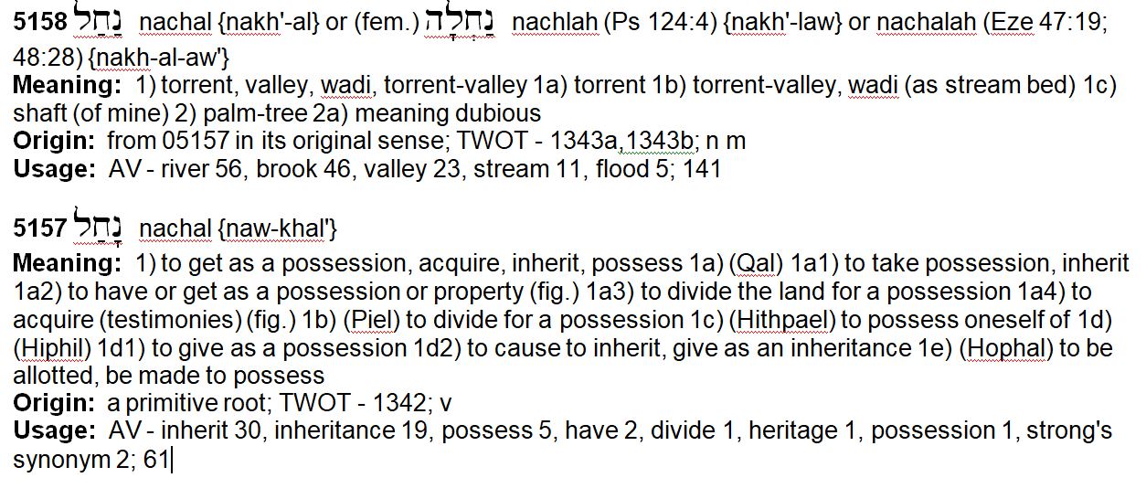
As you can see from the above definitions of the word Nachal, it can be used to refer to a brook, wadi, valley, stream, as well as a land/border inheritance. This makes me wonder if the verses which have been translated “brook of Egypt” might also have the underlying connotation of “inheritance” in Egypt as it relates to Yahweh’s promise to Abraham that his seed would inherit the land all the way to the nahar (Nile River) of Egypt. You might also make the argument that instead of “brook of Egypt” the passages could also read the “valley of Egypt”. Something worth considering at least!
And YHWH appeared unto him, and said, Go not down into Egypt; dwell in the land which I shall tell thee of: Sojourn in this land, and I will be with thee, and will bless thee; for unto thee, and unto thy seed, I will give all these countries, and I will perform the oath which I sware unto Abraham thy father; And I will make thy seed to multiply as the stars of heaven, and will give unto thy seed all these countries; and in thy seed shall all the nations of the earth be blessed; (Genesis 26:2-4)
I will not drive them out from before thee in one year; lest the land become desolate, and the beast of the field multiply against thee. By little and little I will drive them out from before thee, until thou be increased, and inherit [nachal] the land. And I will set thy bounds from the Red sea even unto the sea of the Philistines, and from the desert unto the river: for I will deliver the inhabitants of the land into your hand; and thou shalt drive them out before thee. (Exodus 23:29-31)
Also at the same time Solomon kept the feast seven days, and all Israel with him, a very great congregation, from the entering in of Hamath unto the river [nachal] of Egypt. (2 Chronicles 7:8)
Remember Abraham, Isaac, and Israel, thy servants, to whom thou swarest by thine own self, and saidst unto them, I will multiply your seed as the stars of heaven, and all this land that I have spoken of will I give unto your seed, and they shall inherit [nachal] it for ever. (Exodus 32:13)
And the border shall fetch a compass from Azmon unto the river [nachal] of Egypt, and the goings out of it shall be at the sea. (Numbers 34:5)
And he said, If now I have found grace in thy sight, O Lord, let my Lord, I pray thee, go among us; for it is a stiffnecked people; and pardon our iniquity and our sin, and take us for thine inheritance [nachal]. (Exodus 34:9)
Notwithstanding the land shall be divided by lot: according to the names of the tribes of their fathers they shall inherit [nachal]. (Numbers 26:55)
These are the countries which Moses did distribute for inheritance [nachal] in the plains of Moab, on the other side Jordan, by Jericho, eastward. (Joshua 13:32)
And YHWH shall inherit [nachal] Judah his portion in the holy land, and shall choose Jerusalem again. (Zechariah 2:12)
The Reed Sea and the Future Border of Egypt
In light of this, consider once again the following verses as they pertain to Israel’s future borders.
In the same day YHWH made a covenant with Abram, saying, Unto thy seed have I given this land, from the river [nahar] of Egypt unto the great river, the river [nahar] Euphrates: (Genesis 15:18)
I will not drive them out from before thee in one year; lest the land become desolate, and the beast of the field multiply against thee. By little and little I will drive them out from before thee, until thou be increased, and inherit [nachal] the land. And I will set thy bounds from the Red sea even unto the sea of the Philistines, and from the desert unto the river: for I will deliver the inhabitants of the land into your hand; and thou shalt drive them out before thee. (Exodus 23:29-31)
As we learned in Part II of this series, when the Bible refers to the Red (Reed) Sea, it is not just a reference to the Aelantic (Aqaba) Gulf of the Red Sea, but the Herooplictic (Suez) Gulf as well. So in Exodus 23 above, the Reed Sea without further context, must be taken as reference to both gulfs of the Red (Reed) Sea.
In other words, Israel’s future southern border most likely will not be a sharp triangle from the “brook of Egypt” (Wadi el-Arish) to the tip of the Gulf of Aqaba, but rather it will include all of the Sinai Peninsula from the Nile River to the Gulf of Aquaba.
Future Israel indeed!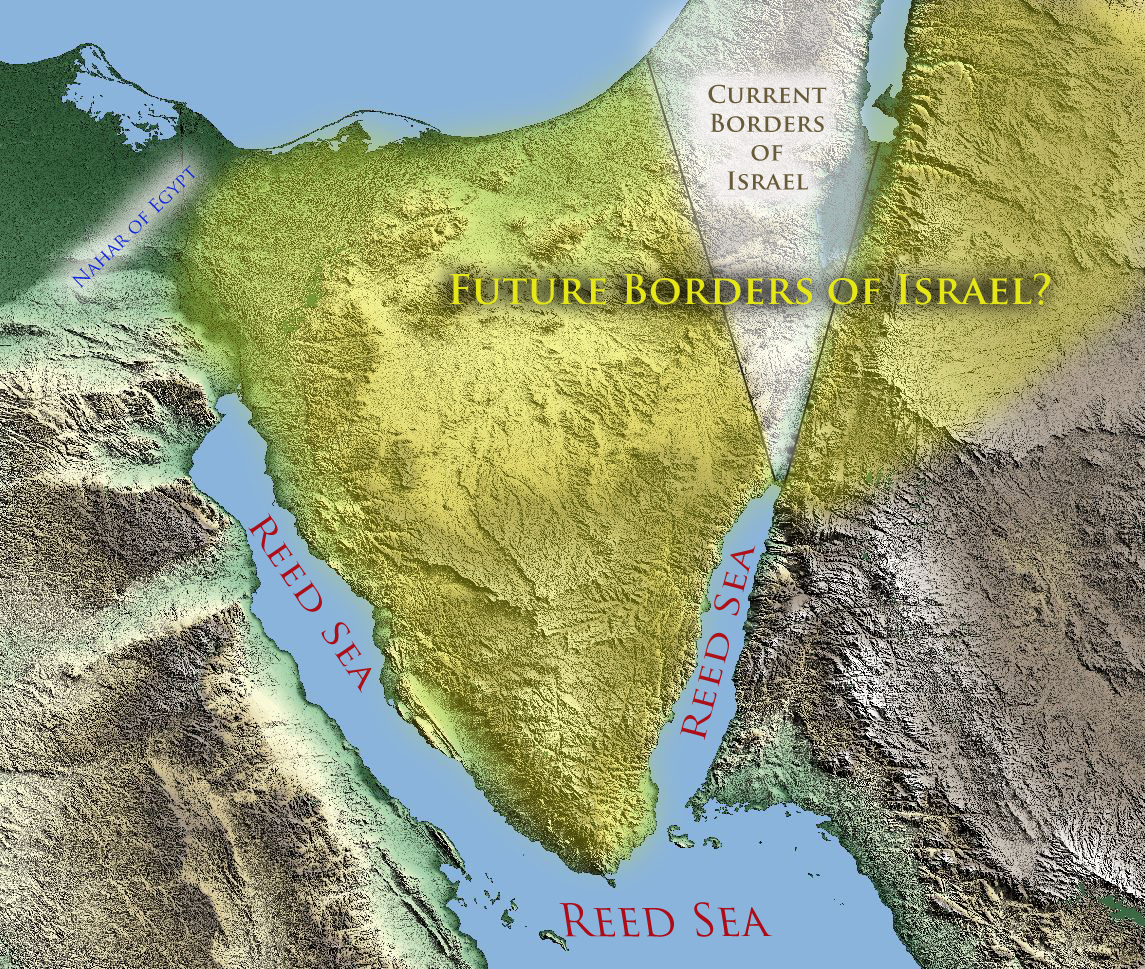
Will Future Israel Include Mount Sinai
This brings me to a final point, that has nagged me about the discussion of Mount Sinai’s geographical location. As important as Mount Sinai is to the history of Israel and the Biblical narrative, why would it not someday be included within the future borders of Israel?
Based upon the above Biblical geographical descriptions, it appears to me that the only place where Mount Sinai would not be included in the future borders of Israel is if it was located in present day Saudi Arabia.
Please I encourage you to do your Berean duty and see if these things be so.
Maranatha.
Part I – Is Mount Sinai in Saudi Arabia
Part II – The Reed Sea Crossing: Which Gulf of the Red Sea?
Part III – Israel’s Crossing of the Reed Sea: The Geographical & Chronological Context
Part IV – Israel’s Crossing of the Reed Sea: Applying the Golden Rule of Bible Interpretation
Part V – The Exodus & Reed Sea Crossing: Symbols of the Bible’s redemptive Message
The location where archeologists found hundreds of ancient dead Egyptian soldiers buried in the mud 1.5 km off shore from the town of Ras Gharib in the Gulf of Suez, along with their horses, chariots, and weapons, with no sign of a boat anywhere, might offer a clue as to where the crossing took place.
I always do find your articles incredibly interesting. Thanks for sharing them with us!
Regarding the “river of Egypt,” scholars have noted that the King of Assyria mentions it in his march on Egypt to conquer it. He stated that his forces came to a “nahal mat Musri,” and that IT HAD NO WATER IN IT. This seems to apply to the dry wadi el Arish, identified with the Bible’s Nahal MIZRAIM, identified with Israel’s southern border, by some scholars. I have noted that Wadi el Arish’s headwaters begin in the vicinity of a Jebel Mushri, perhaps the river took its name from its headwaters area? Near Jebel Mushri were excavated Israelite fortresses. As regards Struse’s observation that the Gulf of Aqaba appears to be too deep for a wind to blow away, he is correct. Wind-set-down works ONLY on large shallow bodies of water, like lakes, bays and estuaries. Yam Suph is the Hebrew for English Red Sea. Yam can refer to a (1) sea, (2) lake, (3) river. Struse noted that Hebrew nachal can refer to a wadi, and thus wadi el Arish is a possible contender for Israel’s southern Border. In fact the Bible describes in great detail Judah’s southern border beginning at the Dead Sea and ending at the Mediterranean Sea. A number of forts are enumerated, the last being Azmon, the Jewish Targum’s Kesam, often identified with today’s Arabic site of Ain el Qusaima, near the headwaters of Wadi el Arish. A Jewish fort near Qusaima has been excavated it lies just north of ain el Qusaima on a high ridge overlooking the drainage basin below. In other words, it is improbable that Israel’s border was to the Nile, it was Wadi el Arish.
As regards Struse’s comments about Mount Sinai (Mount Horeb), the Bible tells us it is an 11 days journey from Mount Sinai to Kadesh Barnea. Today most scholars identify Kadesh with either ain el Qadeis, or a nearby ain el Qudeirat, near the headwaters of the Wadi el Arish. Allowing 20 miles a day for a man to walk, Mt. Sinai would be about 220 miles south of the Israelite Border and Ain el Qadeish/Qudeirat. Excavations at today’s Jebel Musa, also called Ras Safsafa, or Gebel Katherinia, have turned up no trace of an Israelite encampment, despite their being there for almost one year. The only ancient ruins were on the plain of er-Raha, below Gebel Musa, of a Stone Age Village with the remains of crude stone huts and sheep/goat pens, dated by the pottery found there. A Christian Monastery exists nearby built by the Byzantine Emperor Justinian in the 600s AD. In the 400s AD a Christian pilgrimess visited St. Catherine’s monastery and described her journey from Egypt to the Holy Mountain. Her Christian guides pointed out to her stone circles in the valley approaching the sacred mountain, claiming these were pens built by Moses’ Israelites to contain their animals in. Modern archaeology has examined these stone circles and from the pottery associated with these sites, determined they were constructed in Stone Age times, not the days of Moses (circa 1446 BC or 1260 BC, common dates for the Exodus for some scholars). Israeli archaeologists investigated the Sinai after the 6 days war in the 1970s looking for traces of Israelite encampments (looking for pottery debris of circa 1260 BC) and could find none at any well or water source in the Sinai. The only site that had pottery debris of either 1446 BC or 1260 BC was at Jebel Serabit el Khadim, where an Egyptian shrine had been erected to honor the Egyptian goddess of miners, called Hat-Hor (Hat= “House” of Hor=Greek Horus, the Hawk-headed god of the sky). She was worshiped in the form of a cow-goddess and was the sky itself, she bore the Egyptian epiteth NUBT meaning “the golden one.” She appears as cow, and as a human woman with cow ears and horns, she suckles Pharaoh as a calf in some art forms. Various Pharaohs left their names (in the form of Royal Cartouches) at the Shrine, which they repaired and maintained for hundreds of years, and thus we know it was occupied in times associated with the Exodus, circa 1446 BC/1260 BC. Two scholars have proposed that Mount Sinai is Jebel Serabit el Khadim, one was a Jewish scholar in the 1970s from Tel Aviv and the other was a Linda Eckenstein of circa 1920’s. Most scholars deny this association.